METAR & TAF KGLY
Current METAR
Observed 18:55Z
KGLY 271855Z AUTO 19011KT 9SM CLR 36/23 A2983 RMK AO2
- Wind
- 190° @ 11 kt
- Visibility
- 9 SM
- Temp / Dew
- 36°C / 23°C
- Altimeter
- 29.83 inHg
- Clouds
- CLR
- Density alt
- 3,652 ft
- Ceiling
- Unlimited
- Rules
- VFR
Airport info & contacts
Manager on record, flight service, ARTCC, attendance schedule and pattern altitude — published by the FAA and refreshed every 28 days.
Location
- From city
- 4 NM E
- VFR sectional
- KANSAS CITY
- ARTCC
- ZKC · KANSAS CITY
- NOTAM facility
- GLY (NOTAM-D)
Airport manager
- Name
- CLINTON AIRPORT ASSOCIATION, INC.
- Phone
- (660) 885-8889
- Address
- 20 SE AIRPORT ROAD, CLINTON MO 64735
Flight service · Hours
- FSS COU
- COLUMBIA1-800-WX-BRIEF
- Attendance
- MON-FRI · 0800-1700
Frequencies
Tap any row to copy the frequency to your clipboard.
Runways & pattern
Full pagePattern entry · RWY 18
LEFT TRAFFIC| Runway | Heading (°M) | Length | Surface | Traffic |
|---|---|---|---|---|
| 18/36Favored | 181° / 1° | 5,000 ft | CONC | Standard L |
| 04/22 | 44° / 224° | 4,001 ft | ASPH | Standard L |
Runway end performance
| End | TORA | TODA | ASDA | LDA | VGSI | Approach lights | Obstruction |
|---|---|---|---|---|---|---|---|
| 18 | — | — | — | — | PAPI 4-box left(3°) | — | — |
| 36 | — | — | — | — | PAPI 4-box left(3°) | — | — |
| 04 | — | — | — | — | PAPI 4-box left(3.5°) | — | 67', trees, 1298' from thr, 350' R of cntrln, slope 16 |
| 22 | — | — | — | — | PAPI 4-box left(3.5°) | — | — |
Declared distances in feet. TORA = takeoff run available, TODA = takeoff distance, ASDA = accelerate-stop, LDA = landing distance.
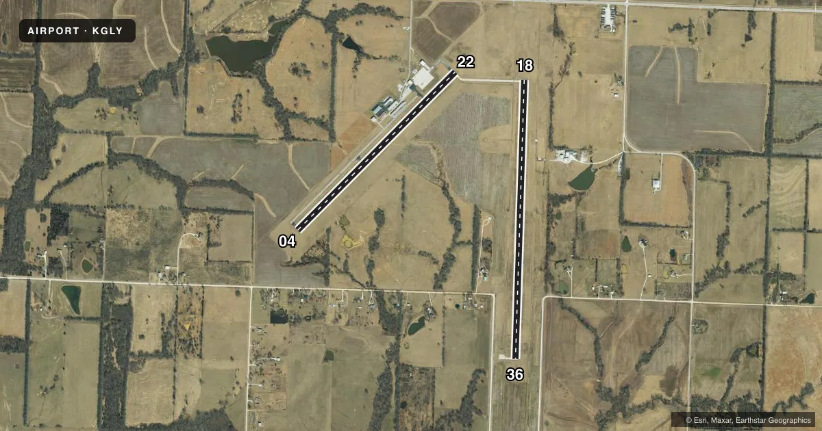
Airport sketch
Runways drawn to scale from FAA survey coordinates, rendered over satellite imagery. Not for navigation.
Approaches & charts
Services on the field
Fuel grades, oxygen, maintenance, ramp storage and lighting — as declared to the FAA by the airport operator.
Fuel & services
- Fuel
- 100LLA+
- Oxygen (bulk)
- Not available
- Airframe repair
- Major
- Power plant repair
- Major
- Other services
- INSTR,RNTL
Ramp & ground
- Transient storage
- Tie-down
- Hangar
- Landing fee
- No fee published
- Customs
- Not available
- Lighting schedule
- SEE RMK
- Beacon schedule
- SS-SR
- Beacon
- White / Green (civil land)(WG)
- Wind indicator
- Lighted
- Segmented circle
- Yes
Fuel & FBOs
Cheapest 100LL and Jet A on the field and nearby. Always confirm with the FBO before taxi.
Airport notes
Surface conditions, obstructions, local procedures, lighting outages and other notes published with each FAA cycle.
General notes
- FOR CD IF UNA TO CTC ON FSS FREQ, CTC WHITEMAN APCH AT 660-687-3132. WHEN WHITEMAN APCH IS CLSD, CTC KANSAS CITY ARTCC AT 913-254-8508.
Lighting notes
- MIRL RWY 04/22 AND RWY 18/36 ACTVT MIRL RWY 04/22 AND RWY 18/36 - CTAF. ACTVT REIL RWYS 04, 18, 22 & 36; PAPI RWYS 04, 18, 22 & 36 - CTAF.
Fuel notes
- 100LLFUEL AVBL 24 HRS. SINGLE POINT JET A AVBL. AFTER HRS CALL ARPT MANAGER, 660-885-8889
Other notes
- CHECK AVAILABILITY, CALL AMGR 660-885-8889
VFR map & nearby airports
VFR sectional. Tap any ICAO chip to open that airport.
Key facts · KGLY
Answer card- ICAO
- KGLY
- Name
- CLINTON RGNL
- Location
- CLINTON, MISSOURI
- Elevation
- 822.5 ft MSL
- Traffic pattern altitude
- 1,822.5 ft MSL (1,000 AGL)
- Control tower
- Non-towered (use CTAF)
- Total runways
- 2
- Longest runway
- 18/36 · 5,000 ft
- Published ILS approaches
- 0
- Published frequencies
- 4
- Magnetic variation
- 1°
- Current flight rules
- VFR
- Current wind
- 190° at 11 kt
- Favored runway now
- RWY 18
Clinton Rgnl sits in Clinton, Missouri. Field elevation is 822.5 ft MSL. The airport has two runways. The longest is runway 18/36 at 5,000 ft. Runway 04/22 is 4,001 ft. There is no control tower. Pattern altitude is not published, so use the standard 1,000 ft AGL for light piston traffic unless the current FAA Chart Supplement says otherwise.
No ILS approaches are published here. The field uses CTAF 122.8. UNICOM is also 122.8. Runway lights on 04/22 and 18/36 are activated by CTAF. REILs and PAPI are also CTAF-activated on both runways. That helps for night arrivals. Brief the lighting setup before you come in.
Clinton Regional Airport is the on-field FBO. It carries 100LL and Jet A. Fuel is listed as available 24 hours. After hours, call the airport manager at the number on file. If you need clearance delivery help and cannot reach flight service, the published remarks direct you to Whiteman Approach first. If that is closed, call Kansas City Center. For a first-time arrival, the main things are the non-towered pattern, the CTAF lighting activation and the fact that there is no published ILS. Check the current FAA Chart Supplement for any updates before departure.