METAR & TAF 0R2
0R2 does not publish a METAR.
Showing the nearest reporting station: KRAW (WARSAW MUNI) · 3.3 NM away. Conditions at 0R2 may differ.
METAR · KRAW
Observed 15:15Z
KRAW 271515Z AUTO 21010G15KT 10SM CLR 32/21 A2991 RMK AO2 T03150211
- Wind
- 210° @ 10G15 kt
- Visibility
- 10 SM
- Temp / Dew
- 32°C / 21°C
- Altimeter
- 29.91 inHg
- Clouds
- CLR
- Density alt
- 3,218 ft
- Ceiling
- Unlimited
- Rules
- VFR
Airport info & contacts
Manager on record, flight service, ARTCC, attendance schedule and pattern altitude — published by the FAA and refreshed every 28 days.
Location
- From city
- 0 NM N
- VFR sectional
- KANSAS CITY
- ARTCC
- ZKC · KANSAS CITY
- NOTAM facility
- COU (NOTAM-D)
Airport manager
- Name
- JIM BENTCH
- Phone
- 660-723-3970
- Address
- PO BOX 17, 122 EAST MAIN, LINCOLN MO 65338
Flight service · Hours
- FSS COU
- COLUMBIA1-800-WX-BRIEF
- Attendance
- Unattended
Frequencies
Tap any row to copy the frequency to your clipboard.
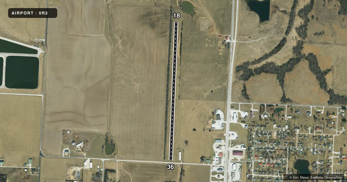
Runways & pattern
Full pagePattern entry · RWY 18
LEFT TRAFFICRunway end performance
| End | TORA | TODA | ASDA | LDA | VGSI | Approach lights | Obstruction |
|---|---|---|---|---|---|---|---|
| 18 | — | — | — | — | — | — | 31', trees, 0' from thr, 118' R of cntrln, slope 1 |
| 36 | — | — | — | — | — | — | 4', fence, 10' from thr, 125' R of cntrln, slope 2 |
Declared distances in feet. TORA = takeoff run available, TODA = takeoff distance, ASDA = accelerate-stop, LDA = landing distance.
Airport sketch
Runways drawn to scale from FAA survey coordinates, rendered over satellite imagery. Not for navigation.
Approaches & charts
Services on the field
Fuel grades, oxygen, maintenance, ramp storage and lighting — as declared to the FAA by the airport operator.
Fuel & services
- Fuel
- Not available
- Oxygen (bottled)
- Not available
- Oxygen (bulk)
- Not available
Ramp & ground
- Transient storage
- Not published
- Landing fee
- No fee published
- Wind indicator
- Yes
- Segmented circle
- No
Fuel & FBOs
Cheapest 100LL and Jet A on the field and nearby. Always confirm with the FBO before taxi.
Airport notes
Surface conditions, obstructions, local procedures, lighting outages and other notes published with each FAA cycle.
General notes
- RWY SOFT AT THLD ENDS AFTER HEAVY RAIN.
- WILDLIFE ON & INVOF ARPT.
- +50 FT TREELINE 125 FT WEST OF RY CENTERLINE FULL LENGTH.
- FOR CD CTC WHITEMAN APCH AT 660-687-3132. WHEN WHITEMAN APCH IS CLSD, CTC KANSAS CITY ARTCC AT 913-254-8508.
Approach & departure obstructions
- 18DSPLCD THLD 7 FT HIGHER THAN RY END ELEVATION; RY 36 DSPLCD THLD 4 FT HIGHER THAN RY END ELEVATION.
- 18RY 18/36 MARKED WITH LARGE YELLOW CONES; RY 18 DSPLCD THLD MARKED WITH 3 LARGE YELLOW CONES ON BOTH SIDES OF RY.
- 18RWY 18 11:1 TO DSPLCD THLD; 1-35 FT TREES 0-585 FT 100 FT R
- 36RWY 36 50:1 TO DSPLCD THLD.
Other notes
- MANAGERWORK PHONE 660-547-3613.
VFR map & nearby airports
VFR sectional. Tap any ICAO chip to open that airport.
Key facts · 0R2
Answer card- ICAO
- 0R2
- Name
- LINCOLN MUNI
- Location
- LINCOLN, MISSOURI
- Elevation
- 940 ft MSL
- Traffic pattern altitude
- 1,940 ft MSL (1,000 AGL)
- Control tower
- Non-towered (use CTAF)
- Total runways
- 1
- Longest runway
- 18/36 · 2,940 ft
- Published ILS approaches
- 0
- Published frequencies
- 1
- Magnetic variation
- 4°
- Current flight rules
- VFR
- Current wind
- 210° at 10 kt
- Favored runway now
- RWY 18
Lincoln Muni sits in Lincoln, Missouri. The field elevation is 940 ft MSL. It has one runway. Runway 18/36 is 2,940 ft of turf, so plan for grass-field performance and soft spots after heavy rain. There is no control tower. CTAF is 122.9. No ILS approaches are published here.
Pattern altitude is not published. Use the standard 1,000 ft AGL pattern unless local traffic or current guidance says otherwise. That puts the light-piston pattern at 1,940 ft MSL based on the field elevation. Runway 18 and 36 are marked with large yellow cones. The remarks also call out wildlife on and near the airport. A treeline sits about 125 feet west of the runway centerline for the full length. Runway 18 has displaced-threshold markings and trees off the departure end area. Runway 36 also has a published obstacle clearance slope to the displaced threshold.
There are no on-field FBOs listed. If you need service, contact the airport operator directly before arrival. For clearance delivery, the published remarks point pilots to Whiteman Approach when it is open. When it is closed, use Kansas City ARTCC. The manager’s work phone is also published in the Chart Supplement.