METAR & TAF K15
K15 does not publish a METAR.
Showing the nearest reporting station: KAIZ (LEE C FINE MEML) · 6.3 NM away. Conditions at K15 may differ.
METAR · KAIZ
Observed 14:56Z
KAIZ 271456Z AUTO 23006KT 10SM CLR 32/23 A2994 RMK AO2 SLP125 T03170228 58003 $
- Wind
- 230° @ 6 kt
- Visibility
- 10 SM
- Temp / Dew
- 32°C / 23°C
- Altimeter
- 29.94 inHg
- Clouds
- CLR
- Density alt
- 3,102 ft
- Ceiling
- Unlimited
- Rules
- VFR
Airport info & contacts
Manager on record, flight service, ARTCC, attendance schedule and pattern altitude — published by the FAA and refreshed every 28 days.
Location
- From city
- 1 NM SW
- VFR sectional
- KANSAS CITY
- ARTCC
- ZKC · KANSAS CITY
- NOTAM facility
- COU (NOTAM-D)
Airport manager
- Name
- TY DINSDALE
- Phone
- 573-348-4469
- Address
- 1000 CITY PARKWAY, OSAGE BEACH MO 65065
Flight service · Hours
- FSS COU
- COLUMBIA1-800-WX-BRIEF
- Attendance
- APR-SEP · SAT-THU · 0800-1800
- APR-SEP · FRI · 0800-1800
- OCT-MAR · 0800-1800
Frequencies
Tap any row to copy the frequency to your clipboard.
Runways & pattern
Full pagePattern entry · RWY 14
LEFT TRAFFICRunway end performance
| End | TORA | TODA | ASDA | LDA | VGSI | Approach lights | Obstruction |
|---|---|---|---|---|---|---|---|
| 14 | — | — | — | — | — | — | 20', pline, 447' from thr, 290' R of cntrln, slope 12 |
| 32 | — | — | — | — | PAPI 4-box left(3.5°) | — | 34', trees, 330' from thr, 250' R of cntrln, slope 3 |
Declared distances in feet. TORA = takeoff run available, TODA = takeoff distance, ASDA = accelerate-stop, LDA = landing distance.
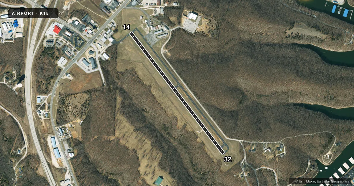
Airport sketch
Runways drawn to scale from FAA survey coordinates, rendered over satellite imagery. Not for navigation.
Approaches & charts
Services on the field
Fuel grades, oxygen, maintenance, ramp storage and lighting — as declared to the FAA by the airport operator.
Fuel & services
- Fuel
- 100LLA
- Oxygen (bottled)
- Not available
- Oxygen (bulk)
- Not available
Ramp & ground
- Transient storage
- Tie-down
- Hangar
- Landing fee
- No fee published
- Customs
- Not available
- Lighting schedule
- SEE RMK
- Beacon schedule
- SS-SR
- Beacon
- White / Green (civil land)(WG)
- Wind indicator
- Lighted
- Segmented circle
- No
Fuel & FBOs
Cheapest 100LL and Jet A on the field and nearby. Always confirm with the FBO before taxi.
Airport notes
Surface conditions, obstructions, local procedures, lighting outages and other notes published with each FAA cycle.
General notes
- DEER ON AND INVOF RY & TWYS DUSK AND AFT DARK.
- FOR CD CTC MIZZOU APCH AT 417-868-5620/5619.
Lighting notes
- ACTVT PAPI RWY 32; MIRL RWY 14/32 - CTAF.
Runway surface & condition
- 14/32RESTRICTED TO ACFT 12,500 LBS MAX GWT OR LESS; PPR FOR ACFT EXCEEDING 12,500 LBS CALL AMGR ON 573-302-2003.
VFR map & nearby airports
VFR sectional. Tap any ICAO chip to open that airport.
Key facts · K15
Answer card- ICAO
- K15
- Name
- GRAND GLAIZE-OSAGE BEACH
- Location
- OSAGE BEACH, MISSOURI
- Elevation
- 876.3 ft MSL
- Traffic pattern altitude
- 1,876.3 ft MSL (1,000 AGL)
- Control tower
- Non-towered (use CTAF)
- Total runways
- 1
- Longest runway
- 14/32 · 3,205 ft
- Published ILS approaches
- 0
- Published frequencies
- 4
- Magnetic variation
- 2°
- Current flight rules
- VFR
- Current wind
- 230° at 6 kt
- Favored runway now
- RWY 14
Grand Glaize-Osage Beach Airport (K15) sits in Osage Beach, Missouri. Field elevation is 876.3 ft MSL. The airport has one runway. Runway 14/32 is 3,205 ft long with an asphalt surface. There is no control tower. Pattern altitude is not published, so use 1,000 ft AGL for light piston traffic unless the current Chart Supplement says otherwise. No ILS approaches are published here.
Osage Beach Airport is the on-field FBO. It carries 100LL and Jet A. CTAF and UNICOM are both 122.8. Mizzou Approach is listed on 124.1 and 353.925. Published remarks say the runway 32 PAPI is activated. Medium intensity runway lights are available for both runway ends and controlled by CTAF. Deer are reported on and near the runways and taxiways at dusk and after dark. That is a real factor for arrival and departure planning.
This field is limited to aircraft at or below 12,500 lb maximum gross weight. Heavier aircraft need prior permission from the airport manager before operating here. If you need clearance delivery, contact Mizzou Approach at the published phone numbers before departure. For a first visit, plan for an uncontrolled airport environment. Watch the wildlife. Verify the current Chart Supplement for any changes before you go.