METAR & TAF KVER
Current METAR
Observed 13:35Z
KVER 271335Z AUTO 20005KT 10SM CLR 28/25 A2989 RMK AO2 T02800245
- Wind
- 200° @ 5 kt
- Visibility
- 10 SM
- Temp / Dew
- 28°C / 25°C
- Altimeter
- 29.89 inHg
- Clouds
- CLR
- Density alt
- 2,484 ft
- Ceiling
- Unlimited
- Rules
- VFR
Airport info & contacts
Manager on record, flight service, ARTCC, attendance schedule and pattern altitude — published by the FAA and refreshed every 28 days.
Location
- From city
- 3 NM SE
- VFR sectional
- KANSAS CITY
- Pattern altitude
- 785 ft AGL · 1,500 ft MSL
- ARTCC
- ZKC · KANSAS CITY
- NOTAM facility
- COU (NOTAM-D)
Airport manager
- Name
- JOHN TAYLOR
- Phone
- 660-882-3364
- Address
- 20044 PEARRE RD, BOONVILLE MO 65233
Flight service · Hours
- FSS COU
- COLUMBIA1-800-WX-BRIEF
- Attendance
- 0800-2000
Frequencies
Tap any row to copy the frequency to your clipboard.
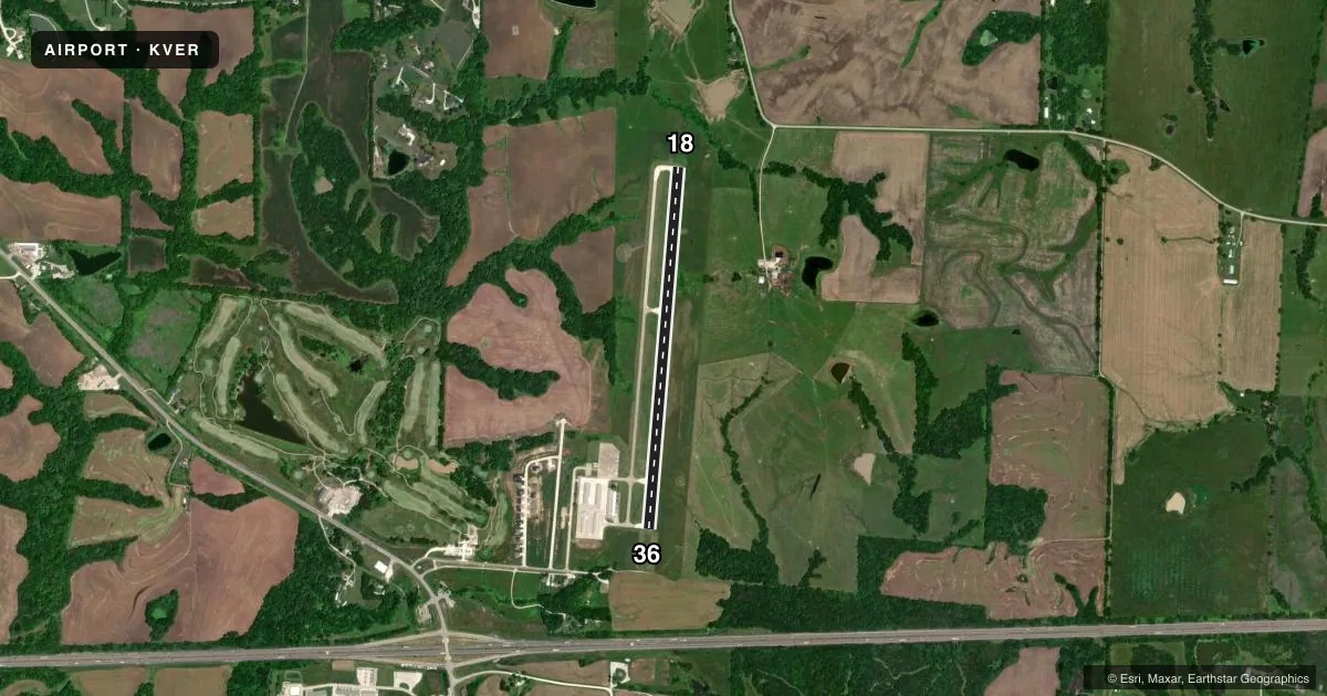
Runways & pattern
Full pagePattern entry · RWY 18
LEFT TRAFFICRunway end performance
| End | TORA | TODA | ASDA | LDA | VGSI | Approach lights | Obstruction |
|---|---|---|---|---|---|---|---|
| 18 | — | — | — | — | PAPI 4-box left(3°) | — | — |
| 36 | — | — | — | — | PAPI 4-box left(3°) | — | 57', tree, 1700' from thr, 140' R of cntrln, slope 26 |
Declared distances in feet. TORA = takeoff run available, TODA = takeoff distance, ASDA = accelerate-stop, LDA = landing distance.
Airport sketch
Runways drawn to scale from FAA survey coordinates, rendered over satellite imagery. Not for navigation.
Approaches & charts
Services on the field
Fuel grades, oxygen, maintenance, ramp storage and lighting — as declared to the FAA by the airport operator.
Fuel & services
- Fuel
- 100LLA
- Oxygen (bottled)
- Not available
- Oxygen (bulk)
- Not available
- Airframe repair
- Major
- Power plant repair
- Major
- Other services
- AGRI,INSTR,RNTL
Ramp & ground
- Transient storage
- Tie-down
- Landing fee
- No fee published
- Customs
- Not available
- Lighting schedule
- SEE RMK
- Beacon schedule
- SS-SR
- Beacon
- White / Green (civil land)(WG)
- Wind indicator
- Lighted
- Segmented circle
- Yes
Fuel & FBOs
Cheapest 100LL and Jet A on the field and nearby. Always confirm with the FBO before taxi.
Airport notes
Surface conditions, obstructions, local procedures, lighting outages and other notes published with each FAA cycle.
General notes
- EXTSV STUDENT PILOT TRNG INVOF ARPT.
- NOISE ABATEMENT, FOR RY 36 FLY RY CNTRLN TO 1,500 FT BEFORE TURNING ON CRS.
- RY 18 CALM WIND RY.
- INTENSIVE AERIAL CROP-DUSTING ACTIVITY APRIL-OCTOBER
- FOR CD CTC MIZZOU APCH AT 417-868-5620/5619.
Lighting notes
- ACTVT MIRL RY 18/36; PAPI RYS 18 & 36; REIL RYS 18 & 36 - CTAF.
Fuel notes
- 100LLSELF-SVC FUEL AVBL 24 HRS.
Other notes
- THIS AIRPORT HAS BEEN SURVEYED BY THE NATIONAL GEODETIC SURVEY.
- PROVIDED AIRCRAFT IN THE TIE-DOWN AREA ARE PARKED WITH THE TAILS TOWARD THE WEST TO AVOID PENETRATION OF THE TRANSITIONAL SURFACE.
VFR map & nearby airports
VFR sectional. Tap any ICAO chip to open that airport.
Key facts · KVER
Answer card- ICAO
- KVER
- Name
- JESSE VIERTEL MEML
- Location
- BOONVILLE, MISSOURI
- Elevation
- 715 ft MSL
- Traffic pattern altitude
- 1,500 ft MSL (785 AGL)
- Control tower
- Non-towered (use CTAF)
- Total runways
- 1
- Longest runway
- 18/36 · 4,000 ft
- Published ILS approaches
- 0
- Published frequencies
- 3
- Magnetic variation
- 2°
- Current flight rules
- VFR
- Current wind
- 200° at 5 kt
- Favored runway now
- RWY 18
Jesse Viertel Meml (KVER) sits in Boonville, Missouri. Field elevation is 715 ft MSL. The airport has one runway. Runway 18/36 is 4,000 ft long with a concrete surface. There is no control tower. Pattern altitude is 785 ft AGL, which is 1,500 ft MSL.
No ILS approaches are published here. The field uses CTAF 122.7 and UNICOM 122.7. Mizzou Approach is listed on 124.375. For clearance delivery, the published remarks direct pilots to contact Mizzou Approach by phone. Tig-Air Aviation is on the field. It carries 100LL and Jet A. Self-serve 100LL is available 24 hours.
There are a few operational items worth planning for. Runway 18 is the calm wind runway. For noise abatement on runway 36, stay on the runway centerline to 1,500 feet before turning on course. Intensive crop-dusting activity is published from April through October. Student training is also active in the area. Medium intensity runway lights are installed on 18/36. PAPI and REIL are installed on both runway ends. If you are new to KVER, expect a busy local training environment and keep your scan tight in the pattern.