METAR & TAF KOZS
Current METAR
Observed 17:15Z
KOZS 271715Z AUTO 25010G14KT 10SM CLR 35/18 A2992 RMK AO2
- Wind
- 250° @ 10G14 kt
- Visibility
- 10 SM
- Temp / Dew
- 35°C / 18°C
- Altimeter
- 29.92 inHg
- Clouds
- CLR
- Density alt
- 3,717 ft
- Ceiling
- Unlimited
- Rules
- VFR
Airport info & contacts
Manager on record, flight service, ARTCC, attendance schedule and pattern altitude — published by the FAA and refreshed every 28 days.
Location
- From city
- 3 NM SE
- VFR sectional
- KANSAS CITY
- ARTCC
- ZKC · KANSAS CITY
- NOTAM facility
- OZS (NOTAM-D)
Airport manager
- Name
- DESTINY CAMPBELL
- Phone
- 573-346-0300
- Address
- 20 AIRPORT DRIVE, CAMDENTON MO 65020
Flight service · Hours
- FSS COU
- COLUMBIA1-800-WX-BRIEF
- Attendance
- OCT-APR · 0800-1800
- MAY-SEP · 0800-2000
Frequencies
Tap any row to copy the frequency to your clipboard.
Runways & pattern
Full pagePattern entry · RWY 33
LEFT TRAFFICRunway end performance
| End | TORA | TODA | ASDA | LDA | VGSI | Approach lights | Obstruction |
|---|---|---|---|---|---|---|---|
| 15 | — | — | — | — | PAPI 4-box left(3°) | — | — |
| 33 | — | — | — | — | PAPI 4-box left(3°) | — | — |
Declared distances in feet. TORA = takeoff run available, TODA = takeoff distance, ASDA = accelerate-stop, LDA = landing distance.
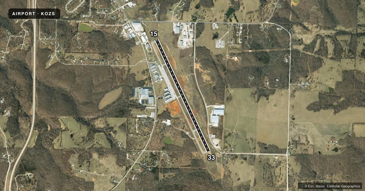
Airport sketch
Runways drawn to scale from FAA survey coordinates, rendered over satellite imagery. Not for navigation.
Approaches & charts
Services on the field
Fuel grades, oxygen, maintenance, ramp storage and lighting — as declared to the FAA by the airport operator.
Fuel & services
- Fuel
- 100LLA+
- Oxygen (bottled)
- Low pressure
- Oxygen (bulk)
- Not available
- Airframe repair
- Major
- Power plant repair
- Major
- Other services
- INSTR
Ramp & ground
- Transient storage
- Tie-down
- Hangar
- Landing fee
- No fee published
- Customs
- Not available
- Lighting schedule
- SEE RMK
- Beacon schedule
- SS-SR
- Beacon
- White / Green (civil land)(WG)
- Wind indicator
- Lighted
- Segmented circle
- Yes
Fuel & FBOs
Cheapest 100LL and Jet A on the field and nearby. Always confirm with the FBO before taxi.
Airport notes
Surface conditions, obstructions, local procedures, lighting outages and other notes published with each FAA cycle.
General notes
- WILDLIFE ON & INVOF ARPT.
- FOR CD CTC MIZZOU APCH AT 417-868-5620/5619.
Lighting notes
- ACTVT REIL RWYS 15 & 33; PAPI RWYS 15 & 33' AND MIRL RWY 15/33 - CTAF.
Other notes
- PROVIDED APCH TO EACH RWY IS MAINTAINED FOR A MIN 20:1 GLIDE SLOPE & TRANSITIONAL SURFACE MAINTAINED FOR A 7:1 SLOPE.
VFR map & nearby airports
VFR sectional. Tap any ICAO chip to open that airport.
Key facts · KOZS
Answer card- ICAO
- KOZS
- Name
- CAMDENTON MEML-LAKE RGNL
- Location
- CAMDENTON, MISSOURI
- Elevation
- 1,061.7 ft MSL
- Traffic pattern altitude
- 2,061.7 ft MSL (1,000 AGL)
- Control tower
- Non-towered (use CTAF)
- Total runways
- 1
- Longest runway
- 15/33 · 5,002 ft
- Published ILS approaches
- 0
- Published frequencies
- 4
- Magnetic variation
- 0°
- Current flight rules
- VFR
- Current wind
- 250° at 10 kt
- Favored runway now
- RWY 33
Camdenton Memorial-Lake Regional Airport sits in Camdenton, Missouri. Field elevation is 1,061.7 ft MSL. The airport has one runway, 15/33, which is 5,002 ft long. There is no control tower. CTAF and UNICOM are both 122.8. Mizzou Approach uses 124.1 and 353.925 for approach and departure services.
No ILS approaches are published here. Pattern altitude is not published, so use standard traffic pattern planning unless the current Chart Supplement says otherwise. Lake Aviation Center is on the field. It carries 100LL and Jet A. Call them at (573) 346-0300 for current services.
A few published remarks matter for planning. Runway end identifier lights, PAPI and medium intensity runway lights are activated on runway 15/33. Wildlife is reported on and near the airport. Keep a sharp scan on taxi, takeoff and landing. The airport also notes approach surfaces are maintained to published slope standards. For clearance delivery, contact Mizzou Approach by phone before departure if you need that service. This is a field where a first-time pilot should brief the lighting, watch for wildlife and confirm current pattern and approach details in the current FAA Chart Supplement before flying in.