METAR & TAF KMYJ
Current METAR
Observed 05:35Z
KMYJ 270535Z AUTO 21006KT 10SM CLR 25/25 A2990 RMK AO2
- Wind
- 210° @ 6 kt
- Visibility
- 10 SM
- Temp / Dew
- 25°C / 25°C
- Altimeter
- 29.90 inHg
- Clouds
- CLR
- Density alt
- 2,245 ft
- Ceiling
- Unlimited
- Rules
- VFR
Airport info & contacts
Manager on record, flight service, ARTCC, attendance schedule and pattern altitude — published by the FAA and refreshed every 28 days.
Location
- From city
- 3 NM E
- VFR sectional
- KANSAS CITY
- ARTCC
- ZKC · KANSAS CITY
- NOTAM facility
- STL (NOTAM-D)
Airport manager
- Name
- JAY JACOBI
- Phone
- 573-581-0162
- Address
- 5720 HWY 54 EAST, MEXICO MO 65265
Flight service · Hours
- FSS STL
- SAINT LOUIS1-800-WX-BRIEF
- Attendance
- MON-FRI · 0800-1700
- SAT · 0800-1500
- SUN · 1000-1400
Frequencies
Tap any row to copy the frequency to your clipboard.
Runways & pattern
Full pagePattern entry · RWY 18
LEFT TRAFFIC| Runway | Heading (°M) | Length | Surface | Traffic |
|---|---|---|---|---|
| 06/24 | 64° / 244° | 5,501 ft | CONC | Standard L |
| 18/36Favored | 180° / 0° | 3,200 ft | ASPH-CONC | Standard L |
Runway end performance
| End | TORA | TODA | ASDA | LDA | VGSI | Approach lights | Obstruction |
|---|---|---|---|---|---|---|---|
| 24 | — | — | — | — | PAPI 4-box left(3°) | MALS | 59', trees, 1770' from thr, 278' R of cntrln, slope 26 |
Declared distances in feet. TORA = takeoff run available, TODA = takeoff distance, ASDA = accelerate-stop, LDA = landing distance.
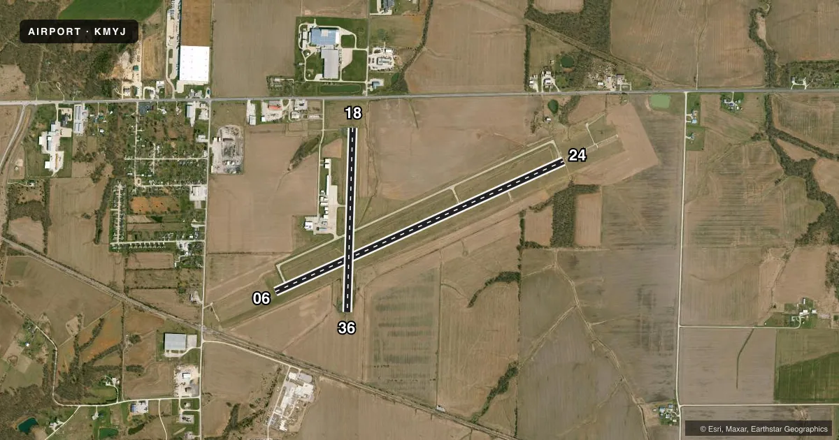
Airport sketch
Runways drawn to scale from FAA survey coordinates, rendered over satellite imagery. Not for navigation.
Approaches & charts
ILS · 1
Services on the field
Fuel grades, oxygen, maintenance, ramp storage and lighting — as declared to the FAA by the airport operator.
Fuel & services
- Fuel
- 100LLAMOGAS
- Oxygen (bottled)
- Not available
- Oxygen (bulk)
- Not available
- Airframe repair
- Major
- Power plant repair
- Major
- Other services
- AGRI,INSTR,RNTL
Ramp & ground
- Transient storage
- Tie-down
- Landing fee
- No fee published
- Customs
- Not available
- Lighting schedule
- SEE RMK
- Beacon schedule
- SS-SR
- Beacon
- White / Green (civil land)(WG)
- Wind indicator
- Lighted
- Segmented circle
- Yes
Fuel & FBOs
Cheapest 100LL and Jet A on the field and nearby. Always confirm with the FBO before taxi.
Airport notes
Surface conditions, obstructions, local procedures, lighting outages and other notes published with each FAA cycle.
General notes
- CROP DUSTING ACFT ON & INVOF ARPT.
- FOR CD CTC MIZZOU APCH AT 417-868-5620/5619.
Lighting notes
- ACTVT MALS RWY 24; REIL RWY 18; PAPI RWY 24 - CTAF. MIRL RWY 06/24 & 18/36 SS-SR LOW INTST; INCR INTST - CTAF.
Fuel notes
- 100LL100LL 24 HR CREDIT CARD FUEL SYSTEM. FOR JET A FUEL AFTER HRS CALL AIRPORT MGR 573-473-7758.
Approach & departure obstructions
- 24RWY 24 36:1 BASED ON DSPLCD THR.
VFR map & nearby airports
VFR sectional. Tap any ICAO chip to open that airport.
Key facts · KMYJ
Answer card- ICAO
- KMYJ
- Name
- MEXICO MEML
- Location
- MEXICO, MISSOURI
- Elevation
- 822.6 ft MSL
- Traffic pattern altitude
- 1,822.6 ft MSL (1,000 AGL)
- Control tower
- Non-towered (use CTAF)
- Total runways
- 2
- Longest runway
- 06/24 · 5,501 ft
- Published ILS approaches
- 1
- Published frequencies
- 2
- Magnetic variation
- 2°
- Current flight rules
- VFR
- Current wind
- 210° at 6 kt
- Favored runway now
- RWY 18
Mexico Memorial Airport sits in Mexico, Missouri. The field elevation is 822.6 ft MSL. It has two runways. The longest is runway 06/24 at 5,501 ft. There is no control tower. Pattern altitude is not published, so use 1,000 ft AGL for light piston operations unless the current Chart Supplement says otherwise.
Runway 24 has the ILS approach. That makes it the main precision option here. The airport also has CTAF on 122.9 and Mizzou Approach on 124.375 for approach and departure work. Published remarks note MALS lighting on runway 24. Runway 18 has REIL lighting. Runway 24 also has PAPI that is controlled by CTAF. Runway lights on 06/24 and 18/36 are medium intensity from sunset to sunrise at low intensity. Increase the lights with CTAF as needed.
Mexico Memorial Airport has one on-field FBO. Mexico Memorial Airport carries 100LL, Jet A Prist and MOGAS. 100LL is available 24 hours through a credit card fuel system. Crop dusting aircraft operate on and near the airport. Keep your scan sharp in the pattern and on taxi. Runway 24 also has a published obstacle clearance slope based on the displaced threshold. That matters if you are planning a short final or a heavy departure. Check the current Chart Supplement for any updated operational notes before you go.