METAR & TAF H19
H19 does not publish a METAR.
Showing the nearest reporting station: KHAE (HANNIBAL RGNL) · 23.7 NM away. Conditions at H19 may differ.
METAR · KHAE
Observed 03:55Z
KHAE 270355Z AUTO 22004KT 10SM CLR 30/25 A2989 RMK AO2
- Wind
- 220° @ 4 kt
- Visibility
- 10 SM
- Temp / Dew
- 30°C / 25°C
- Altimeter
- 29.89 inHg
- Clouds
- CLR
- Density alt
- 2,943 ft
- Ceiling
- Unlimited
- Rules
- VFR
Airport info & contacts
Manager on record, flight service, ARTCC, attendance schedule and pattern altitude — published by the FAA and refreshed every 28 days.
Location
- From city
- 2 NM NW
- VFR sectional
- KANSAS CITY
- ARTCC
- ZKC · KANSAS CITY
- NOTAM facility
- STL (NOTAM-D)
Airport manager
- Name
- LINDA LUEBRECHT
- Phone
- 573-470-2930
- Address
- 16 W CHURCH ST, BOWLING GREEN MO 63334
Flight service · Hours
- FSS STL
- SAINT LOUIS1-800-WX-BRIEF
- Attendance
- ALL
Frequencies
Tap any row to copy the frequency to your clipboard.
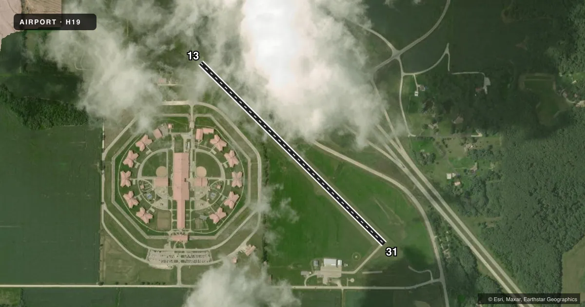
Runways & pattern
Full pagePattern entry · RWY 13
LEFT TRAFFICRunway end performance
| End | TORA | TODA | ASDA | LDA | VGSI | Approach lights | Obstruction |
|---|---|---|---|---|---|---|---|
| 13 | — | — | — | — | PAPI 2-box left(3°) | — | — |
| 31 | — | — | — | — | PAPI 2-box left(3°) | — | 48', tree, 655' from thr, 170' R of cntrln, slope 9 |
Declared distances in feet. TORA = takeoff run available, TODA = takeoff distance, ASDA = accelerate-stop, LDA = landing distance.
Airport sketch
Runways drawn to scale from FAA survey coordinates, rendered over satellite imagery. Not for navigation.
Approaches & charts
Services on the field
Fuel grades, oxygen, maintenance, ramp storage and lighting — as declared to the FAA by the airport operator.
Fuel & services
- Fuel
- 100LL
- Oxygen (bottled)
- Not available
- Oxygen (bulk)
- Not available
- Other services
- AGRI
Ramp & ground
- Transient storage
- Tie-down
- Landing fee
- No fee published
- Customs
- Not available
- Lighting schedule
- SEE RMK
- Beacon schedule
- SS-SR
- Beacon
- White / Green (civil land)(WG)
- Wind indicator
- Lighted
- Segmented circle
- Yes
Fuel & FBOs
Cheapest 100LL and Jet A on the field and nearby. Always confirm with the FBO before taxi.
Airport notes
Surface conditions, obstructions, local procedures, lighting outages and other notes published with each FAA cycle.
General notes
- DO NOT OVERFLY PRISON AREA.
- FOR CD CTC KANSAS CITY ARTCC AT 913-254-8508.
Lighting notes
- ACTVT REIL RWY 13 AND 31; PAPI RWY 13 AND 31; MIRL RWY 13/31 - CTAF.
Approach & departure obstructions
- 1330-50 FT TALL TREES 0-125 FT FROM RWY 13 THRESHOLD 150-250 FT R
Other notes
- UNICOM IREG MNTD.
- MANAGEREMAIL: IAMJAKEMCDONALD@GMAIL.COM.
VFR map & nearby airports
VFR sectional. Tap any ICAO chip to open that airport.
Key facts · H19
Answer card- ICAO
- H19
- Name
- BOWLING GREEN MUNI
- Location
- BOWLING GREEN, MISSOURI
- Elevation
- 891.4 ft MSL
- Traffic pattern altitude
- 1,891.4 ft MSL (1,000 AGL)
- Control tower
- Non-towered (use CTAF)
- Total runways
- 1
- Longest runway
- 13/31 · 3,203 ft
- Published ILS approaches
- 0
- Published frequencies
- 2
- Magnetic variation
- 1°
- Current flight rules
- VFR
- Current wind
- 220° at 4 kt
- Favored runway now
- RWY 13
Bowling Green Muni sits in Bowling Green, Missouri. Field elevation is 891.4 ft MSL. The airport has one runway. Runway 13/31 is 3,203 ft long with a concrete surface. There is no control tower. CTAF and UNICOM are both 122.8. No ILS approaches are published here.
The pattern altitude is not published in the facts, so use the standard 1,000 ft AGL unless the current Chart Supplement says otherwise. For this field that puts the traffic pattern at about 1,891 ft MSL. Runway 13 and runway 31 both have runway end identifier lights. Precision approach path indicators are installed on both ends. Medium intensity runway lights on 13/31 are controlled by CTAF.
There are no on-field FBOs listed in the facts. UNICOM is irregularly monitored, so plan to make your calls early and verify current field status before arrival. The published remarks also say not to overfly the prison area. Runway 13 has trees close to the threshold on the right side, so pay attention on short final and during departure planning. If you need clearance delivery, contact Kansas City ARTCC at 913-254-8508.