METAR & TAF M71
M71 does not publish a METAR.
Showing the nearest reporting station: KFYG (WASHINGTON RGNL) · 18.9 NM away. Conditions at M71 may differ.
METAR · KFYG
Observed 19:35Z
KFYG 261935Z AUTO VRB05KT 9SM CLR 35/28 A2990 RMK AO2
- Wind
- VAR @ 5 kt
- Visibility
- 9 SM
- Temp / Dew
- 35°C / 28°C
- Altimeter
- 29.90 inHg
- Clouds
- CLR
- Density alt
- 3,118 ft
- Ceiling
- Unlimited
- Rules
- VFR
Airport info & contacts
Manager on record, flight service, ARTCC, attendance schedule and pattern altitude — published by the FAA and refreshed every 28 days.
Location
- From city
- 4 NM SW
- VFR sectional
- KANSAS CITY
- ARTCC
- ZKC · KANSAS CITY
- NOTAM facility
- STL (NOTAM-D)
Airport manager
- Name
- RICHARD GREEN
- Phone
- 314-650-5804
- Address
- 2166 MYERS ROAD, TROY MO 63379
Flight service · Hours
- FSS STL
- SAINT LOUIS1-800-WX-BRIEF
- Attendance
- Unattended
Frequencies
Tap any row to copy the frequency to your clipboard.
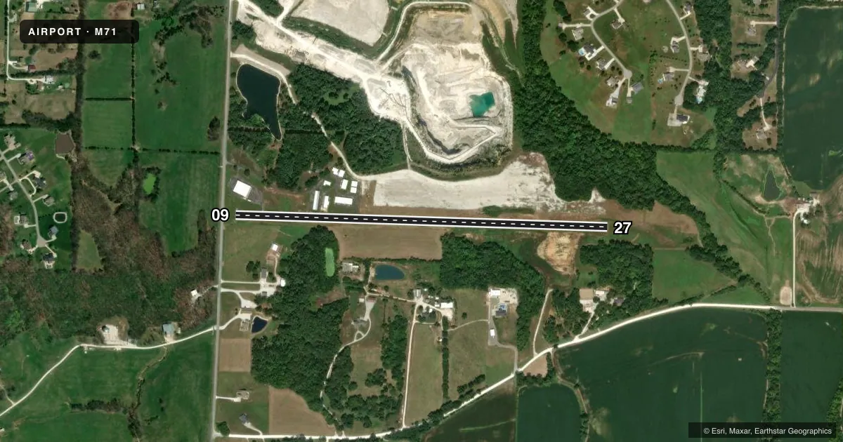
Runways & pattern
Full pagePattern entry · RWY 27
LEFT TRAFFICRunway end performance
| End | TORA | TODA | ASDA | LDA | VGSI | Approach lights | Obstruction |
|---|---|---|---|---|---|---|---|
| 09 | — | — | — | — | — | — | 33', trees, 308' from thr, 120' R of cntrln, slope 3 |
| 27 | — | — | — | — | — | — | 35', trees, 850' from thr, 136' R of cntrln, slope 18 |
Declared distances in feet. TORA = takeoff run available, TODA = takeoff distance, ASDA = accelerate-stop, LDA = landing distance.
Airport sketch
Runways drawn to scale from FAA survey coordinates, rendered over satellite imagery. Not for navigation.
Approaches & charts
Services on the field
Fuel grades, oxygen, maintenance, ramp storage and lighting — as declared to the FAA by the airport operator.
Fuel & services
- Fuel
- Not available
Ramp & ground
- Transient storage
- Hangar
- Wind indicator
- Yes
- Segmented circle
- No
Fuel & FBOs
Cheapest 100LL and Jet A on the field and nearby. Always confirm with the FBO before taxi.
Airport notes
Surface conditions, obstructions, local procedures, lighting outages and other notes published with each FAA cycle.
General notes
- NTSD RY SAFETY AREA BYND EACH RY END & ALONG RY EDGES; RW 09 END HAS LARGE DROP-OFF; RY 27 INCORRECT TERRAIN GRADES WITH BRUSH & TREES; BRUSH, SMALL TREES, EXCESSIVE EDGE DROPS & DITCHES ALONG PVMT EDGES.
- HIGH GND, BRUSH, TREES, AND BLDGS PENETRATE PRIMARY AND TRANSITIONAL SURFACES & CLOSE TO RY EDGES.
- WILDLIFE ON & INVOF ARPT.
- FOR CD CTC ST LOUIS APCH AT 314-890-1017.
Approach & departure obstructions
- 09POWERLINES 125 FT R AND L, 170 FT FM RWY END; +1-35 FT TREES, 118-200 FT FM RWY END, 70-125 FT R.
- 27+1-6 FT GND & BRUSH, 0-200 FT FM RY END, 100-145 FT L.
Other notes
- MAINTAIN CLEAR 20:1 APCH SLOPE; MAINTAIN CLEAR 7:1 TRANSITIONAL SFC SLOPE.
- MANAGERAIRPORT PHYSICAL ADDRESS.
VFR map & nearby airports
VFR sectional. Tap any ICAO chip to open that airport.
Key facts · M71
Answer card- ICAO
- M71
- Name
- GREENSFIELD
- Location
- MOSCOW MILLS, MISSOURI
- Elevation
- 559 ft MSL
- Traffic pattern altitude
- 1,559 ft MSL (1,000 AGL)
- Control tower
- Non-towered (use CTAF)
- Total runways
- 1
- Longest runway
- 09/27 · 3,227 ft
- Published ILS approaches
- 0
- Published frequencies
- 1
- Magnetic variation
- 2°
- Current flight rules
- VFR
- Current wind
- 000° at 5 kt
- Favored runway now
- RWY 27
Greensfield (M71) sits in Moscow Mills, Missouri. Field elevation is 559 ft MSL. The airport has one runway. Runway 09/27 is 3,227 ft long and asphalt. There is no control tower. CTAF is 122.9.
No ILS approaches are published for M71. Pattern altitude is not published, so a light piston pilot should plan on the standard 1,000 ft AGL unless the current Chart Supplement says otherwise. The field is surrounded by terrain and obstacles that matter. Published remarks call out high ground, brush, trees and buildings near the runway edges. Runway safety areas are not standard. Runway 09 has a large drop-off beyond the end. Runway 27 has brush and trees near the end. It also has edge drops and ditches along the pavement.
Wildlife is also present on and near the airport. For clearance delivery, the published note says to contact St Louis Approach at 314-890-1017. No on-field FBOs are listed, so verify services with the airport operator or call the field directly before you go. If you are planning a first visit, treat this as a short-field, obstacle-aware arrival. Keep the published slopes in mind. The remarks ask for a clear 20 to 1 approach slope and a clear 7 to 1 transitional surface slope.