METAR & TAF KSET
Current METAR
Observed 08:54Z
KSET 270854Z AUTO 22004KT 8SM CLR 26/25 A2984 RMK AO2 SLP099 T02610250 55006
- Wind
- 220° @ 4 kt
- Visibility
- 8 SM
- Temp / Dew
- 26°C / 25°C
- Altimeter
- 29.84 inHg
- Clouds
- CLR
- Density alt
- 1,961 ft
- Ceiling
- Unlimited
- Rules
- VFR
Airport info & contacts
Manager on record, flight service, ARTCC, attendance schedule and pattern altitude — published by the FAA and refreshed every 28 days.
Location
- From city
- 9 NM NE
- VFR sectional
- ST LOUIS
- ARTCC
- ZKC · KANSAS CITY
- NOTAM facility
- SET (NOTAM-D)
Airport manager
- Name
- PETER KAMBEITZ
- Phone
- 636-949-1893
- Address
- 6390 GRAFTON FERRY RD, PORTAGE DES SIOUX MO 63373
Flight service · Hours
- FSS STL
- SAINT LOUIS1-800-WX-BRIEF
- Attendance
- NOV-MAR · 0730-1630
- APR-OCT · 0730-1630 DUSK
Frequencies
Tap any row to copy the frequency to your clipboard.
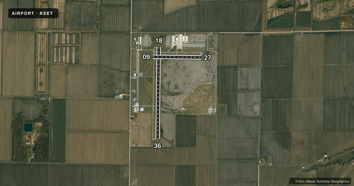
Runways & pattern
Full pagePattern entry · RWY 18
LEFT TRAFFIC| Runway | Heading (°M) | Length | Surface | Traffic |
|---|---|---|---|---|
| 18/36Favored | 180° / 0° | 3,800 ft | ASPH | Standard L |
| 09/27 | 90° / 270° | 2,000 ft | ASPH | Standard L |
Runway end performance
| End | TORA | TODA | ASDA | LDA | VGSI | Approach lights | Obstruction |
|---|---|---|---|---|---|---|---|
| 18 | — | — | — | — | PAPI 4-box left(3°) | — | — |
| 36 | — | — | — | — | VASI 4-box left | — | — |
Declared distances in feet. TORA = takeoff run available, TODA = takeoff distance, ASDA = accelerate-stop, LDA = landing distance.
Airport sketch
Runways drawn to scale from FAA survey coordinates, rendered over satellite imagery. Not for navigation.
Approaches & charts
Services on the field
Fuel grades, oxygen, maintenance, ramp storage and lighting — as declared to the FAA by the airport operator.
Fuel & services
- Fuel
- 100LL
- Oxygen (bottled)
- Not available
- Oxygen (bulk)
- Not available
- Airframe repair
- Major
- Power plant repair
- Major
- Other services
- AGRI,CHTR,INSTR,RNTL
Ramp & ground
- Transient storage
- Tie-down
- Hangar
- Landing fee
- No fee published
- Customs
- Not available
- Lighting schedule
- SEE RMK
- Beacon schedule
- SS-SR
- Beacon
- White / Green (civil land)(WG)
- Wind indicator
- Lighted
- Segmented circle
- Yes
Fuel & FBOs
Cheapest 100LL and Jet A on the field and nearby. Always confirm with the FBO before taxi.
Airport notes
Surface conditions, obstructions, local procedures, lighting outages and other notes published with each FAA cycle.
General notes
- HEAVY STUDENT TRNG.
- ARPT CONDS NOT REPORTED MON-FRI 1630L-0800L DLY, FRI 1630L THRU MON 0800L.
- FOR CD CTC ST LOUIS APCH AT 314-890-1017.
Lighting notes
- ACTVT MIRL RWY 18/36 AND RWY 09/27 & REIL RWY 18, PAPI RWY 18 - CTAF. DUSK TO DAWN ONLY.
Approach & departure obstructions
- 36RWY 36 VASI OUT OF SERVICE INDEFINITELY
Other notes
- THIS AIRPORT HAS BEEN SURVEYED BY THE NATIONAL GEODETIC SURVEY.
VFR map & nearby airports
VFR sectional. Tap any ICAO chip to open that airport.
Key facts · KSET
Answer card- ICAO
- KSET
- Name
- ST CHARLES COUNTY RGNL/SMARTT FLD
- Location
- ST CHARLES, MISSOURI
- Elevation
- 436.7 ft MSL
- Traffic pattern altitude
- 1,436.7 ft MSL (1,000 AGL)
- Control tower
- Non-towered (use CTAF)
- Total runways
- 2
- Longest runway
- 18/36 · 3,800 ft
- Published ILS approaches
- 0
- Published frequencies
- 5
- Magnetic variation
- 1°
- Current flight rules
- VFR
- Current wind
- 220° at 4 kt
- Favored runway now
- RWY 18
St Charles County Rgnl/Smartt Fld is in St Charles, Missouri. Field elevation is 436.7 ft MSL. The airport has two asphalt runways. The longest is 3,800 ft on 18/36. It is an untowered field. Pattern altitude is not published, so use the standard 1,000 ft AGL for light piston traffic unless the current Chart Supplement says otherwise.
No ILS approaches are published here. Heavy student training occurs at the airport, so expect a busy pattern and extra radio work. Runway lights are medium intensity on both runways. Runway 18 also has runway end identifier lights. The PAPI on runway 18 works on CTAF from dusk to dawn. Runway 36’s visual approach slope indicator is out of service indefinitely, so plan that side with extra care.
On the field, St. Charles Flying Service carries 100LL. Commemorative Air Force, Missouri Wing also carries 100LL. For clearance delivery, St Louis Approach can be reached at 314-890-1017. Airport conditions are not reported from Monday through Friday 1630 local time to 0800 local time daily. They are also not reported from Friday 1630 local time through Monday 0800 local time. Check the current FAA Chart Supplement for any published noise or curfew restrictions before flying into the field. Use the current Chart Supplement or call the airport operator if you need current operational details.