METAR & TAF 1H0
1H0 does not publish a METAR.
Showing the nearest reporting station: KSTL (ST LOUIS LAMBERT INTL) · 6.6 NM away. Conditions at 1H0 may differ.
METAR · KSTL
Observed 05:51Z
KSTL 270551Z COR 00000KT 10SM BKN150 31/24 A2988 RMK AO2 SLP103 T03060244 10350 20289 403670261 50000
- Wind
- 000° @ 0 kt
- Visibility
- 10 SM
- Temp / Dew
- 31°C / 24°C
- Altimeter
- 29.88 inHg
- Clouds
- BKN
- Density alt
- 2,543 ft
- Ceiling
- 15,000 ft AGL
- Rules
- VFR
Airport info & contacts
Manager on record, flight service, ARTCC, attendance schedule and pattern altitude — published by the FAA and refreshed every 28 days.
Location
- From city
- 4 NM NW
- VFR sectional
- ST LOUIS
- Pattern altitude
- 650 ft AGL · 1,112 ft MSL
- ARTCC
- ZKC · KANSAS CITY
- NOTAM facility
- STL (NOTAM-D)
Airport manager
- Name
- BOB CAMERON
- Phone
- 314-878-9575
- Address
- 14301 CREVE COEUR AIRPORT RD, ST LOUIS MO 63146
Flight service · Hours
- FSS STL
- SAINT LOUIS1-800-WX-BRIEF
- Attendance
- 0800-DUSK
Frequencies
Tap any row to copy the frequency to your clipboard.
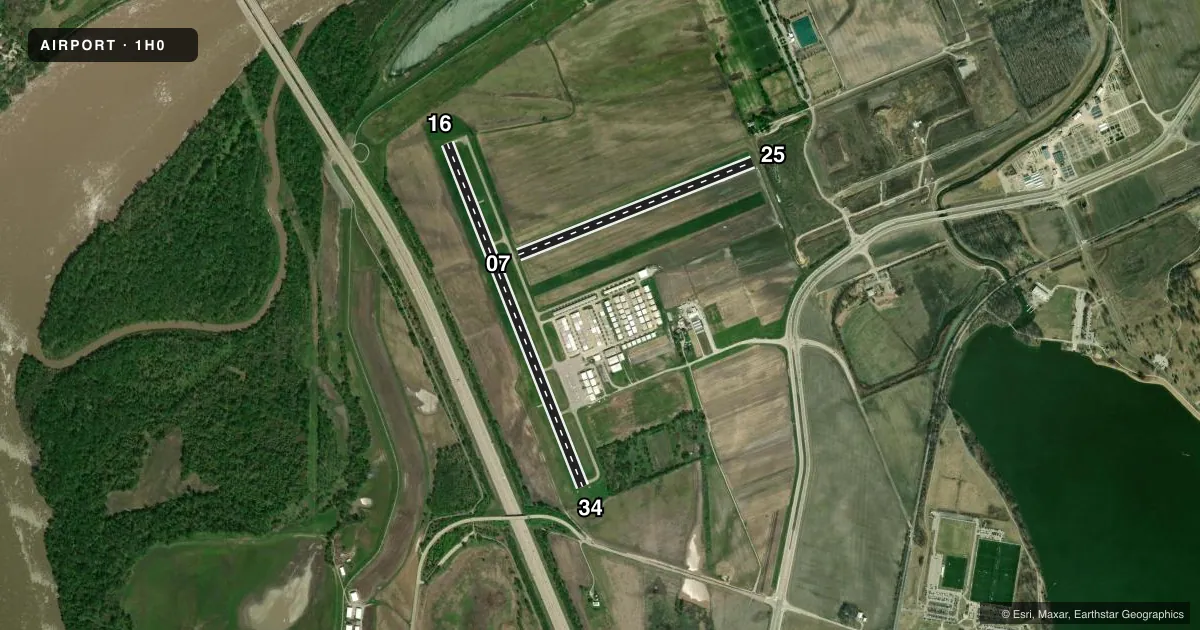
Runways & pattern
Full pagePattern entry · RWY 16
RIGHT TRAFFIC| Runway | Heading (°M) | Length | Surface | Traffic |
|---|---|---|---|---|
| 16/34 | 158° / 338° | 4,500 ft | CONC | 16 R |
| 07/25 | 68° / 248° | 3,079 ft | TURF | 25 R |
Runway end performance
| End | TORA | TODA | ASDA | LDA | VGSI | Approach lights | Obstruction |
|---|---|---|---|---|---|---|---|
| 16 | — | — | — | — | PAPI 4-box left(3°) | — | — |
| 34 | — | — | — | — | PAPI 4-box left(3°) | — | — |
Declared distances in feet. TORA = takeoff run available, TODA = takeoff distance, ASDA = accelerate-stop, LDA = landing distance.
Airport sketch
Runways drawn to scale from FAA survey coordinates, rendered over satellite imagery. Not for navigation.
Approaches & charts
Services on the field
Fuel grades, oxygen, maintenance, ramp storage and lighting — as declared to the FAA by the airport operator.
Fuel & services
- Fuel
- 100LLA
- Airframe repair
- Major
- Power plant repair
- Minor
- Other services
- INSTR,RNTL,SALES
Ramp & ground
- Transient storage
- Tie-down
- Hangar
- Landing fee
- No fee published
- Customs
- Not available
- Lighting schedule
- SEE RMK
- Beacon schedule
- SS-SR
- Beacon
- White / Green (civil land)(WG)
- Wind indicator
- Lighted
- Segmented circle
- Yes
Fuel & FBOs
Cheapest 100LL and Jet A on the field and nearby. Always confirm with the FBO before taxi.
Airport notes
Surface conditions, obstructions, local procedures, lighting outages and other notes published with each FAA cycle.
General notes
- ULTRALIGHT & TGL OPS NA.
- TWY & APRON STRENGTH - AMGR.
- HOP ON & INVOF ARPT; WKEND ANTIQUE ACFT OPS ON & INVOF ARPT.
- HOVER TAXI TRNG PARL RWY 07/25.
- DEER ON & INVOF ARPT.
- FOR CD CTC ST LOUIS APCH AT 314-890-1017.
Lighting notes
- SS-SR REIL 16 & 34; MIRL RWY 16/34 PRESET LOW INTST; INCR INTST - CTAF. ACTVT REIL RWY 16 & 34 - CTAF.
Runway surface & condition
- 16/3412500 LB MAX GWT OR LESS; PPR MORE THAN 12500 LB - AMGR.
Approach & departure obstructions
- 16FADED.
- 34FADED.
- 07YELLOW CONES.
- 25YELLOW CONES.
Other notes
- TPA 1000 FT AGL FOR ACFT OVR 12500 LBS.
VFR map & nearby airports
VFR sectional. Tap any ICAO chip to open that airport.
Key facts · 1H0
Answer card- ICAO
- 1H0
- Name
- CREVE COEUR
- Location
- ST LOUIS, MISSOURI
- Elevation
- 462.3 ft MSL
- Traffic pattern altitude
- 1,112.3 ft MSL (650 AGL)
- Control tower
- Non-towered (use CTAF)
- Total runways
- 2
- Longest runway
- 16/34 · 4,500 ft
- Published ILS approaches
- 0
- Published frequencies
- 4
- Magnetic variation
- 0°
- Current flight rules
- VFR
- Current wind
- 000° at 0 kt
- Favored runway now
- –
Creve Coeur Airport sits in St Louis, Missouri. Field elevation is 462.3 ft MSL. The airport has two runways. The longest is runway 16/34 at 4,500 ft on concrete. Runway 07/25 is 3,079 ft of turf. There is no control tower. CTAF and UNICOM are both 122.8. Approach and departure service is on 126.5 or 254.3 through Saint Louis. No ILS approaches are published here.
Pattern altitude is 650 ft AGL, which is 1,112.3 ft MSL. The published remarks matter here. Deer are on and near the airport. Hopper operations are also in the area. Weekend antique aircraft operations are part of the local traffic picture. Ultralight and touch-and-go landing operations are not authorized. If you are flying an aircraft over 12,500 lb, the pattern altitude is 1,000 ft AGL. Runway 34 markings are faded. Yellow cones mark the ends of runways 07 and 25.
Creve Coeur Airport has one on-field FBO. Creve Coeur Airport carries AVGAS 100LL and Jet A with Prist. For clearance delivery, contact St Louis Approach at 314-890-1017. The field also notes that runway and apron strength information is available from the airport manager. If you are planning a heavier arrival, check the weight limits and get approval first.