METAR & TAF KSTL
Current METAR
Observed 10:51Z
KSTL 271051Z COR 15012KT 10SM FEW050 BKN150 28/24 A2993 RMK AO2 SLP118 T02830244
- Wind
- 150° @ 12 kt
- Visibility
- 10 SM
- Temp / Dew
- 28°C / 24°C
- Altimeter
- 29.93 inHg
- Clouds
- BKN
- Density alt
- 2,313 ft
- Ceiling
- 15,000 ft AGL
- Rules
- VFR
Airport info & contacts
Manager on record, flight service, ARTCC, attendance schedule and pattern altitude — published by the FAA and refreshed every 28 days.
Location
- From city
- 10 NM NW
- VFR sectional
- ST LOUIS
- ARTCC
- ZKC · KANSAS CITY
- NOTAM facility
- STL (NOTAM-D)
Airport manager
- Name
- MS. RHONDA HAMM-NIEBRUEGGE
- Phone
- 314-426-8000
- Address
- BOX 10212, ST LOUIS MO 63145
Flight service · Hours
- FSS STL
- SAINT LOUIS1-800-WX-BRIEF
- Attendance
- ALL
Frequencies
Tap any row to copy the frequency to your clipboard.
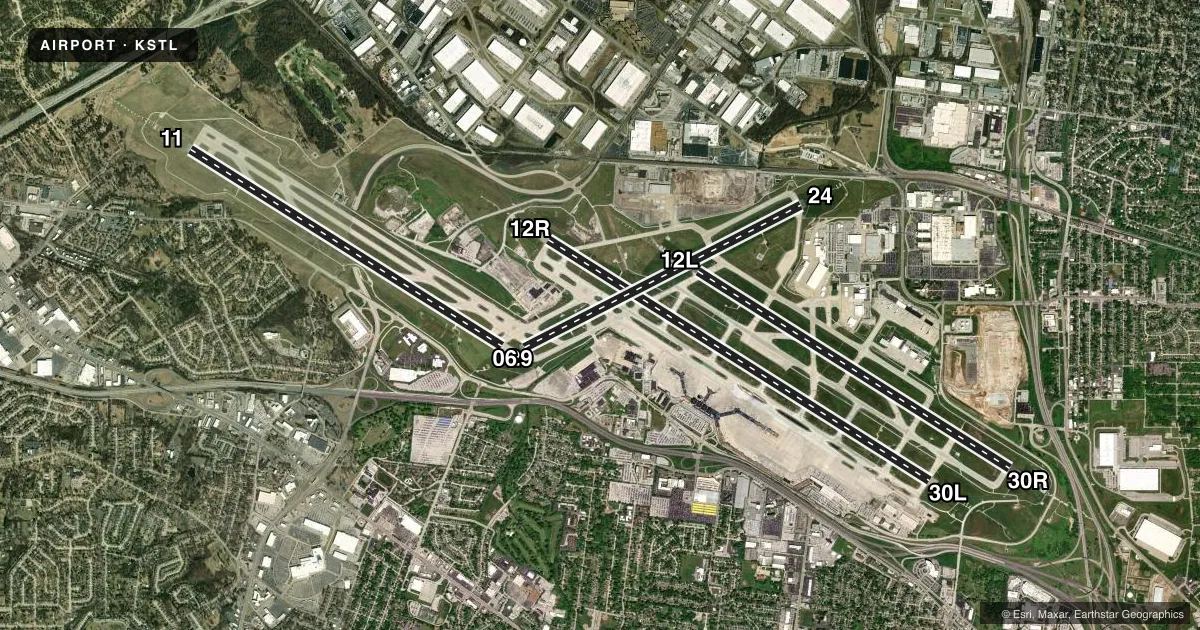
Runways & pattern
Full pagePattern entry · RWY 12R
RIGHT TRAFFIC| Runway | Heading (°M) | Length | Surface | Traffic |
|---|---|---|---|---|
| 12R/30LFavored | 121° / 301° | 11,020 ft | CONC | 12R R |
| 12L/30R | 121° / 301° | 9,013 ft | CONC | 30R R |
| 11/29 | 121° / 301° | 9,000 ft | CONC | 11 R |
| 06/24 | 62° / 242° | 7,603 ft | CONC | Standard L |
Runway end performance
| End | TORA | TODA | ASDA | LDA | VGSI | Approach lights | Obstruction |
|---|---|---|---|---|---|---|---|
| 12R | 11,020' | 11,020' | 11,020' | 10,553' | PAPI 4-box left(3°) | MALSR | 119', tree, 3213' from thr, 773' R of cntrln, slope 27 |
| 30L | 11,020' | 11,020' | 10,880' | 10,679' | PAPI 4-box right(3°) | MALSR | 99', tree, 2895' from thr, 547' R of cntrln, slope 29 |
| 12L | 9,013' | 9,013' | 8,956' | 8,956' | PAPI 4-box right(3°) | ALSF2 | 132', tree, 4870' from thr, 408' R of cntrln, slope 37 |
| 30R | 9,013' | 9,013' | 9,013' | 9,013' | PAPI 4-box right(3°) | ALSF2 | 52', tree, 1732' from thr, 612' R of cntrln, slope 33 |
| 11 | 9,000' | 9,000' | 9,000' | 9,000' | PAPI 4-box right(3°) | ALSF2 | — |
| 29 | 9,000' | 9,000' | 9,000' | 9,000' | PAPI 4-box left(3°) | ALSF2 | 121', tree, 3218' from thr, 860' R of cntrln, slope 25 |
| 06 | 7,603' | 7,603' | 7,323' | 7,323' | PAPI 4-box right(3°) | MALSR | 110', tree, 3077' from thr, 505' R of cntrln, slope 27 |
| 24 | 7,603' | 7,603' | 7,603' | 7,603' | PAPI 4-box left(3°) | MALS | 18', sign, 750' from thr, 450' R of cntrln, slope 30 |
Declared distances in feet. TORA = takeoff run available, TODA = takeoff distance, ASDA = accelerate-stop, LDA = landing distance.
Airport sketch
Runways drawn to scale from FAA survey coordinates, rendered over satellite imagery. Not for navigation.
Approaches & charts
ILS · 8
Services on the field
Fuel grades, oxygen, maintenance, ramp storage and lighting — as declared to the FAA by the airport operator.
Fuel & services
- Fuel
- 100LLA
- Oxygen (bottled)
- HIGH/LOW
- Oxygen (bulk)
- HIGH/LOW
- Airframe repair
- Major
- Power plant repair
- Major
- Other services
- AFRT,AVNCS,CARGO,CHTR,INSTR,RNTL,SALES
Ramp & ground
- Transient storage
- Tie-down
- Hangar
- Landing fee
- Yes
- Customs
- Not available
- Beacon schedule
- SS-SR
- Beacon
- White / Green (civil land)(WG)
- Wind indicator
- Lighted
- Segmented circle
- No
Fuel & FBOs
Cheapest 100LL and Jet A on the field and nearby. Always confirm with the FBO before taxi.
Airport notes
Surface conditions, obstructions, local procedures, lighting outages and other notes published with each FAA cycle.
General notes
- WAIVER TO CONDUCT SIMUL APCHS TO PARL RYS SEPARATED BY 1,300 FT IN EFCT.
- WG TIP CLNC WITH GND VEH NOT ADQT ALG N SIDE OF MAIN TRML APN.
- A-GEAR: A-G ARE KEPT IN RECESSED POSN TIL REQ FOR USE. TWR MUST BE NOTIFIED AT LEAST 5 SEC PRIOR TO ENGAGEMENT SO THAT CABLE MAY BE RAISED.
- TWY DELTA OR TAXILANE CHARLIE FM TWY SIERRA TO TWY GOLF, B-747S ARE NOT AUTH TO PASS OR BE PASSED BY B767 OR OTR LRGR ACFT OPRG ON THE PARL TWY/TAXILANE.
- TWY NOVEMBER BTN RWY 24 AND FOXTROT, RSTRD TO ACFT WITH A WINGSPAN OF LESS THAN 79 FT (CRJ-900 OR SMLR) WHEN ACFT ARE PARKED ON THE NOVEMBER PAD. THIS AREA IS RSTRD TO ALL OPNS WHEN ACFT ARE PERFORMING END RUN-UPS IN THE NOVEMBER PAD.
- TWY VICTOR, UNDERLYING THE RWY 12L FNA CRS, IS RSTRD TO ACFT WITH A TAIL HGT OF 25 FT OR LESS (CRJ-700 OR SMLR) WHEN ACFT ARE LNDG ON RWY 12L.
- TWY ALPHA EAST OF TWY TANGO, TWY SIERRA AND RWY 6/24 SOUTH OF TWY BRAVO, NO ACFT OR VEHICLE OPNS WHEN ARRIVING OR DEPG RWY 11 OR ARRIVING RWY 29.
- TWY LIMA, NORTH OF RWY 12L/30R, ACFT LRGR THAN A GULFSTREAM VI TAX NBND ARE PROHIBITED FM MAKING A RIGHT TURN EBND ON TWY FOXTROT.
- TWY VICTOR 2 IS UNAVBL TO B-767 OR LRGR ACFT (WINGSPAN 118 FT OR GTR).
- TWY VICTOR 2, B-737 (WINGSPAN GTR THAN 79 FT BUT LESS THAN 118 FT) MUST PERFORM JUDGMENTAL OVERSTEERING INSTEAD OF COCKPIT OVR CNTRLN STEERING WHEN TAX.
- TWY KILO 1 IS UNAVBL TO B-767 OR LRGR ACFT (WINGSPAN 118 FT OR GTR).
- TWY ECHO, BTN TWY NOVEMBER AND TWY LIMA RSTRD TO B-767 OR SMLR ACFT (WINGSPAN LESS THAN 171 FT) WHEN ACFT ARE PARKED ON THE ECHO PAD.
- TWY CHARLIE, FM TWY SIERRA TO TWY CHARLIE SEVEN, RSTRD TO B-767 OR SMLR ACFT (156 FT AVBL) WHEN ACFT ARE PARKED IN THE CHARLIE PAD. RSTRN IS FOR TAX ACFT, LRGR ACFT MAY BE TOWED THRU AREA.
- TWY CHARLIE, FROM TWY CHARLIE SEVEN TO TWY CHARLIE SIX, RSTRD TO A B757-300 SERIES OR SMLR.
- TXL CHARLIE, EAST OF TWY CHARLIE 2 TO TWY G, RSTRD TO B-737 OR SMLR ACFT (WINGSPAN LESS THAN 118 FT) WHEN ACFT ARE PARKED ON THE HOTEL PAD.
- TXL CHARLIE, FROM TWY CHARLIE SIX TO TWY CHARLIE FOUR, RSTRD TO B757-300 SERIES OR SMLR WHEN PASSING BHND ACFT THAT HAVE MADE THE INITIAL 10 FT PUSHBACK.
- CONNECTING ISLANDS CUTTING TWY S IN HALF BTN TWY D AND TWY C AND ADDING TWY C8.
Fuel notes
- AJET-A
Runway surface & condition
- 06/24RUNWAY LOAD CAPACITY: ST175
- 12L/30RRUNWAY LOAD CAPACITY: ST175
- 12R/30LRUNWAY LOAD CAPACITY: ST175
- 06/24PCR VALUE: 600/R/D/W/T
- 11/29PCR VALUE: 1100/R/D/W/T
- 12L/30RPCR VALUE: 1410/R/D/W/T
- 12R/30LPCR VALUE: 905/R/D/W/T
Approach & departure obstructions
- 12RAPCH RATIO FM DSPLCD THR 25:1.
- 30LAPCH RATIO FM DSPLCD THR 34:1.
Arresting gear
- 06_BAK-12BBAK-14 BAK -12B(B) (1450')
- 12R_BAK-12BBAK-14 BAK -12B(B) (1090')
- 30L_BAK-12BBAK-14 BAK -12B(B) (1300')
Other notes
- LNDG FEE BASED ON ACFT WEIGHT COLLECTED BY FBO.
- MANAGERDELIVERIES GOTO: 10701 LAMBERT INTERNATIONAL BLVD.
- OWNERCITY HALL
- MANAGERAIRPORT DIRECTOR
VFR map & nearby airports
VFR sectional. Tap any ICAO chip to open that airport.
Key facts · KSTL
Answer card- ICAO
- KSTL
- Name
- ST LOUIS LAMBERT INTL
- Location
- ST LOUIS, MISSOURI
- Elevation
- 617.3 ft MSL
- Traffic pattern altitude
- 1,617.3 ft MSL (1,000 AGL)
- Control tower
- Towered · 24
- Total runways
- 4
- Longest runway
- 12R/30L · 11,020 ft
- Published ILS approaches
- 8
- Published frequencies
- 32
- Magnetic variation
- 1°
- Current flight rules
- VFR
- Current wind
- 150° at 12 kt
- Favored runway now
- RWY 12R
KSTL is in St Louis, Missouri. Field elevation is 617.3 ft MSL. The airport has 4 runways. The longest is 11,020 ft on 12R/30L. The tower is open 24 hours. Eight ILS approaches are published for runway ends 06, 11, 12L, 12R, 24, 29, 30L and 30R.
Pattern altitude is not published in the facts. Use the current FAA Chart Supplement before arrival. Signature Aviation is on the field. It carries 100LL and Jet A. Call (314) 731-7111 for current ramp and fuel details. Published remarks also note that landing fees based on aircraft weight are collected by the FBO.
This is busy Class B airspace. Expect a high-workload arrival and close attention to ATC instructions. The field also has taxiway restrictions tied to large aircraft movement. That matters if you are arriving behind airline traffic or taxiing near the Charlie and Echo pads. Runway 12R has a published displaced-threshold approach ratio note. Check the current Chart Supplement for any noise or operational updates before flying in.