METAR & TAF KCPS
Current METAR
Observed 09:53Z
KCPS 260953Z AUTO 00000KT 8SM CLR 24/24 A2992 RMK AO2 SLP126 T02390239 $
- Wind
- 000° @ 0 kt
- Visibility
- 8 SM
- Temp / Dew
- 24°C / 24°C
- Altimeter
- 29.92 inHg
- Clouds
- CLR
- Density alt
- 1,592 ft
- Ceiling
- Unlimited
- Rules
- VFR
Airport info & contacts
Manager on record, flight service, ARTCC, attendance schedule and pattern altitude — published by the FAA and refreshed every 28 days.
Location
- From city
- 1 NM E
- VFR sectional
- ST LOUIS
- ARTCC
- ZKC · KANSAS CITY
- NOTAM facility
- CPS (NOTAM-D)
Airport manager
- Name
- SANDRA SHORE
- Phone
- 618-337-6060
- Address
- 6100 ARCHVIEW DRIVE, CAHOKIA IL 62206-1445
Flight service · Hours
- FSS STL
- SAINT LOUIS1-800-WX-BRIEF
- Attendance
- ALL
Frequencies
Tap any row to copy the frequency to your clipboard.
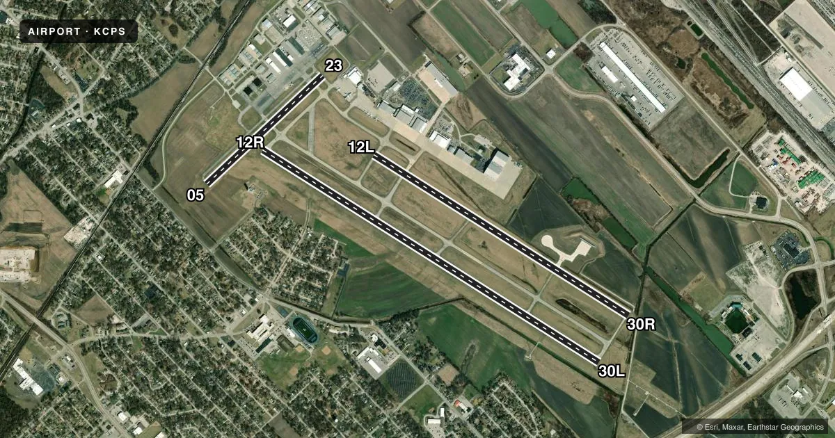
Runways & pattern
Full pagePattern entry · RWY 12R
RIGHT TRAFFIC| Runway | Heading (°M) | Length | Surface | Traffic |
|---|---|---|---|---|
| 12R/30L | 122° / 302° | 7,002 ft | ASPH | 12R R |
| 12L/30R | 122° / 302° | 5,301 ft | CONC | 30R R |
| 05/23 | 47° / 227° | 2,799 ft | ASPH | Standard L |
Runway end performance
| End | TORA | TODA | ASDA | LDA | VGSI | Approach lights | Obstruction |
|---|---|---|---|---|---|---|---|
| 12R | 7,002' | 7,002' | 7,002' | 7,002' | PAPI 4-box left(3°) | — | 30', tree, 809' from thr, 487' R of cntrln, slope 20 |
| 30L | 7,002' | 7,002' | 7,002' | 7,002' | PAPI 4-box left(3°) | MALSR | 29', pole, 1688' from thr, 362' R of cntrln, slope 36 |
| 12L | 5,300' | 5,300' | 5,300' | 5,300' | — | — | 96', tree, 3817' from thr, 254' R of cntrln, slope 37 |
| 30R | 5,300' | 5,300' | 5,300' | 5,300' | — | — | 72', tree, 2664' from thr, 306' R of cntrln, slope 34 |
| 05 | 2,799' | 2,799' | 2,799' | 2,799' | — | — | 54', tree, 811' from thr, 58' R of cntrln, slope 11 |
| 23 | 2,799' | 2,799' | 2,799' | 2,799' | — | — | 72', tower, 1647' from thr, 16' R of cntrln, slope 20 |
Declared distances in feet. TORA = takeoff run available, TODA = takeoff distance, ASDA = accelerate-stop, LDA = landing distance.
Airport sketch
Runways drawn to scale from FAA survey coordinates, rendered over satellite imagery. Not for navigation.
Approaches & charts
ILS · 1
Services on the field
Fuel grades, oxygen, maintenance, ramp storage and lighting — as declared to the FAA by the airport operator.
Fuel & services
- Fuel
- 100LLA
- Oxygen (bulk)
- High pressure
- Airframe repair
- Major
- Power plant repair
- Major
- Other services
- CHTR,INSTR,RNTL,SALES
Ramp & ground
- Transient storage
- Tie-down
- Hangar
- Landing fee
- No fee published
- Customs
- Not available
- Lighting schedule
- SEE RMK
- Beacon schedule
- SS-SR
- Beacon
- White / Green (civil land)(WG)
- Wind indicator
- Lighted
- Segmented circle
- Yes
Fuel & FBOs
Cheapest 100LL and Jet A on the field and nearby. Always confirm with the FBO before taxi.
Airport notes
Surface conditions, obstructions, local procedures, lighting outages and other notes published with each FAA cycle.
General notes
- WATERFOWL ON & INVOF ARPT.
- BE ALERT FOR STUDENT TRNG & HEL OPS.
- ALL TWYS EXCP TWY B4 PPR ACFT OVER 120000 LBS.
- SFC CONDS NOT MNTD 2100-0700 LCL.
Lighting notes
- ACTVT MALSR RWY 30L WHEN ATCT CLSD; REIL RWY 30R - CTAF. HIRL RWY 12R/30L PRESET MED INTST WHEN ATCT CLSD. MIRL RWY 12L & 30R NOT AVBL WHEN ATCT CLSD. PAPI RWY 12R & 30L OPR CONSLY.
Runway surface & condition
- 12R/30L200 WITH PPR.
- 12R/30LPCR VALUE: 400/F/D/X/T
- 05/23RWY 05/23 NOT AVBL FOR PART 121/PART 380 OPS WITH SKED PAX CARRYING OPS MORE THAN 9 PAX SEATS AND NON-SKED PAX CARRYING OPS MORE THAN 30 PAX SEATS. NO PART 121/PART 380 OPS EXC FOR TAX.
- 12L/30RRWY 12L/30R NOT AVBL FOR PART 121/PART 380 OPS WITH SKED PAX CARRYING OPS MORE THAN 9 PAX SEATS AND NON-SKED PAX CARRYING OPS MORE THAN 30 PAX SEATS. NO PART 121/PART 380 OPS EXC FOR TAX.
- 12R/30LW.B.C. GROSS WT (2S) 160.
Approach & departure obstructions
- 05SFC MARKINGS FADED.
- 23SFC MARKINGS FADED.
Other notes
- CLSD TO SKED ACR OPS GTR THAN 9 PSGR SEATS. UNSKED ACR OPS GTR THAN 30 PSGR SEATS RQR 12 HR PPR.
VFR map & nearby airports
VFR sectional. Tap any ICAO chip to open that airport.
Key facts · KCPS
Answer card- ICAO
- KCPS
- Name
- ST LOUIS DOWNTOWN
- Location
- CAHOKIA/ST LOUIS, ILLINOIS
- Elevation
- 412.9 ft MSL
- Traffic pattern altitude
- 1,412.9 ft MSL (1,000 AGL)
- Control tower
- Towered · 0630-2200
- Total runways
- 3
- Longest runway
- 12R/30L · 7,002 ft
- Published ILS approaches
- 1
- Published frequencies
- 10
- Magnetic variation
- 0°
- Current flight rules
- VFR
- Current wind
- 000° at 0 kt
- Favored runway now
- –
St Louis Downtown Airport (KCPS) sits in Cahokia, Illinois, across the river from St. Louis. Field elevation is 412.9 ft MSL. The airport has three runways. The longest is 12R/30L at 7,002 ft. The field is towered from 0630 to 2200 local. One ILS is published for runway 30L.
Pattern altitude is not published in the facts. Use the standard 1,000 ft AGL for light piston traffic unless the current Chart Supplement says otherwise. Jet Aviation St. Louis is on the field. It carries 100LL, Jet A and Jet A Prist. Call (618) 646-8263 for current service details.
Plan for a busy training environment. The published remarks call out student traffic and helicopter operations. Waterfowl are also present on and near the airport. Runway 12L/30R and runway 05/23 have published restrictions for larger passenger operations. Runway 23 has faded surface markings. When the tower is closed, runway lighting changes on 30L and 30R. Review the current lighting setup before a night arrival. Surface conditions are not maintained from 2100 to 0700 local time. Check the current FAA Chart Supplement for any noise or curfew restrictions before flying into the field.