METAR & TAF KBLV
Current METAR
Observed 13:55Z
KBLV 271355Z AUTO 22011KT 10SM CLR 28/22 A2993 RMK AO2 SLP133 T02790216 $
- Wind
- 220° @ 11 kt
- Visibility
- 10 SM
- Temp / Dew
- 28°C / 22°C
- Altimeter
- 29.93 inHg
- Clouds
- CLR
- Density alt
- 2,117 ft
- Ceiling
- Unlimited
- Rules
- VFR
Airport info & contacts
Manager on record, flight service, ARTCC, attendance schedule and pattern altitude — published by the FAA and refreshed every 28 days.
Location
- From city
- 14 NM E
- VFR sectional
- ST LOUIS
- ARTCC
- ZKC · KANSAS CITY
- NOTAM facility
- BLV (NOTAM-D)
Airport manager
- Name
- DARREN V. JAMES
- Phone
- 618-566-5240
- Address
- 9656 AIR TERMINAL DR, STE 250, MASCOUTAH IL 62258-5501
Flight service · Hours
- FSS STL
- SAINT LOUIS1-800-WX-BRIEF
- Attendance
- ALL
Frequencies
Tap any row to copy the frequency to your clipboard.
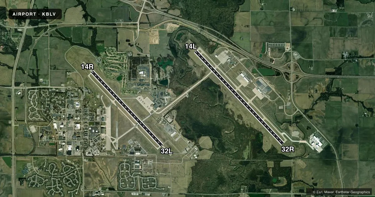
Runways & pattern
Full pagePattern entry · RWY 14L
LEFT TRAFFIC| Runway | Heading (°M) | Length | Surface | Traffic |
|---|---|---|---|---|
| 14L/32RFavored | 135° / 315° | 10,000 ft | CONC | 32R R |
| 14R/32L | 135° / 315° | 8,006 ft | ASPH-CONC | 14R R |
Runway end performance
| End | TORA | TODA | ASDA | LDA | VGSI | Approach lights | Obstruction |
|---|---|---|---|---|---|---|---|
| 14L | 10,000' | 10,000' | 10,000' | 10,000' | PAPI 4-box right(3°) | — | — |
| 32R | 10,000' | 10,000' | 10,000' | 10,000' | PAPI 4-box left(3°) | MALSR | — |
| 14R | — | — | — | — | PAPI 4-box left(3°) | ALSF1 | — |
| 32L | — | — | — | — | PAPI 4-box left(3°) | ALSF1 | — |
Declared distances in feet. TORA = takeoff run available, TODA = takeoff distance, ASDA = accelerate-stop, LDA = landing distance.
Airport sketch
Runways drawn to scale from FAA survey coordinates, rendered over satellite imagery. Not for navigation.
Approaches & charts
ILS · 4
Services on the field
Fuel grades, oxygen, maintenance, ramp storage and lighting — as declared to the FAA by the airport operator.
Fuel & services
- Fuel
- 100LLA+
- Oxygen (bottled)
- Not available
- Airframe repair
- Not available
- Other services
- AFRT,CARGO,CHTR
Ramp & ground
- Transient storage
- Tie-down
- Landing fee
- Yes
- Customs
- Not available
- Beacon schedule
- SS-SR
- Beacon
- White / Green (civil land)(WG)
- Wind indicator
- Yes
- Segmented circle
- No
Fuel & FBOs
Cheapest 100LL and Jet A on the field and nearby. Always confirm with the FBO before taxi.
Airport notes
Surface conditions, obstructions, local procedures, lighting outages and other notes published with each FAA cycle.
General notes
- SAFB IS UNSUITABLE FOR HAZARDOUS CARGO WITHOUT PRIOR COORDINATION AND SHOULD NOT BE CONSIDERED A ROUTINE LOCATION FOR MISSIONS CARRYING HAZARDOUS CARGO.
- SAFB AIRFIELD OPERATIONS OPEN 24/7.
- TRANSIENT MIL ACFT PARKING ON CIVILLIAN RAMPS CONTACT MIDAMERICA ON 618-566-5265 OR 618-566-5227 FOR AVBL SVCS & PARKING INFO.
- DEER, BIRDS & WATERFOWL ON & INVOF ARPT.
- JASU: SCOTT AFB 6(A/M32A-86) 3(AM32-95). MIDAMERICA 2 (A/M 32A-60B) 1 (AM32-95) 2 (A/M 32A-86) 1 (MD-4).
- CIV ACFT FUEL: A+ 100LL (AGI GROUND, AVBL 1400-0200Z++, C618-566-5265.)
- FLUID: SCOTT AFB SP(MIL) PRESAIR(MIL) LHOX(MIL) LOX(MIL).
- OIL: SCOTT AFB O-133-148(MIL) SOAP(MIL)
- TRAN ALERT SCOTT AFB: OPR 1200-0400Z++ WKD; 1400-2300Z++ WKEND; CLSD FEDERAL HOL. MILITARY SVC AT MIDAMERICA (CIVILIAN SIDE) OPR 1400-0200Z++, 24 HR PPR OT. FBO MILITARY SVC LTD TO REFUELING (DLA CONTRACT) AND DE-ICING. CTC FBO AT C618-566-5265 FOR SPECIFIC PRK AND SVC.
- MILITARY USE: SEE FLIP AP/1 SUPPLEMENTARY REMARKS.
- SAFB PPR DSN 576-1861, C618-256-1861. ALL INBD PAX/CARGO ACFT MUST CTC 375 COMD POST NO LATER THAN 30 MIN PRIOR TO LDG. AMC ACFT RSTD DUR BASH PHASEII AND WHEN ARPT ENTERS BIRD WATCH CONDITIONS MODERATE OR SEVERE.
- SCOTT AFB RSTD: WHEN ARPT IS CODE MODERATE OR SEVER NO LCL IFR/VFR PAT. WHEN ARPT CODE SEVER, TKOF/LDG PROH WO 375 OG/CC APVL. DUR PHASEII, DLY BASH WINDOWS ARE ESTIMATED AS SR+1-SR-1 AND SS+1, SS-1.
- SCOTT AFB RSTD: DUR BASH WINDOW (WHEN CODE LOW) NO TRANS PAT PERMS; INITIAL TKOF/FULL STOP LDG ARE AT AC DISCRETION. CTC ATIS, PTD, 375 AW COMD POST OR TWR FOR CURRENT CODE.
- DENSE CIV AIR TFC ALL QUAD, ALL ALT. USE CAUTION WHEN UTILIZING TWY G, 0.25 NM E OF RY 14R-32L INT, GRAD CHG OF 3 DEG AND A 70 DEG TURN PRESENT, ON COMING TFC MAY NOT BE VIS DUE TO TERRAIN.
- RSTD; SCOTT AFB IS PPR. THE 375 MIL FLIGHT SVC SECTION IS THE SOLE AGENT FOR ISSUING PPR NRS TO MIL ACFT OPRG ON OR FM THE SCOTT AFB SIDE.
- MIL RAMPS CLSD TO CIVIL ACFT WITHOUTPRIOR COORDINATION AND A LANDING PERMIT NR ON FILE.
- PARKING AT THE 126 ARW RAMP IS OFFICIAL BUSINESS ONLY REQUIRING 48 HRS PPR. PPR CALL DSN 760-9977, C 618-229-9977, OR 126TH CP C 618-229-9060.
- ALL INBOUND ACFT ARRIVING SCOTT AFB MUST CTC 375 COMD POST OR 126TH ANG COMD POST NO LATER THAN 30 MIN PRIOR TO LDG.
- ACFT ARRIVING SCOTT AFB WITH MORE THAN 30 PSGR AFTER HRS CTC BASE OPS 24 HRS IN ADVANCE C618-256-1861.
- MIL SUPPORT FROM SAFB MAY NOT BE AVBL ON MIDAMERICA SIDE OF FLD WO PRIOR COORD THRU SCOTT AFB. PPR ISSUED UP TO 7 DAYS PRIOR TO ARR.
- RSTD: FULL WX SVC AVBL H24. COMBAT WX FLIGHT DSN 576-3663, C618-256-3663. BLDG OBST MAY IMPACT PREVAILING VIS 200-320 DEG. ATC WILL ENHANCE SFC OBSN WHEN TWR IS LESS THAN 4 SM AND DIFFERENT THAN RPT VIS.REMOTE BRIEFING SVC AVBL FROM 15 OPERATIONAL SQUADRON, DSN 576-9755, C618-256-9755.
- CIVILIAN FBO AVBL 1200-2030Z++, C618-566-5265.
- LTD DEICING CPBLTY. ACFT CMDRS MUS COORD WITH SAFB COMD POST DSN 576-5891, C618-256-5891 FOR AVAIL AT LEAST 24 HR PRIOR TO DEP.
- SERVICE-FUEL: A++(MIL). SCOTT AFB FUEL SVC AVBL 1100Z-0500Z, OT RQR 1 HR PN.
- MISC: EACH RWY HAS DIFFERENT LEVELS OF ARFF SUPPORT. CONSIDER RWY 14L-32R A CIV AIRPORT PROVIDING FAA INDEX B SUPPORT FOR CIV ACFT. STEADY ARFF COND FOR RWY 14R/32L IS OPTIMUM LEVEL OF SVC (OLS) FOR CATS 1-6, REDUCED LEVEL OF SVC (RLS) FOR CATS 7-8, AND CRITICAL LEVEL OF SVC (CLS) FOR CATS 9-10, 0001-2359++ DLY.
- TWY H CLSD.
- H24 WX SVC AVBL AT DSN 576-5905, C618-256-5905. AN/FMQ-19 AUTOMATED OBSERVING SYS IN USE; AUGMENTED BY HUMAN OBSN WHEN NEC. IF WX FLT UNAVBL, REMOTE SVC AVBL FR 15 OPR WX SQUADRON DSN 576-9755, C618-256-9755.
- CAUTION: UNEXP BUMPS OCCURRING ON TWY G BTN RWYS WHEN CROS BRIDGES AND TUNNELS. USE MIN SPEEDS WHEN OPR IN THE AREA.
- MISC: ACARS AVBL.
- SERVICE-TRAN ALERT: HOT PIT REFUL AVBL TO CERTAIN ACFT WITH 3 HR PN AND MAX OF 2 AT A TIME.
- CTC 375 AMW COMD POST 20 MIN PRIOR TO ARR FOR HOT PIT REQ.
- ACFT WITH WINGSPANS MORE THAN 170' ARE PROHIBITED FM TXG ON SCOTT MAIN RAMP TAXI LANE WO AFLD MGMT APVL.
- CUST/AG/IMG - CUST AVBL. CTC BASE OPS 72 HRS PRIOR TO EXP ARR TO COORD. CIV ACFT MUST BE CLEARED BY US CUST IF GIVEN A MIN 72 HR NTC PRIOR TO ACFT ARR.
- MISC: RWY 14L WINDS EST.
- REMARKS: O/S UFN. CTC TWR OR WX FOR MORE INFO.
- TRAIN TRACK LCTD APRX 1650 FT FROM DTHR OF RWY 32L; RWY 32L APCH LGT INTERRUPTED BY PASSING TRAIN.
- SMALL UAS (SUAS) OPR CLASS D AIRSPACE SFC TO 400 FT AGL.
- MIL ACFT: RWY 32L 1000 FT OVRN AVBL; RWY 14R 1000 FT OVRN AVBL.
Runway surface & condition
- 14L/32RPCR VALUE: 870/R/B/W/T
- 14R/32LHAS 1000 FT OVRN BOTH ENDS.
Other notes
- ARFF INDEX C AVBL WITH 72 HRS PRIOR NOTICE 618-566-5233.
- LNDG FEE (N/A FOR MIL AIRCRAFT).
- TFC PAT: OVHD, FTR ACFT, 2500 FT; RECTANGULAR 2000 FT; LGT ACFT AND COPTER RECTANGULAR 1500 FT. DURG VFR COND; TKOF, LOW APCH, TOUCH AND GO AND CLSD PAT, ACFT WILL NOT EXCEED 2000 FT TIL FLD BDRY TO AVOID OVHD PAT.
- MANAGER375AMW SCOTT AFB BELLEVILLE IL 62225
- OWNER375AMW SCOTT AFB BELLEVILLE IL 62225.
- MANAGERUSAF BASE OPERATION 618-256-1861/KEITH WOLFE 618-256-4101.
- 14R/32LMISC: FIRST 6000 FT OF RWY 32L IS ASPH, REMAINING 2006 FT IS CONC; LOCKED WHEEL TURNS ON ASPH PORTION OF RWY PROHIBITED. 180 DEG TURNS ON ASPH PORTION OF RWY IS AUTHORIZED FOR LGT & MED CATAGORY ACFT ONLY.
VFR map & nearby airports
VFR sectional. Tap any ICAO chip to open that airport.
Key facts · KBLV
Answer card- ICAO
- KBLV
- Name
- SCOTT AFB/MIDAMERICA ST LOUIS
- Location
- BELLEVILLE, ILLINOIS
- Elevation
- 459.1 ft MSL
- Traffic pattern altitude
- 1,459.1 ft MSL (1,000 AGL)
- Control tower
- Towered · 24
- Total runways
- 2
- Longest runway
- 14L/32R · 10,000 ft
- Published ILS approaches
- 4
- Published frequencies
- 16
- Magnetic variation
- 2°
- Current flight rules
- VFR
- Current wind
- 220° at 11 kt
- Favored runway now
- RWY 14L
KBLV is in Belleville, Illinois, serving the Scott Air Force Base and MidAmerica St. Louis field. Field elevation is 459.1 ft MSL. The airport has 2 runways. The longest is 14L/32R at 10,000 ft. The tower is open 24 hours. There are 4 ILS approaches available to the runway ends. Pattern altitude is not published in the facts, so use the current FAA Chart Supplement before you go. For light piston traffic, plan on the standard 1,000 ft AGL pattern unless you confirm otherwise.
This is a military field with civilian-side operations, so read the current remarks closely before arrival. Taxiway H is closed. Transient military aircraft parking on civilian ramps requires you to contact MidAmerica for parking and service details. Outside service is listed as available until further notice. Limited deicing capability is published, so call ahead if you may need it. The field also notes that airport code restrictions can suspend local IFR or VFR pattern work during moderate or severe conditions. If you are planning a first stop here, expect a busy controlled environment and verify current procedures with the tower or the airport operator before launch.