METAR & TAF KALN
Current METAR
Observed 16:50Z
KALN 271650Z 22012KT 10SM CLR 33/22 A2986
- Wind
- 220° @ 12 kt
- Visibility
- 10 SM
- Temp / Dew
- 33°C / 22°C
- Altimeter
- 29.86 inHg
- Clouds
- CLR
- Density alt
- 2,908 ft
- Ceiling
- Unlimited
- Rules
- VFR
Airport info & contacts
Manager on record, flight service, ARTCC, attendance schedule and pattern altitude — published by the FAA and refreshed every 28 days.
Location
- From city
- 4 NM E
- VFR sectional
- ST LOUIS
- ARTCC
- ZKC · KANSAS CITY
- NOTAM facility
- ALN (NOTAM-D)
Airport manager
- Name
- DANIEL ADAMS, AAE
- Phone
- 618-259-2531
- Address
- 8 TERMINAL DR, SUITE 1, EAST ALTON IL 62024
Flight service · Hours
- FSS STL
- SAINT LOUIS1-800-WX-BRIEF
- Attendance
- 0700-2200
Frequencies
Tap any row to copy the frequency to your clipboard.
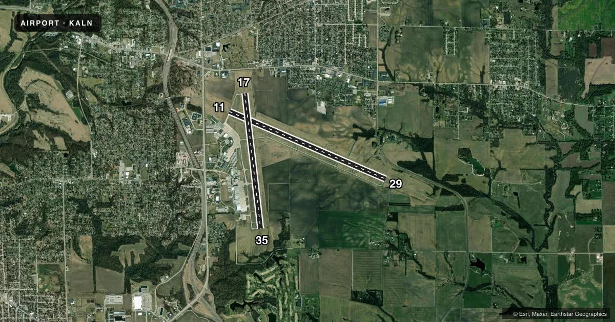
Runways & pattern
Full pagePattern entry · RWY 17
LEFT TRAFFIC| Runway | Heading (°M) | Length | Surface | Traffic |
|---|---|---|---|---|
| 11/29 | 112° / 292° | 8,099 ft | ASPH | Standard L |
| 17/35Favored | 172° / 352° | 6,500 ft | ASPH | Standard L |
Runway end performance
| End | TORA | TODA | ASDA | LDA | VGSI | Approach lights | Obstruction |
|---|---|---|---|---|---|---|---|
| 11 | 8,099' | 8,099' | 8,099' | 8,099' | PAPI 4-box right(3°) | — | 35', tree, 1275' from thr, 475' R of cntrln, slope 30 |
| 29 | 8,099' | 8,099' | 8,099' | 8,099' | — | MALSR | — |
| 17 | — | — | — | — | PAPI 4-box left(3°) | — | 18', tree, 896' from thr, 139' R of cntrln, slope 38 |
| 35 | — | — | — | — | PAPI 4-box left(3°) | — | 32', trees, 1379' from thr, 72' R of cntrln, slope 36 |
Declared distances in feet. TORA = takeoff run available, TODA = takeoff distance, ASDA = accelerate-stop, LDA = landing distance.
Airport sketch
Runways drawn to scale from FAA survey coordinates, rendered over satellite imagery. Not for navigation.
Approaches & charts
ILS · 1
Services on the field
Fuel grades, oxygen, maintenance, ramp storage and lighting — as declared to the FAA by the airport operator.
Fuel & services
- Fuel
- 100LLA
- Oxygen (bottled)
- High pressure
- Oxygen (bulk)
- High pressure
- Airframe repair
- Major
- Power plant repair
- Major
- Other services
- CHTR,INSTR,RNTL
Ramp & ground
- Transient storage
- Tie-down
- Hangar
- Landing fee
- No fee published
- Customs
- Not available
- Lighting schedule
- SEE RMK
- Beacon schedule
- SS-SR
- Beacon
- White / Green (civil land)(WG)
- Wind indicator
- Lighted
- Segmented circle
- No
Fuel & FBOs
Cheapest 100LL and Jet A on the field and nearby. Always confirm with the FBO before taxi.
Airport notes
Surface conditions, obstructions, local procedures, lighting outages and other notes published with each FAA cycle.
General notes
- RWY 11 & 17 APCH ENDS CLOSELY ALIGNED; VERIFY CORRECT COMPASS HDG PRIOR TO DEP.
- INDEX B FFR EQUIP AVBL WITH 30-MIN PPR.
- MIGRATORY BIRD ACTIVITY IN VICINITY OF ARPT SEPTEMBER THROUGH APRIL.
- WILDLIFE ON AND IN VICINITY OF AIRPORT
Lighting notes
- ACTVT MALSR RWY 29; REIL RWY 11 - CTAF. WHEN ATCT CLSD PAPI 11, 17, 35; HIRL RWY 11/29; MIRL RWY 17/35 PRESET ON LOW INTST, TO INCR INTST & ACTVT - CTAF.
Runway surface & condition
- 11/29PCR VALUE: 440/F/D/X/T
- 17/35PCR VALUE: 180/F/D/X/T
- 11/29RWY 11/29 NOT AVBL FOR PART 121/PART 380 OPS WITH SKED PAX CARRYING OPS MORE THAN 9 PAX SEATS AND NON-SKED PAX CARRYING OPS MORE THAN 30 PAX SEATS. 90 DAY PPR FOR UNSKED ACR OPS GTR THAN 30 PAX SEATS - CALL AMGR.
- 17/35RWY 17/35 NOT AVBL FOR PART 121/PART 380 OPS WITH SKED PAX CARRYING OPS MORE THAN 9 PAX SEATS AND NON-SKED PAX CARRYING OPS MORE THAN 30 PAX SEATS. 90 DAY PPR FOR UNSKED ACR OPS GTR THAN 30 PAX SEATS - CALL AMGR.
Other notes
- 1ATTENDANT AFT HR - CALL 618-259-3230 OR 258-1005.
VFR map & nearby airports
VFR sectional. Tap any ICAO chip to open that airport.
Key facts · KALN
Answer card- ICAO
- KALN
- Name
- ST LOUIS RGNL
- Location
- ALTON/ST LOUIS, ILLINOIS
- Elevation
- 543.5 ft MSL
- Traffic pattern altitude
- 1,543.5 ft MSL (1,000 AGL)
- Control tower
- Towered · 0700-2200
- Total runways
- 2
- Longest runway
- 11/29 · 8,099 ft
- Published ILS approaches
- 1
- Published frequencies
- 9
- Magnetic variation
- 1°
- Current flight rules
- VFR
- Current wind
- 220° at 12 kt
- Favored runway now
- RWY 17
ST LOUIS RGNL is in Alton, Illinois near the St. Louis area. Field elevation is 543.5 ft MSL. The airport has two asphalt runways. The longest is runway 11/29 at 8,099 ft. Runway 17/35 is 6,500 ft.
The field is towered. Tower hours are 0700-2200. One ILS is published for runway 29. Pattern altitude is not published, so use standard 1,000 ft AGL for light piston operations unless the current FAA Chart Supplement says otherwise. That puts the usual pattern reference at 1,543.5 ft MSL.
West Star Aviation is on the field. It carries 100LL and Jet A. The remarks also matter here. Runway 11/29 has a published pavement rating. Runway 17/35 and runway 11/29 both have restrictions for some large passenger operations. Wildlife is reported on and near the airport. Migratory bird activity is noted from September through April. If you arrive after hours, the published remarks give a phone number for attendant service. The lighting setup also uses CTAF to increase intensity when the tower is closed.
For a first-time arrival, pay attention to the runway alignment. Runway 11 and 17 approach ends are closely aligned. Verify the correct heading before departure. Check the current FAA Chart Supplement for any current noise, lighting, or operational notes before you go.