METAR & TAF 3LF
Current METAR
Observed 12:35Z
K3LF 271235Z AUTO 17010KT 10SM CLR 23/21 A2996 RMK AO2 T02340205
- Wind
- 170° @ 10 kt
- Visibility
- 10 SM
- Temp / Dew
- 23°C / 21°C
- Altimeter
- 29.96 inHg
- Clouds
- CLR
- Density alt
- 1,767 ft
- Ceiling
- Unlimited
- Rules
- VFR
Airport info & contacts
Manager on record, flight service, ARTCC, attendance schedule and pattern altitude — published by the FAA and refreshed every 28 days.
Location
- From city
- 2 NM SW
- VFR sectional
- ST LOUIS
- ARTCC
- ZKC · KANSAS CITY
- NOTAM facility
- 3LF (NOTAM-D)
Airport manager
- Name
- NICHOLAS WEATHERFORD
- Phone
- 217-556-4299
- Address
- 1201US ROUTE 66 SOUTH, P.O. BOX 381, LITCHFIELD IL 62056
Flight service · Hours
- FSS STL
- SAINT LOUIS1-800-WX-BRIEF
- Attendance
- 0800-1700
Frequencies
Tap any row to copy the frequency to your clipboard.
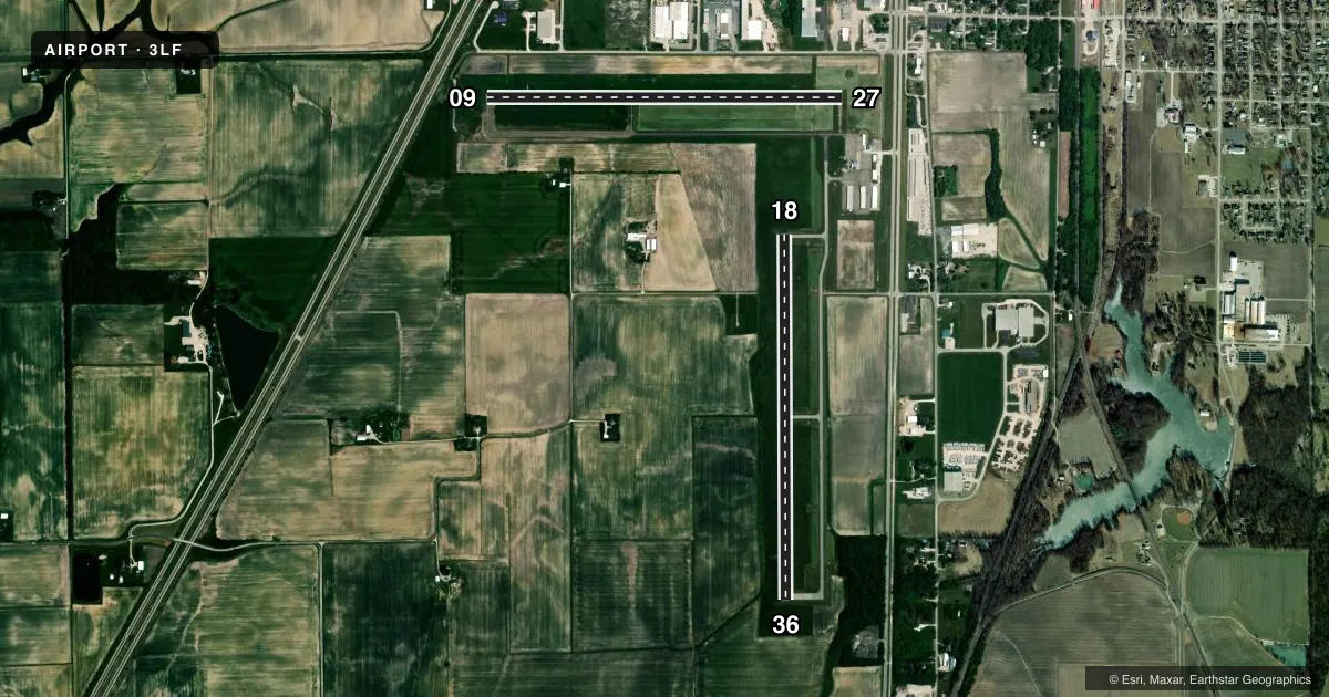
Runways & pattern
Full pagePattern entry · RWY 18
RIGHT TRAFFIC| Runway | Heading (°M) | Length | Surface | Traffic |
|---|---|---|---|---|
| 18/36Favored | 178° / 358° | 4,002 ft | ASPH | 18 R |
| 09/27 | 89° / 269° | 3,900 ft | ASPH | 09 R |
Runway end performance
| End | TORA | TODA | ASDA | LDA | VGSI | Approach lights | Obstruction |
|---|---|---|---|---|---|---|---|
| 18 | — | — | — | — | PAPI 2-box left(3°) | — | — |
| 36 | — | — | — | — | PAPI 2-box left(3°) | — | — |
| 09 | — | — | — | — | PAPI 2-box left(3°) | — | 14', road, 464' from thr, 289' R of cntrln, slope 18 |
| 27 | — | — | — | — | PAPI 2-box left(3°) | — | — |
Declared distances in feet. TORA = takeoff run available, TODA = takeoff distance, ASDA = accelerate-stop, LDA = landing distance.
Airport sketch
Runways drawn to scale from FAA survey coordinates, rendered over satellite imagery. Not for navigation.
Approaches & charts
Services on the field
Fuel grades, oxygen, maintenance, ramp storage and lighting — as declared to the FAA by the airport operator.
Fuel & services
- Fuel
- 100LLA
- Airframe repair
- Major
- Power plant repair
- Major
- Other services
- AGRI,INSTR,RNTL,SALES
Ramp & ground
- Transient storage
- Tie-down
- Hangar
- Landing fee
- No fee published
- Customs
- Not available
- Lighting schedule
- SEE RMK
- Beacon schedule
- SS-SR
- Beacon
- White / Green (civil land)(WG)
- Wind indicator
- Lighted
- Segmented circle
- Yes
Fuel & FBOs
Cheapest 100LL and Jet A on the field and nearby. Always confirm with the FBO before taxi.
Airport notes
Surface conditions, obstructions, local procedures, lighting outages and other notes published with each FAA cycle.
General notes
- AEROBATIC AREA 1700 FT - 4200 FT MSL ABOVE ARPT.
- FOR CD CTC ST LOUIS APCH AT 314-890-1017.
Lighting notes
- ACTVT REIL RWY 09, 27, 18 & 36; PAPI RWY 09, 27, 18 & 36; MIRL RWY 09/27 & 18/36; TWY LGTS - CTAF. MIRL RWY 18/36 & TWY C PRESET ON LOW INTST, TO INCR INTST & ACTVT - CTAF.
Fuel notes
- ASELF SERV 100 LL FUEL AVAILABLE 24 HOURS.
Approach & departure obstructions
- 09APCH RATIO 33:1 TO RY END FM OVER C.O.
Other notes
- MANAGEREMAIL ADDRESS: AIRPORT@LITCHFIELDIL.COM (ALL LOWER CASE)
- OWNERBILL FLEMING, CHAIRMAN.
VFR map & nearby airports
VFR sectional. Tap any ICAO chip to open that airport.
Key facts · 3LF
Answer card- ICAO
- 3LF
- Name
- LITCHFIELD MUNI
- Location
- LITCHFIELD, ILLINOIS
- Elevation
- 690.5 ft MSL
- Traffic pattern altitude
- 1,690.5 ft MSL (1,000 AGL)
- Control tower
- Non-towered (use CTAF)
- Total runways
- 2
- Longest runway
- 18/36 · 4,002 ft
- Published ILS approaches
- 0
- Published frequencies
- 4
- Magnetic variation
- 1°
- Current flight rules
- VFR
- Current wind
- 170° at 10 kt
- Favored runway now
- RWY 18
Litchfield Muni sits in Litchfield, Illinois. The field elevation is 690.5 ft MSL. It has two asphalt runways. The longest is runway 18/36 at 4,002 ft. Runway 09/27 is 3,900 ft. The airport is non-towered, so CTAF discipline matters. CTAF and UNICOM are both 122.8. St. Louis Approach handles the area on 124.2 and 353.9. Clearance delivery is handled through St Louis Approach at 314-890-1017.
No ILS approaches are published here. Pattern altitude is not published, so use the standard 1,000 ft AGL for light piston traffic unless the current Chart Supplement says otherwise. That puts the pattern at about 1,690.5 ft MSL based on the field elevation. The airport also has an aerobatic area from 1,700 ft to 4,200 ft MSL above the airport. Keep that in mind when you are planning climbs and descents near the field.
On the field, Central Air Services and Litchfield Municipal Airport are both listed. Each carries 100LL and Jet A Prist. Self-serve 100 low lead fuel is available 24 hours. Runway end identifier lights are active on all four runway ends. PAPI is also installed on 09, 27, 18 and 36. Medium intensity runway lights are on both runways. Taxiway lights are controlled by CTAF. For a first visit, watch the aerobatic area. Expect a quiet non-towered pattern. Verify any current airport notes with the Chart Supplement before you go.