METAR & TAF KVLA
KVLA does not publish a METAR.
Showing the nearest reporting station: KSLO (SALEM-LECKRONE) · 23.0 NM away. Conditions at KVLA may differ.
METAR · KSLO
Observed 17:15Z
KSLO 271715Z 10SM CLR 32/24 A2987 RMK AO2 T03190241
- Wind
- Calm
- Visibility
- 10 SM
- Temp / Dew
- 32°C / 24°C
- Altimeter
- 29.87 inHg
- Clouds
- CLR
- Density alt
- 2,768 ft
- Ceiling
- Unlimited
- Rules
- VFR
Airport info & contacts
Manager on record, flight service, ARTCC, attendance schedule and pattern altitude — published by the FAA and refreshed every 28 days.
Location
- From city
- 3 NM NW
- VFR sectional
- ST LOUIS
- ARTCC
- ZKC · KANSAS CITY
- NOTAM facility
- STL (NOTAM-D)
Airport manager
- Name
- CHAD FELDPOUCH
- Phone
- 618-267-8035
- Address
- 1754 N. 400 ST, VANDALIA IL 62471
Flight service · Hours
- FSS STL
- SAINT LOUIS1-800-WX-BRIEF
- Attendance
- IRREGULAR
Frequencies
Tap any row to copy the frequency to your clipboard.
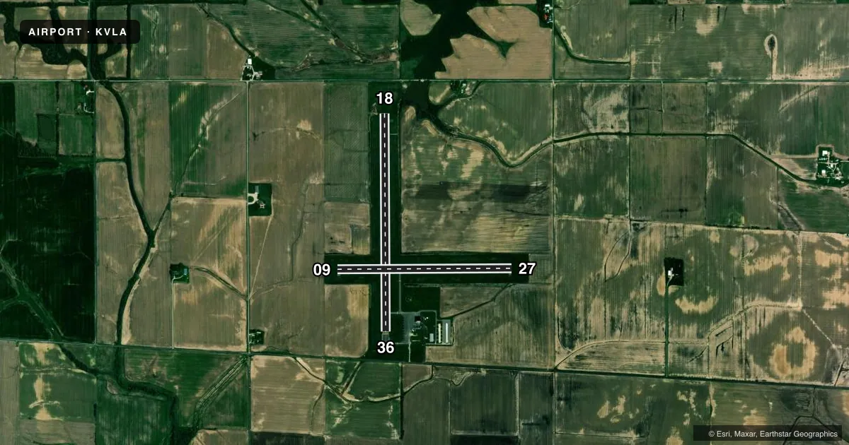
Runways & pattern
Full pagePattern entry · RWY 18
LEFT TRAFFIC| Runway | Heading (°M) | Length | Surface | Traffic |
|---|---|---|---|---|
| 18/36 | 179° / 359° | 3,751 ft | ASPH | Standard L |
| 09/27 | 89° / 269° | 3,001 ft | ASPH | Standard L |
Runway end performance
| End | TORA | TODA | ASDA | LDA | VGSI | Approach lights | Obstruction |
|---|---|---|---|---|---|---|---|
| 18 | — | — | — | — | PAPI 4-box left(3°) | — | 18', road, 575' from thr, 284' R of cntrln, slope 20 |
| 36 | — | — | — | — | — | — | 14', road, 522' from thr, 278' R of cntrln, slope 23 |
Declared distances in feet. TORA = takeoff run available, TODA = takeoff distance, ASDA = accelerate-stop, LDA = landing distance.
Airport sketch
Runways drawn to scale from FAA survey coordinates, rendered over satellite imagery. Not for navigation.
Approaches & charts
Services on the field
Fuel grades, oxygen, maintenance, ramp storage and lighting — as declared to the FAA by the airport operator.
Fuel & services
- Fuel
- 100LLA
- Oxygen (bottled)
- Not available
- Oxygen (bulk)
- Not available
- Airframe repair
- Major
- Power plant repair
- Major
- Other services
- AGRI,INSTR
Ramp & ground
- Transient storage
- Tie-down
- Hangar
- Landing fee
- No fee published
- Customs
- Not available
- Lighting schedule
- SEE RMK
- Beacon schedule
- SS-SR
- Beacon
- White / Green (civil land)(WG)
- Wind indicator
- Lighted
- Segmented circle
- Yes
Fuel & FBOs
Cheapest 100LL and Jet A on the field and nearby. Always confirm with the FBO before taxi.
Airport notes
Surface conditions, obstructions, local procedures, lighting outages and other notes published with each FAA cycle.
General notes
- FOR WX ADVY, 3 CLICKS CTAF. PHONE (618)283-9595.
- FOR CD CTC KANSAS CITY ARTCC AT 913-254-8508.
Lighting notes
- ACTVT REIL RWY 18, 27 & 36; PAPI RWY 18; MIRL RWY 09/27 - CTAF. MIRL RWY 18/36 PRESET TO LOW INTST, TO INCR INTST - CTAF.
Fuel notes
- 100LLFUEL IS SELF-SERVE WITH CREDIT CARD.
Approach & departure obstructions
- 278 FT CROPS 200 FT FM RWY END PENETRATING PART 77 SFC.
- 36APCH SLOPE 23:1 TO RELOCATED THR USING PART 77 SFC.
VFR map & nearby airports
VFR sectional. Tap any ICAO chip to open that airport.
Key facts · KVLA
Answer card- ICAO
- KVLA
- Name
- VANDALIA MUNI
- Location
- VANDALIA, ILLINOIS
- Elevation
- 537.2 ft MSL
- Traffic pattern altitude
- 1,537.2 ft MSL (1,000 AGL)
- Control tower
- Non-towered (use CTAF)
- Total runways
- 2
- Longest runway
- 18/36 · 3,751 ft
- Published ILS approaches
- 0
- Published frequencies
- 2
- Magnetic variation
- 1°
- Current flight rules
- VFR
- Current wind
- Calm / unavailable
- Favored runway now
- –
Vandalia Muni sits in Vandalia, Illinois. Field elevation is 537.2 ft MSL. It has two asphalt runways. The longest is 3,751 ft on runway 18/36. This is a non-towered field, so use CTAF 122.8 for traffic, weather advisory and runway lighting control. No ILS approaches are published here.
Pattern altitude is not published. Use the standard 1,000 ft AGL pattern for light piston traffic unless current procedures say otherwise. The airport has one on-field FBO, Vandalia Municipal Airport. It carries 100LL and Jet A Prist. 100LL is self-serve with credit card. The published remarks also note REIL lighting on runways 18, 27 and 36. Runway 18 has PAPI. Runway 09/27 has medium intensity runway lights on CTAF. Runway 18/36 medium intensity lights are preset to low intensity. Use CTAF if you need to increase intensity.
First-time pilots should pay attention to the published obstruction notes. There are 8-foot crops about 200 ft from the runway end that affect runway 27. The approach slope is also noted for runway 36 to the relocated threshold. Clearance delivery is handled through Kansas City ARTCC by phone. At this field, a current chart check matters more than assumptions. Verify the latest Chart Supplement before you go.