METAR & TAF 1H2
Current METAR
Observed 13:35Z
K1H2 271335Z AUTO 24005KT 10SM CLR 25/24 A2992 RMK AO2 T02480236
- Wind
- 240° @ 5 kt
- Visibility
- 10 SM
- Temp / Dew
- 25°C / 24°C
- Altimeter
- 29.92 inHg
- Clouds
- CLR
- Density alt
- 1,926 ft
- Ceiling
- Unlimited
- Rules
- VFR
Airport info & contacts
Manager on record, flight service, ARTCC, attendance schedule and pattern altitude — published by the FAA and refreshed every 28 days.
Location
- From city
- 3 NM S
- VFR sectional
- ST LOUIS
- ARTCC
- ZKC · KANSAS CITY
- NOTAM facility
- 1H2 (NOTAM-D)
Airport manager
- Name
- JERRY TATE
- Phone
- 217-536-5312
- Address
- 14449 E 1100TH AVE, EFFINGHAM IL 62401
Flight service · Hours
- FSS STL
- SAINT LOUIS1-800-WX-BRIEF
- Attendance
- 0800-1700
Frequencies
Tap any row to copy the frequency to your clipboard.
Runways & pattern
Full pagePattern entry · RWY 29
LEFT TRAFFIC| Runway | Heading (°M) | Length | Surface | Traffic |
|---|---|---|---|---|
| 11/29Favored | 112° / 292° | 6,002 ft | CONC | Standard L |
| 01/19 | 6° / 186° | 3,399 ft | ASPH | Standard L |
Runway end performance
| End | TORA | TODA | ASDA | LDA | VGSI | Approach lights | Obstruction |
|---|---|---|---|---|---|---|---|
| 01 | — | — | — | — | PSIL(4°) | — | — |
| 19 | — | — | — | — | PSIL(3.5°) | — | 32', tree, 840' from thr, 0' R of cntrln, slope 20 |
Declared distances in feet. TORA = takeoff run available, TODA = takeoff distance, ASDA = accelerate-stop, LDA = landing distance.
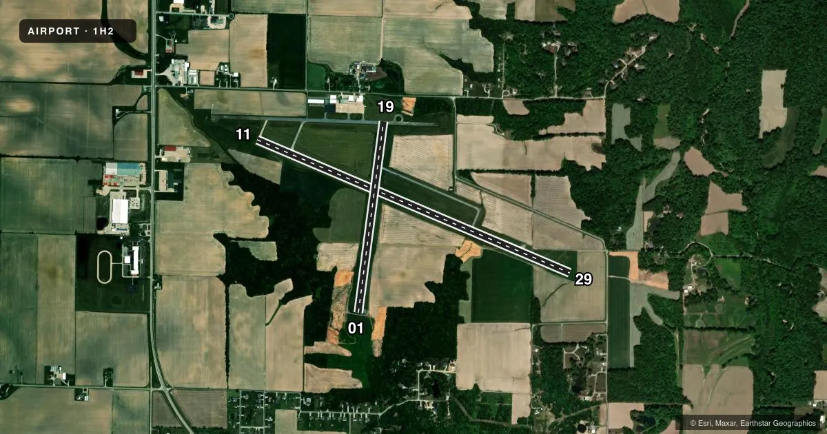
Airport sketch
Runways drawn to scale from FAA survey coordinates, rendered over satellite imagery. Not for navigation.
Approaches & charts
Services on the field
Fuel grades, oxygen, maintenance, ramp storage and lighting — as declared to the FAA by the airport operator.
Fuel & services
- Fuel
- 100LLA
- Oxygen (bottled)
- Not available
- Oxygen (bulk)
- Not available
- Airframe repair
- Major
- Power plant repair
- Major
- Other services
- INSTR
Ramp & ground
- Transient storage
- Tie-down
- Hangar
- Landing fee
- No fee published
- Customs
- Not available
- Lighting schedule
- SEE RMK
- Beacon schedule
- SS-SR
- Beacon
- White / Green (civil land)(WG)
- Wind indicator
- Lighted
- Segmented circle
- No
Fuel & FBOs
Cheapest 100LL and Jet A on the field and nearby. Always confirm with the FBO before taxi.
Airport notes
Surface conditions, obstructions, local procedures, lighting outages and other notes published with each FAA cycle.
General notes
- TREE & SILO R TRSN AREA TREE L TRSN AREA RWY 19.
- FOR CD CTC KANSAS CITY ARTCC AT 913-254-8508.
Lighting notes
- DUSK-DAWN. ACTVT REIL RWY 11 & 29; PSIL RWY 01 & 19; MIRL RWY 01/19, MIRL RWY 11/29 PRESET LOW INTST, TO INCR INTST & ACTVT - CTAF.
Approach & departure obstructions
- 01RWY 01 PVASI UNUSBL BYD 5 DEG LEFT & RIGHT OF CRS.
- 19RWY 19 PVASI UNUSBL BYD 7 DEG LEFT & RIGHT OF CRS.
VFR map & nearby airports
VFR sectional. Tap any ICAO chip to open that airport.
Key facts · 1H2
Answer card- ICAO
- 1H2
- Name
- EFFINGHAM COUNTY RGNL
- Location
- EFFINGHAM, ILLINOIS
- Elevation
- 585.3 ft MSL
- Traffic pattern altitude
- 1,585.3 ft MSL (1,000 AGL)
- Control tower
- Non-towered (use CTAF)
- Total runways
- 2
- Longest runway
- 11/29 · 6,002 ft
- Published ILS approaches
- 0
- Published frequencies
- 2
- Magnetic variation
- 1°
- Current flight rules
- VFR
- Current wind
- 240° at 5 kt
- Favored runway now
- RWY 29
Effingham County Rgnl is in Effingham, Illinois. The field elevation is 585.2 ft MSL. It has two runways. The longest is 5,103 ft on runway 11/29. This is an untowered field, so standard CTAF self-announce work applies. CTAF and UNICOM are both 122.725. No ILS approaches are published here.
The published pattern altitude is not listed, so plan on the standard 1,000 ft AGL for light piston traffic unless the current Chart Supplement says otherwise. Tate's Flying Service is on the field. It carries 100LL and Jet A. Lighting is available from dusk to dawn. Runway end identifier lights are available for 11 and 29. Runway 01 and 19 use pulsating sidelights. The runway lights are preset to low intensity. Use the CTAF to increase intensity and activate the lighting.
A few published remarks matter on arrival. The PAPI on runway 01 is only usable close to centerline. The same is true on runway 19, with a slightly wider tolerance. There are also trees and a silo near the right side of the transition area for runway 19. There is also a tree on the left side. If you need clearance delivery, contact Kansas City ARTCC before departure. For a first look, this is a straightforward Midwest airport with a long primary runway. Just brief the lighting, watch the runway 19 transition area and verify current procedures in the Chart Supplement before you go.