METAR & TAF 1H8
1H8 does not publish a METAR.
Showing the nearest reporting station: KMTO (COLES COUNTY MEML) · 16.6 NM away. Conditions at 1H8 may differ.
METAR · KMTO
Observed 14:53Z
KMTO 271453Z AUTO 24009KT 10SM CLR 29/23 A2988 RMK AO2 SLP110 60001 T02940228 56007 TSNO
- Wind
- 240° @ 9 kt
- Visibility
- 10 SM
- Temp / Dew
- 29°C / 23°C
- Altimeter
- 29.88 inHg
- Clouds
- CLR
- Density alt
- 2,542 ft
- Ceiling
- Unlimited
- Rules
- VFR
Airport info & contacts
Manager on record, flight service, ARTCC, attendance schedule and pattern altitude — published by the FAA and refreshed every 28 days.
Location
- From city
- 1 NM NW
- VFR sectional
- ST LOUIS
- Pattern altitude
- 800 ft AGL · 1,455 ft MSL
- ARTCC
- ZID · INDIANAPOLIS
- NOTAM facility
- STL (NOTAM-D)
Airport manager
- Name
- CHRIS WHITE
- Phone
- 908-247-1000
- Address
- 2624 E WASHINGTON STREET, CASEY IL 62420
Flight service · Hours
- FSS STL
- SAINT LOUIS1-800-WX-BRIEF
- Attendance
- MON-SAT · 0800-1700
Frequencies
Tap any row to copy the frequency to your clipboard.
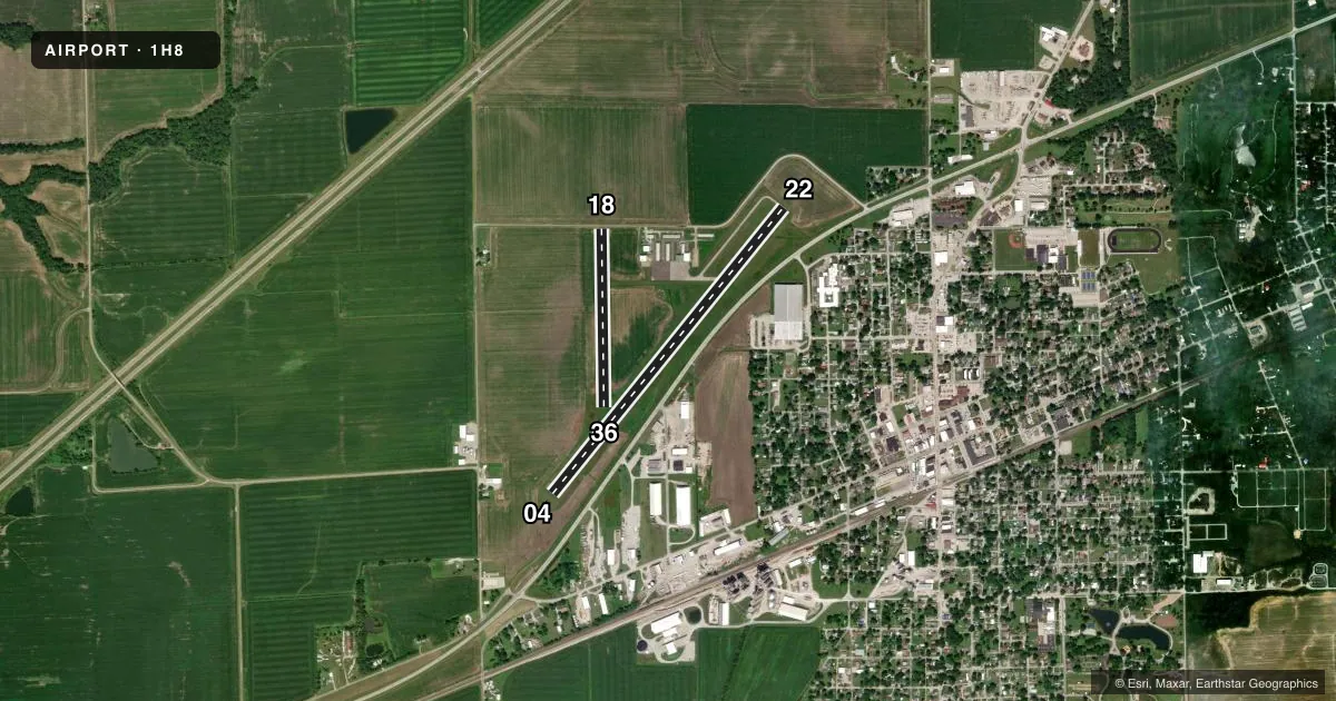
Runways & pattern
Full pagePattern entry · RWY 22
RIGHT TRAFFIC| Runway | Heading (°M) | Length | Surface | Traffic |
|---|---|---|---|---|
| 04/22Favored | 36° / 216° | 4,001 ft | ASPH | 22 R |
| 18/36 | 176° / 356° | 1,943 ft | TURF | 18 R |
Runway end performance
| End | TORA | TODA | ASDA | LDA | VGSI | Approach lights | Obstruction |
|---|---|---|---|---|---|---|---|
| 18 | — | — | — | — | — | — | 16', road, 5' from thr, 0' R of cntrln, slope 0 |
Declared distances in feet. TORA = takeoff run available, TODA = takeoff distance, ASDA = accelerate-stop, LDA = landing distance.
Airport sketch
Runways drawn to scale from FAA survey coordinates, rendered over satellite imagery. Not for navigation.
Approaches & charts
Services on the field
Fuel grades, oxygen, maintenance, ramp storage and lighting — as declared to the FAA by the airport operator.
Fuel & services
- Fuel
- 100LL
- Airframe repair
- Major
- Power plant repair
- Major
- Other services
- AGRI
Ramp & ground
- Transient storage
- Tie-down
- Hangar
- Landing fee
- No fee published
- Customs
- Not available
- Lighting schedule
- SEE RMK
- Beacon schedule
- SS-SR
- Beacon
- White / Green (civil land)(WG)
- Wind indicator
- Lighted
- Segmented circle
- Yes
Fuel & FBOs
Cheapest 100LL and Jet A on the field and nearby. Always confirm with the FBO before taxi.
Airport notes
Surface conditions, obstructions, local procedures, lighting outages and other notes published with each FAA cycle.
General notes
- FOR CD CTC HULMAN APCH AT 812-877-7581.
Lighting notes
- MIRL RY 04/22 PRESET ON LOW INTST; TO INCR INTST & ACTVT TWY LGTS - CTAF.
Approach & departure obstructions
- 04RWY 4 & 22 HAVE SEASONAL CROPS PENTG PART 77 SFC
- 18DSPLCD THR MKD WITH WHITE GRAVEL IN SHAPE OF 'L' ON RY EDGES.
- 18APCH RATIO 20:1 TO DSPLCD THR.
Other notes
- MANAGEREMAIL ADDRESS: LCPTWHITE@YAHOO.COM (ALL LOWER CASE)
- MANAGEROR 908-247-1000
VFR map & nearby airports
VFR sectional. Tap any ICAO chip to open that airport.
Key facts · 1H8
Answer card- ICAO
- 1H8
- Name
- CASEY MUNI
- Location
- CASEY, ILLINOIS
- Elevation
- 654.9 ft MSL
- Traffic pattern altitude
- 1,454.9 ft MSL (800 AGL)
- Control tower
- Non-towered (use CTAF)
- Total runways
- 2
- Longest runway
- 04/22 · 4,001 ft
- Published ILS approaches
- 0
- Published frequencies
- 4
- Magnetic variation
- 3°
- Current flight rules
- VFR
- Current wind
- 240° at 9 kt
- Favored runway now
- RWY 22
Casey Muni sits in Casey, Illinois. Field elevation is 654.9 ft MSL. The airport has two runways. The longest is 4,001 ft on runway 04/22, which is asphalt. Runway 18/36 is 1,943 ft of turf. There is no control tower. Pattern altitude is 800 ft AGL, which is 1,454.9 ft MSL.
No ILS approaches are published here. Plan with that in mind if you are arriving in lower weather. CTAF and UNICOM are both 122.8. Hulman Approach handles clearance delivery and approach or departure services on 125.45 and 263.125. For clearance delivery, the published remarks list Hulman Approach at 812-877-7581.
The runway lighting on 04/22 is medium intensity. It comes up on low intensity by default. Use CTAF to increase intensity and to activate taxiway lights. The published remarks also note seasonal crops penetrating the Part 77 surface areas near runways 04 and 22. Runway 18 has a displaced threshold marked with white gravel in an L shape on the runway edges. The approach ratio to that displaced threshold is 20 to 1. There are no on-field FBOs listed, so verify services with the airport operator or call ahead before you go.