METAR & TAF K96
K96 does not publish a METAR.
Showing the nearest reporting station: KCMI (UNIVERSITY OF ILLINOIS/WILLARD) · 15.5 NM away. Conditions at K96 may differ.
METAR · KCMI
Observed 03:53Z
KCMI 270353Z AUTO 11004KT 1 1/2SM BR CLR 23/23 A2990 RMK AO2 SLP120 T02330233
- Wind
- 110° @ 4 kt
- Visibility
- 0.5 SM
- Temp / Dew
- 23°C / 23°C
- Altimeter
- 29.90 inHg
- Clouds
- CLR
- Density alt
- 1,809 ft
- Ceiling
- Unlimited
- Rules
- LIFR
Airport info & contacts
Manager on record, flight service, ARTCC, attendance schedule and pattern altitude — published by the FAA and refreshed every 28 days.
Location
- From city
- 2 NM SW
- VFR sectional
- ST LOUIS
- Pattern altitude
- 800 ft AGL · 1,465 ft MSL
- ARTCC
- ZAU · CHICAGO
- NOTAM facility
- STL (NOTAM-D)
Airport manager
- Name
- DOMINQUE YOUAKIM
- Phone
- 217-512-1000
- Address
- 480 AIRPORT RD BLD G, MATTON IL 61953
Flight service · Hours
- FSS STL
- SAINT LOUIS1-800-WX-BRIEF
- Attendance
- MON-FRI · IRREGULAR
- SAT-SUN · ON CALL
Frequencies
Tap any row to copy the frequency to your clipboard.
Runways & pattern
Full pagePattern entry · RWY 09
LEFT TRAFFICRunway end performance
| End | TORA | TODA | ASDA | LDA | VGSI | Approach lights | Obstruction |
|---|---|---|---|---|---|---|---|
| 27 | — | — | — | — | — | — | 15', road, 15' from thr, 0' R of cntrln, slope 1 |
Declared distances in feet. TORA = takeoff run available, TODA = takeoff distance, ASDA = accelerate-stop, LDA = landing distance.
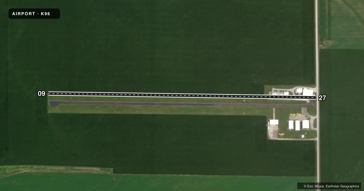
Airport sketch
Runways drawn to scale from FAA survey coordinates, rendered over satellite imagery. Not for navigation.
Approaches & charts
Services on the field
Fuel grades, oxygen, maintenance, ramp storage and lighting — as declared to the FAA by the airport operator.
Fuel & services
- Fuel
- 100LL
- Oxygen (bottled)
- Not available
- Oxygen (bulk)
- Not available
- Airframe repair
- Major
- Power plant repair
- Major
- Other services
- INSTR
Ramp & ground
- Transient storage
- Tie-down
- Hangar
- Landing fee
- No fee published
- Customs
- Not available
- Lighting schedule
- SS-SR
- Wind indicator
- Lighted
- Segmented circle
- No
Fuel & FBOs
Cheapest 100LL and Jet A on the field and nearby. Always confirm with the FBO before taxi.
Airport notes
Surface conditions, obstructions, local procedures, lighting outages and other notes published with each FAA cycle.
General notes
- SEASONAL CROPS AER RY 09 CAN PERIODICALLY BLOCK VIEW OF THLD LGTS.
- SEASONAL AGRICULTURAL OPERATIONS CONDUCTED FM ARPT.
- FOR CD CTC CHAMPAIGN APCH AT 217-355-4071, WHEN APCH CLSD CTC CHICAGO ARTCC AT 630-906-8921
Runway surface & condition
- 09/27RY LGTING ALIGNMENT DOES NOT DEFINE CENTER OF RY. RY 27 DSPLCD THLD LGTS NTSD: CONSIST OF TWO ON EACH SIDE SPACED AT 10 FT BETWEEN LGTS.
Approach & departure obstructions
- 27+15 FT BLDS 100 FT BOTH SIDES CNTRLN IN PRIM SFC.
- 27RY 27 APCH RATIO IS 16:1 FM OVER 13 FT HIGH BLDG 210 FT WEST OF RY END & 23 FT R NORTH OF CNTRLN TO MKD DSPLCD THLD. DSPLCD THLD MKD BY 12 IN WD WHT STRIPE ACROSS RY & 18 IN X 8 FT WHT CONC "ANGLES" ON BTH SDS IN GRASS.
Other notes
- 09/27SFC IS A CHIP & SEAL.
VFR map & nearby airports
VFR sectional. Tap any ICAO chip to open that airport.
Key facts · K96
Answer card- ICAO
- K96
- Name
- TUSCOLA
- Location
- TUSCOLA, ILLINOIS
- Elevation
- 665 ft MSL
- Traffic pattern altitude
- 1,465 ft MSL (800 AGL)
- Control tower
- Non-towered (use CTAF)
- Total runways
- 1
- Longest runway
- 09/27 · 2,660 ft
- Published ILS approaches
- 0
- Published frequencies
- 1
- Magnetic variation
- 0°
- Current flight rules
- LIFR
- Current wind
- 110° at 4 kt
- Favored runway now
- RWY 09
Tuscola Airport sits in Tuscola, Illinois. Field elevation is 665 ft MSL. The airport has one runway, 09/27, which is 2,660 ft long. It is a non-towered field. CTAF is 122.9. Pattern altitude is 800 ft AGL, which is 1,465 ft MSL.
There are no published ILS approaches here. The on-field FBO is Tuscola Airport. Fuel grades were not reported in the facts, so call ahead to confirm what is available before you go. Seasonal agricultural work is active at the airport. Crops near runway 09 can block the view of the threshold lights at times. Runway 27 also has a displaced threshold with nearby buildings that affect the approach path, so brief your arrival carefully.
The runway surface is chip and seal. The runway lighting setup on 09/27 does not define the center of the runway. If you need clearance delivery, contact Champaign Approach. If Approach is closed, contact Chicago ARTCC. Check the current FAA Chart Supplement for any published noise or curfew restrictions before flying into the field. This is a rural Illinois airport with a short single runway. Plan for local traffic, ag activity and a close look at the runway environment before landing.