METAR & TAF C16
C16 does not publish a METAR.
Showing the nearest reporting station: KCMI (UNIVERSITY OF ILLINOIS/WILLARD) · 7.4 NM away. Conditions at C16 may differ.
METAR · KCMI
Observed 12:53Z
KCMI 271253Z 22008KT 10SM BKN030 24/23 A2991 RMK AO2 SLP122 T02440228
- Wind
- 220° @ 8 kt
- Visibility
- 10 SM
- Temp / Dew
- 24°C / 23°C
- Altimeter
- 29.91 inHg
- Clouds
- BKN
- Density alt
- 2,004 ft
- Ceiling
- 3,000 ft AGL
- Rules
- MVFR
Airport info & contacts
Manager on record, flight service, ARTCC, attendance schedule and pattern altitude — published by the FAA and refreshed every 28 days.
Location
- From city
- 1 NM N
- VFR sectional
- CHICAGO
- ARTCC
- ZAU · CHICAGO
- NOTAM facility
- STL (NOTAM-D)
Airport manager
- Name
- TOM FRASCA
- Phone
- 217-367-8441
- Address
- 1402 E ARPT RD, URBANA IL 61801
Flight service · Hours
- FSS STL
- SAINT LOUIS1-800-WX-BRIEF
- Attendance
- DAWN-DUSK
Frequencies
Tap any row to copy the frequency to your clipboard.
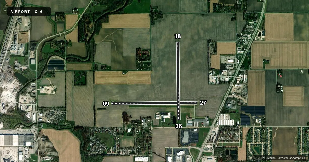
Runways & pattern
Full pagePattern entry · RWY 18
LEFT TRAFFIC| Runway | Heading (°M) | Length | Surface | Traffic |
|---|---|---|---|---|
| 09/27 | 87° / 267° | 4,001 ft | CONC | 27 R |
| 18/36Favored | 177° / 357° | 3,654 ft | TURF | Standard L |
Runway end performance
| End | TORA | TODA | ASDA | LDA | VGSI | Approach lights | Obstruction |
|---|---|---|---|---|---|---|---|
| 36 | — | — | — | — | — | — | 38', pole, 416' from thr, 101' R of cntrln, slope 10 |
Declared distances in feet. TORA = takeoff run available, TODA = takeoff distance, ASDA = accelerate-stop, LDA = landing distance.
Airport sketch
Runways drawn to scale from FAA survey coordinates, rendered over satellite imagery. Not for navigation.
Approaches & charts
Services on the field
Fuel grades, oxygen, maintenance, ramp storage and lighting — as declared to the FAA by the airport operator.
Fuel & services
- Fuel
- 100LLA
- Oxygen (bottled)
- Not available
- Oxygen (bulk)
- Not available
- Airframe repair
- Not available
- Power plant repair
- Not available
Ramp & ground
- Transient storage
- Tie-down
- Hangar
- Landing fee
- No fee published
- Customs
- Not available
- Lighting schedule
- SS-SR
- Wind indicator
- Lighted
- Segmented circle
- Yes
Fuel & FBOs
Cheapest 100LL and Jet A on the field and nearby. Always confirm with the FBO before taxi.
Airport notes
Surface conditions, obstructions, local procedures, lighting outages and other notes published with each FAA cycle.
General notes
- FOR CD CTC CHAMPAIGN APCH AT 217-355-4071, WHEN APCH CLSD CTC CHICAGO ARTCC AT 630-906-8921
Approach & departure obstructions
- 36APPCH RATIO IS 20:1 TO THE DSPLCD THLD.
Other notes
- EXISTED PRIOR TO 1959.
- MANAGEREMAIL ADDRESS: TFRASCA@FRASCA.COM (ALL LOWER CASE)
VFR map & nearby airports
VFR sectional. Tap any ICAO chip to open that airport.
Key facts · C16
Answer card- ICAO
- C16
- Name
- FRASCA FLD
- Location
- URBANA, ILLINOIS
- Elevation
- 735 ft MSL
- Traffic pattern altitude
- 1,735 ft MSL (1,000 AGL)
- Control tower
- Non-towered (use CTAF)
- Total runways
- 2
- Longest runway
- 09/27 · 4,001 ft
- Published ILS approaches
- 0
- Published frequencies
- 4
- Magnetic variation
- 2°
- Current flight rules
- MVFR
- Current wind
- 220° at 8 kt
- Favored runway now
- RWY 18
Frasca Fld sits in Urbana, Illinois at 735 ft MSL. It has two runways. The longest is 09/27 at 4,001 ft of concrete. Runway 18/36 is 3,654 ft of turf. There is no control tower. CTAF and UNICOM are both 122.8. Approach and departure service is handled by Champaign Approach on 121.35 and 285.65.
No ILS approaches are published here. Pattern altitude is not published, so use the standard 1,000 ft AGL for light piston traffic unless local procedures say otherwise. The field has one on-field FBO, Frasca Air Services. It carries 100LL and Jet A. Call them at (217) 367-8441 for current ramp or service details.
A published remark notes an obstruction-related approach ratio for runway 36 to the displaced threshold. That is worth checking before you plan a landing on that end. Clearance delivery is handled by Champaign Approach when it is open. When Champaign Approach is closed, contact Chicago ARTCC. This field has been around since before 1959. For a first visit, plan for a non-towered airport with published approach support from Champaign and review the current Chart Supplement for any changes before departure.