METAR & TAF KBMI
Current METAR
Observed 09:07Z
KBMI 270907Z AUTO 17007KT 1/2SM R20/2200V2800FT FG OVC002 25/25 A2988 RMK AO2
- Wind
- 170° @ 7 kt
- Visibility
- 0.5 SM
- Temp / Dew
- 25°C / 25°C
- Altimeter
- 29.88 inHg
- Clouds
- OVC
- Density alt
- 2,330 ft
- Ceiling
- 200 ft AGL
- Rules
- LIFR
Airport info & contacts
Manager on record, flight service, ARTCC, attendance schedule and pattern altitude — published by the FAA and refreshed every 28 days.
Location
- From city
- 3 NM E
- VFR sectional
- CHICAGO
- ARTCC
- ZKC · KANSAS CITY
- NOTAM facility
- BMI (NOTAM-D)
Airport manager
- Name
- CARL G. OLSON
- Phone
- 309-663-7383
- Address
- 3201 CIRA DRIVE, BLOOMINGTON IL 61704
Flight service · Hours
- FSS IKK
- KANKAKEE1-800-WX-BRIEF
- Attendance
- 0400L-2400L
Frequencies
Tap any row to copy the frequency to your clipboard.
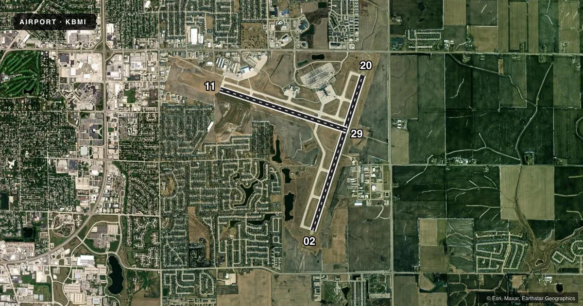
Runways & pattern
Full pagePattern entry · RWY 20
LEFT TRAFFIC| Runway | Heading (°M) | Length | Surface | Traffic |
|---|---|---|---|---|
| 02/20Favored | 15° / 195° | 8,000 ft | CONC | Standard L |
| 11/29 | 104° / 284° | 6,525 ft | ASPH-CONC | Standard L |
Runway end performance
| End | TORA | TODA | ASDA | LDA | VGSI | Approach lights | Obstruction |
|---|---|---|---|---|---|---|---|
| 02 | 8,000' | 8,000' | 8,000' | 8,000' | PAPI 4-box right(3°) | MALSR | — |
| 20 | 8,000' | 8,000' | 8,000' | 8,000' | — | ALSF2 | 40', pline, 2007' from thr, 770' R of cntrln, slope 45 |
| 11 | 6,525' | 6,525' | 6,525' | 6,525' | VASI 4-box right(3°) | — | — |
| 29 | 6,525' | 6,525' | 6,525' | 6,525' | — | MALSR | — |
Declared distances in feet. TORA = takeoff run available, TODA = takeoff distance, ASDA = accelerate-stop, LDA = landing distance.
Airport sketch
Runways drawn to scale from FAA survey coordinates, rendered over satellite imagery. Not for navigation.
Approaches & charts
ILS · 3
Services on the field
Fuel grades, oxygen, maintenance, ramp storage and lighting — as declared to the FAA by the airport operator.
Fuel & services
- Fuel
- 100LLA
- Oxygen (bottled)
- Low pressure
- Airframe repair
- Major
- Power plant repair
- Major
- Other services
- AFRT,AMB,AVNCS,CHTR,INSTR,RNTL,SALES
Ramp & ground
- Transient storage
- Tie-down
- Hangar
- Landing fee
- No fee published
- Customs
- Not available
- Lighting schedule
- SEE RMK
- Beacon schedule
- SS-SR
- Beacon
- White / Green (civil land)(WG)
- Wind indicator
- Lighted
- Segmented circle
- No
Fuel & FBOs
Cheapest 100LL and Jet A on the field and nearby. Always confirm with the FBO before taxi.
Airport notes
Surface conditions, obstructions, local procedures, lighting outages and other notes published with each FAA cycle.
General notes
- BIRDS ON & INVOF ARPT.
- SNOW REMOVAL OPS WINTER MONTHS; WHEN ATCT CLSD MNT CTAF.
- WHEN ATCT CLSD LNDG/TKOF ANNOUNCE INTENTIONS ON CTAF.
- ARPT OPS H24 - 309-834-7396.
Lighting notes
- ACTVT MALSR RWY 02 & 29; TDZ RWY 20; CNTLN 02/20; PAPI RWY 02; HIRL RWY 02/20 & 11/29 - CTAF. ALSF AVBL WHEN ATCT OPEN.
Runway surface & condition
- 02/20PCR VALUE: 700/R/D/W/T
- 11/29PCR VALUE: 700/R/C/W/T
- 11/29SE END 565 FT CONC; RMNG 5960 FT ASPH.
Approach & departure obstructions
- 20WHEN ATCT CLSD ALSF2 OPR AS SSALR.
Other notes
- 48 HR PPR FOR UNSKED ACR OPS MORE THAN 30 PAX SEATS - AMGR.
VFR map & nearby airports
VFR sectional. Tap any ICAO chip to open that airport.
Key facts · KBMI
Answer card- ICAO
- KBMI
- Name
- CENTRAL IL RGNL/BLOOMINGTON-NORMAL
- Location
- BLOOMINGTON/NORMAL, ILLINOIS
- Elevation
- 871.4 ft MSL
- Traffic pattern altitude
- 1,871.4 ft MSL (1,000 AGL)
- Control tower
- Towered · 0600-2200
- Total runways
- 2
- Longest runway
- 02/20 · 8,000 ft
- Published ILS approaches
- 3
- Published frequencies
- 9
- Magnetic variation
- 3°
- Current flight rules
- LIFR
- Current wind
- 170° at 7 kt
- Favored runway now
- RWY 20
Central IL Rgnl/Bloomington-Normal sits in Bloomington-Normal, Illinois. Field elevation is 871.4 ft MSL. The airport has two runways. The longest is runway 02/20 at 8,000 ft. Runway 11/29 is 6,525 ft. The tower is open daily from 0600 to 2200. Three ILS approaches are published. Pattern altitude is not published in the facts. Use the standard 1,000 ft AGL for light piston traffic unless the current Chart Supplement says otherwise.
Synergy Flight Center is on the field. It carries 100LL, Jet A and Jet A Prist. The airport operates 24 hours a day. Birds are reported on and near the airport. Winter snow removal is active here. Lighting is good for night work. MALSR is active on runways 02 and 29. Runway 20 has touchdown zone lighting. Centerline lighting is on 02 and 20. High intensity runway lighting is available on all four runway ends. ALSF is available when the tower is open. When the tower is closed, monitor CTAF and announce your intentions there.
This is a towered field with multiple instrument options. Check the current Chart Supplement for any noise or curfew restrictions before flying in. The airport also notes a 48-hour prior permission request for unscheduled aircraft operations with more than 30 passenger seats. For anything not covered here, call the airport operator or the FBO directly by phone.