METAR & TAF KAAA
Current METAR
Observed 13:35Z
KAAA 271335Z AUTO 21011G16KT 10SM CLR 28/25 A2990 RMK AO2 T02760252
- Wind
- 210° @ 11G16 kt
- Visibility
- 10 SM
- Temp / Dew
- 28°C / 25°C
- Altimeter
- 29.90 inHg
- Clouds
- CLR
- Density alt
- 2,322 ft
- Ceiling
- Unlimited
- Rules
- VFR
Airport info & contacts
Manager on record, flight service, ARTCC, attendance schedule and pattern altitude — published by the FAA and refreshed every 28 days.
Location
- From city
- 2 NM NE
- VFR sectional
- CHICAGO
- ARTCC
- ZKC · KANSAS CITY
- NOTAM facility
- AAA (NOTAM-D)
Airport manager
- Name
- GENE ROHLFS
- Phone
- 217-732-6400
- Address
- COUNTY COURT HOUSE, P.O. BOX 39, LINCOLN IL 62656
Flight service · Hours
- FSS STL
- SAINT LOUIS1-800-WX-BRIEF
- Attendance
- MON-SAT · IREG
Frequencies
Tap any row to copy the frequency to your clipboard.
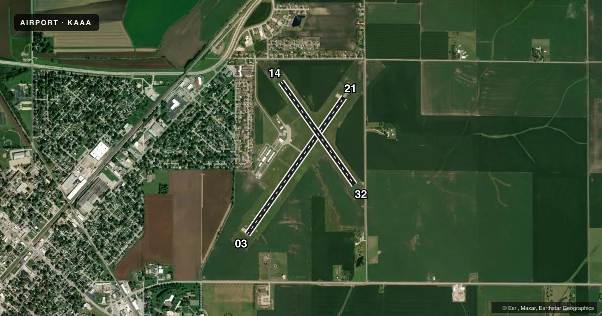
Runways & pattern
Full pagePattern entry · RWY 21
LEFT TRAFFIC| Runway | Heading (°M) | Length | Surface | Traffic |
|---|---|---|---|---|
| 03/21Favored | 35° / 215° | 4,000 ft | ASPH | Standard L |
| 14/32 | 144° / 324° | 3,021 ft | TURF | Standard L |
Runway end performance
| End | TORA | TODA | ASDA | LDA | VGSI | Approach lights | Obstruction |
|---|---|---|---|---|---|---|---|
| 03 | — | — | — | — | PAPI 4-box left(3.5°) | — | — |
| 21 | — | — | — | — | PAPI 4-box left(3°) | — | 49', tree, 1059' from thr, 200' R of cntrln, slope 17 |
| 14 | — | — | — | — | — | — | 57', trees, 797' from thr, 52' R of cntrln, slope 13 |
| 32 | — | — | — | — | — | — | 13', road, 260' from thr, 148' R of cntrln, slope 20 |
Declared distances in feet. TORA = takeoff run available, TODA = takeoff distance, ASDA = accelerate-stop, LDA = landing distance.
Airport sketch
Runways drawn to scale from FAA survey coordinates, rendered over satellite imagery. Not for navigation.
Approaches & charts
Services on the field
Fuel grades, oxygen, maintenance, ramp storage and lighting — as declared to the FAA by the airport operator.
Fuel & services
- Fuel
- 100LL
- Oxygen (bottled)
- Not available
- Oxygen (bulk)
- Not available
- Airframe repair
- Major
- Power plant repair
- Major
- Other services
- INSTR,RNTL,SALES
Ramp & ground
- Transient storage
- Tie-down
- Hangar
- Landing fee
- No fee published
- Customs
- Not available
- Lighting schedule
- SEE RMK
- Beacon schedule
- SS-SR
- Beacon
- White / Green (civil land)(WG)
- Wind indicator
- Lighted
- Segmented circle
- No
Fuel & FBOs
Cheapest 100LL and Jet A on the field and nearby. Always confirm with the FBO before taxi.
Airport notes
Surface conditions, obstructions, local procedures, lighting outages and other notes published with each FAA cycle.
General notes
- TEMPO AND LONG-TERM HNGR SPACE AVBL - DLY, WEEKLY, MONTHLY, YEARLY.
- FOR CD CTC ST LOUIS APCH 314-890-1017.
Lighting notes
- ACTVT REIL RWY 03; PAPI RWY 03 & 21; MIRL RWY 03/21 - CTAF.
Runway surface & condition
- 14/32PPR TO USE DEC-APR & AFT RAIN CALL 217-732-6400.
- 03/21225 FT STWY NE END.
Approach & departure obstructions
- 14APP SLP TO DTHR 19:1, RWY 21 APCH SLP TO RWY END IS 21:1.
- 03CHURCH STEEPLE 21:1.
Other notes
- 1FOR SVC CALL 309-838-5694 OR 217-737-3517.
- OPERATORADDITIONAL OPERATOR PHONE NUMBER: 217-737-3517.
VFR map & nearby airports
VFR sectional. Tap any ICAO chip to open that airport.
Key facts · KAAA
Answer card- ICAO
- KAAA
- Name
- LOGAN COUNTY
- Location
- LINCOLN, ILLINOIS
- Elevation
- 594.3 ft MSL
- Traffic pattern altitude
- 1,594.3 ft MSL (1,000 AGL)
- Control tower
- Non-towered (use CTAF)
- Total runways
- 2
- Longest runway
- 03/21 · 4,000 ft
- Published ILS approaches
- 0
- Published frequencies
- 4
- Magnetic variation
- 0°
- Current flight rules
- VFR
- Current wind
- 210° at 11 kt
- Favored runway now
- RWY 21
Logan County Airport sits in Lincoln, Illinois. Field elevation is 594.3 ft MSL. The airport has two runways. The longest is runway 03/21 at 4,000 ft. Runway 14/32 is turf at 3,021 ft. There is no control tower. Use CTAF 122.8 for local traffic. St. Louis Approach handles approach and departure work on 126.15 and 323.0. Clearance delivery goes through St. Louis Approach at 314-890-1017.
No ILS approaches are published here. Pattern altitude is not published, so a light piston pilot should plan on the standard 1,000 ft AGL unless the current Chart Supplement says otherwise. The on-field FBO is Logan County. It carries 100LL. Call (217) 732-6400 for current service details. Published remarks also note runway end identifier lights, PAPI and medium intensity runway lights on 03 and 21. Runway 14/32 needs prior permission from December through April and after rain. There is also a 225 ft stopway at the northeast end of 03/21. Watch the church steeple near runway 03. This is a non-towered field with mixed turf and pavement. Plan your arrival with the runway condition and local traffic in mind.