METAR & TAF KCTK
KCTK does not publish a METAR.
Showing the nearest reporting station: KPIA (GENERAL DOWNING - PEORIA INTL) · 18.3 NM away. Conditions at KCTK may differ.
METAR · KPIA
Observed 15:54Z
KPIA 271554Z 22012G22KT 9SM CLR 31/26 A2983 RMK AO2 SLP093 T03110256
- Wind
- 220° @ 12G22 kt
- Visibility
- 9 SM
- Temp / Dew
- 31°C / 26°C
- Altimeter
- 29.83 inHg
- Clouds
- CLR
- Density alt
- 2,880 ft
- Ceiling
- Unlimited
- Rules
- VFR
Airport info & contacts
Manager on record, flight service, ARTCC, attendance schedule and pattern altitude — published by the FAA and refreshed every 28 days.
Location
- From city
- 2 NM NW
- VFR sectional
- CHICAGO
- Pattern altitude
- 800 ft AGL · 1,484 ft MSL
- ARTCC
- ZKC · KANSAS CITY
- NOTAM facility
- IKK (NOTAM-D)
Airport manager
- Name
- BRENT WHEELER
- Phone
- 309-647-1345
- Address
- 250 S AVE D, CANTON IL 61520
Flight service · Hours
- FSS IKK
- KANKAKEE1-800-WX-BRIEF
- Attendance
- 0700-DUSK
Frequencies
Tap any row to copy the frequency to your clipboard.
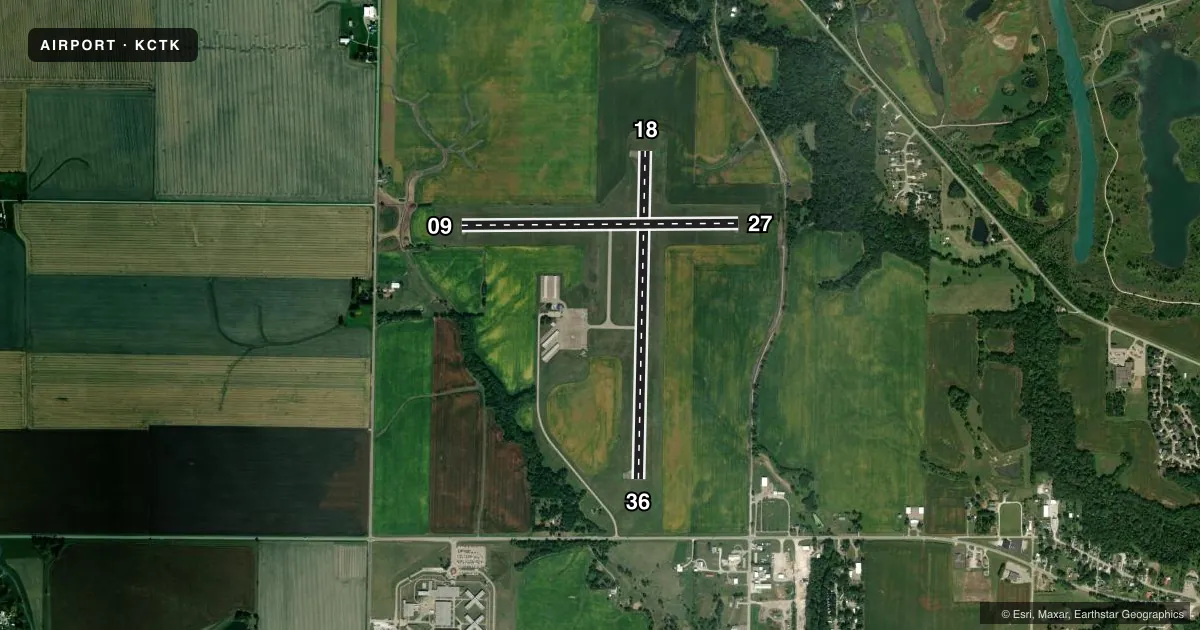
Runways & pattern
Full pagePattern entry · RWY 18
LEFT TRAFFIC| Runway | Heading (°M) | Length | Surface | Traffic |
|---|---|---|---|---|
| 18/36Favored | 179° / 359° | 3,899 ft | ASPH | Standard L |
| 09/27 | 87° / 267° | 3,294 ft | ASPH | Standard L |
Runway end performance
| End | TORA | TODA | ASDA | LDA | VGSI | Approach lights | Obstruction |
|---|---|---|---|---|---|---|---|
| 27 | — | — | — | — | — | — | 53', trees, 953' from thr, 92' R of cntrln, slope 14 |
Declared distances in feet. TORA = takeoff run available, TODA = takeoff distance, ASDA = accelerate-stop, LDA = landing distance.
Airport sketch
Runways drawn to scale from FAA survey coordinates, rendered over satellite imagery. Not for navigation.
Approaches & charts
Services on the field
Fuel grades, oxygen, maintenance, ramp storage and lighting — as declared to the FAA by the airport operator.
Fuel & services
- Fuel
- 100LL
- Oxygen (bottled)
- Not available
- Oxygen (bulk)
- Not available
- Airframe repair
- Major
- Power plant repair
- Major
- Other services
- INSTR,RNTL
Ramp & ground
- Transient storage
- Tie-down
- Landing fee
- No fee published
- Customs
- Not available
- Lighting schedule
- SEE RMK
- Wind indicator
- Lighted
- Segmented circle
- Yes
Fuel & FBOs
Cheapest 100LL and Jet A on the field and nearby. Always confirm with the FBO before taxi.
Airport notes
Surface conditions, obstructions, local procedures, lighting outages and other notes published with each FAA cycle.
General notes
- AWOS (DIGIWX) DECOMISSIONED
- FOR CD CTC ST LOUIS APCH AT 314-890-1017.
- AIRPORT BEACON NOT INSTALLED
Lighting notes
- ACTVT MIRL RYS 09/27 & 18/36 & REIL RY 36 & TWY LGTS - 7 CLICKS ON CTAF.
Fuel notes
- 100LLSELF-SERV FUELING
Other notes
- MANAGEREMAIL ADDRESS: CPD_JOHNSON@SBCGLOBAL.NET (ALL LOWER CASE)
VFR map & nearby airports
VFR sectional. Tap any ICAO chip to open that airport.
Key facts · KCTK
Answer card- ICAO
- KCTK
- Name
- INGERSOLL
- Location
- CANTON, ILLINOIS
- Elevation
- 683.9 ft MSL
- Traffic pattern altitude
- 1,483.9 ft MSL (800 AGL)
- Control tower
- Non-towered (use CTAF)
- Total runways
- 2
- Longest runway
- 18/36 · 3,899 ft
- Published ILS approaches
- 0
- Published frequencies
- 4
- Magnetic variation
- 2°
- Current flight rules
- VFR
- Current wind
- 220° at 12 kt
- Favored runway now
- RWY 18
Ingersoll Airport sits in Canton, Illinois. Field elevation is 683.9 ft MSL. It has two asphalt runways. The longest is 18/36 at 3,899 ft. The other runway is 09/27 at 3,294 ft. There is no control tower. CTAF and UNICOM are both 122.8. St Louis Approach handles the published approach and departure frequencies. No ILS approaches are published here.
Pattern altitude is 800 ft AGL, which is 1,483.9 ft MSL. That matters here because the field is non-towered. The traffic pattern is published at a lower AGL than many pilots expect. The airport beacon is not installed. Medium intensity runway lights are available on both runways. Runway end identifier lights are installed on runway 36. Taxiway lights are activated with seven clicks on CTAF. The AWOS DigiWX system is decommissioned. Get current weather before you launch.
Canton Park District is the on-field FBO. It carries 100LL. Self-service 100LL is available. For clearance delivery, contact St Louis Approach at 314-890-1017. If you are new to the field, plan for a non-towered arrival. Verify the lighting setup. Use the current Chart Supplement for any changes before you go.