METAR & TAF KGBG
Current METAR
Observed 12:55Z
KGBG 271255Z AUTO 18005KT 10SM CLR 27/27 A2986 RMK AO2 P0186 T02680268
- Wind
- 180° @ 5 kt
- Visibility
- 10 SM
- Temp / Dew
- 27°C / 27°C
- Altimeter
- 29.86 inHg
- Clouds
- CLR
- Density alt
- 2,462 ft
- Ceiling
- Unlimited
- Rules
- VFR
Airport info & contacts
Manager on record, flight service, ARTCC, attendance schedule and pattern altitude — published by the FAA and refreshed every 28 days.
Location
- From city
- 3 NM SW
- VFR sectional
- CHICAGO
- ARTCC
- ZAU · CHICAGO
- NOTAM facility
- GBG (NOTAM-D)
Airport manager
- Name
- AARON GAVIN
- Phone
- 309-345-3624
- Address
- 55 W. TOMPKINS ST, GALESBURG IL 61401
Flight service · Hours
- FSS IKK
- KANKAKEE1-800-WX-BRIEF
- Attendance
- MON-FRI · 0700-1900
Frequencies
Tap any row to copy the frequency to your clipboard.
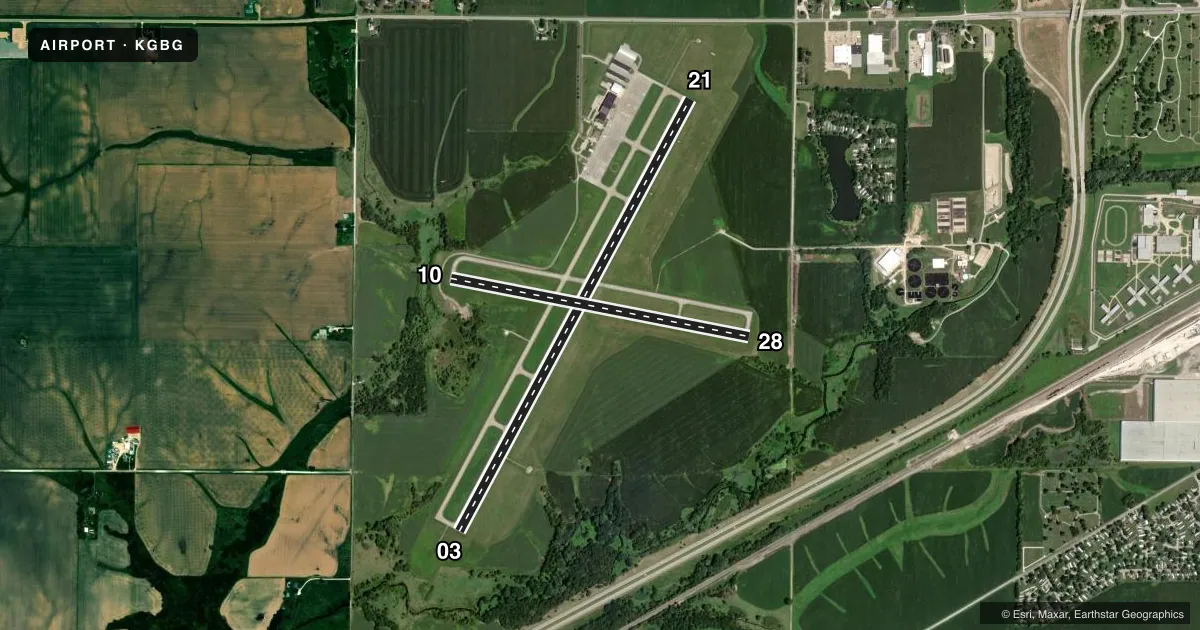
Runways & pattern
Full pagePattern entry · RWY 21
LEFT TRAFFIC| Runway | Heading (°M) | Length | Surface | Traffic |
|---|---|---|---|---|
| 03/21Favored | 26° / 206° | 5,792 ft | ASPH | Standard L |
| 10/28 | 99° / 279° | 3,600 ft | ASPH | Standard L |
Runway end performance
| End | TORA | TODA | ASDA | LDA | VGSI | Approach lights | Obstruction |
|---|---|---|---|---|---|---|---|
| 03 | — | — | — | — | — | MALSR | 18', tree, 1007' from thr, 182' R of cntrln, slope 44 |
| 21 | — | — | — | — | PAPI 4-box left(3°) | — | 57', tree, 1731' from thr, 623' R of cntrln, slope 26 |
| 28 | — | — | — | — | — | — | 2', tree, 207' from thr, 0' R of cntrln, slope 3 |
Declared distances in feet. TORA = takeoff run available, TODA = takeoff distance, ASDA = accelerate-stop, LDA = landing distance.
Airport sketch
Runways drawn to scale from FAA survey coordinates, rendered over satellite imagery. Not for navigation.
Approaches & charts
ILS · 1
Services on the field
Fuel grades, oxygen, maintenance, ramp storage and lighting — as declared to the FAA by the airport operator.
Fuel & services
- Fuel
- 100LLA
- Oxygen (bulk)
- Low pressure
- Airframe repair
- Major
- Power plant repair
- Major
- Other services
- AFRT,AMB,AVNCS,CHTR,INSTR,SALES
Ramp & ground
- Transient storage
- Hangar
- Landing fee
- No fee published
- Customs
- Not available
- Lighting schedule
- SEE RMK
- Beacon schedule
- SS-SR
- Beacon
- White / Green (civil land)(WG)
- Wind indicator
- Lighted
- Segmented circle
- Yes
Fuel & FBOs
Cheapest 100LL and Jet A on the field and nearby. Always confirm with the FBO before taxi.
Airport notes
Surface conditions, obstructions, local procedures, lighting outages and other notes published with each FAA cycle.
Lighting notes
- ACTVT MALSR RWY 03; REIL RWY 21; PAPI RWY 21; HIRL RWY 03/21; MIRL RWY 10/28 - CTAF. SS-SR HIRL RWY 03/21; MIRL RWY 10/28 PRESET LOW INTST; INCR INTST - CTAF.
Fuel notes
- 100LLSELF SVC H24.
VFR map & nearby airports
VFR sectional. Tap any ICAO chip to open that airport.
Key facts · KGBG
Answer card- ICAO
- KGBG
- Name
- HARREL W TIMMONS GALESBURG RGNL
- Location
- GALESBURG, ILLINOIS
- Elevation
- 764.3 ft MSL
- Traffic pattern altitude
- 1,764.3 ft MSL (1,000 AGL)
- Control tower
- Non-towered (use CTAF)
- Total runways
- 2
- Longest runway
- 03/21 · 5,792 ft
- Published ILS approaches
- 1
- Published frequencies
- 5
- Magnetic variation
- 2°
- Current flight rules
- VFR
- Current wind
- 180° at 5 kt
- Favored runway now
- RWY 21
Harrel W Timmons Galesburg Rgnl sits in Galesburg, Illinois at 764.3 ft MSL. It is an uncontrolled field with no control tower. The airport has two asphalt runways. The longest is 03/21 at 5,792 ft. Runway 10/28 is 3,600 ft. One ILS approach is published for runway 03. Pattern altitude is not published, so use the standard 1,000 ft AGL for light piston traffic unless the current FAA Chart Supplement says otherwise.
Jet Air, Inc. is on the field. It carries 100LL and Jet A. Self-serve 100LL is available 24 hours. The lighting setup matters here. Runway 03 has medium intensity approach lights with runway alignment indicator lights. Runway 21 has runway end identifier lights and precision approach path indicators. Runways 03 and 21 have high intensity runway lights. Runways 10 and 28 have medium intensity runway lights that are controlled by CTAF. From sunset to sunrise, the lights are preset to low intensity. Use CTAF if you need to raise them.
For a first-time arrival, the main things to plan for are the non-towered pattern, the published ILS to 03 and the lighting system if you are arriving after dark. Check the current FAA Chart Supplement for any noise or local operating notes before you go.