METAR & TAF C66
C66 does not publish a METAR.
Showing the nearest reporting station: KGBG (HARREL W TIMMONS GALESBURG RGNL) · 9.1 NM away. Conditions at C66 may differ.
METAR · KGBG
Observed 10:15Z
KGBG 271015Z AUTO 00000KT 10SM CLR 25/25 A2985 RMK AO2 P0068 T02540254
- Wind
- 000° @ 0 kt
- Visibility
- 10 SM
- Temp / Dew
- 25°C / 25°C
- Altimeter
- 29.85 inHg
- Clouds
- CLR
- Density alt
- 2,221 ft
- Ceiling
- Unlimited
- Rules
- VFR
Airport info & contacts
Manager on record, flight service, ARTCC, attendance schedule and pattern altitude — published by the FAA and refreshed every 28 days.
Location
- From city
- 2 NM N
- VFR sectional
- CHICAGO
- ARTCC
- ZAU · CHICAGO
- NOTAM facility
- IKK (NOTAM-D)
Airport manager
- Name
- ANNETTE ST. LEDGER
- Phone
- 309-734-2141
- Address
- 100 E. BROADWAY, MONMOUTH IL 61462-1764
Flight service · Hours
- FSS IKK
- KANKAKEE1-800-WX-BRIEF
- Attendance
- TUE-SUN · 0800-1630
Frequencies
Tap any row to copy the frequency to your clipboard.
Runways & pattern
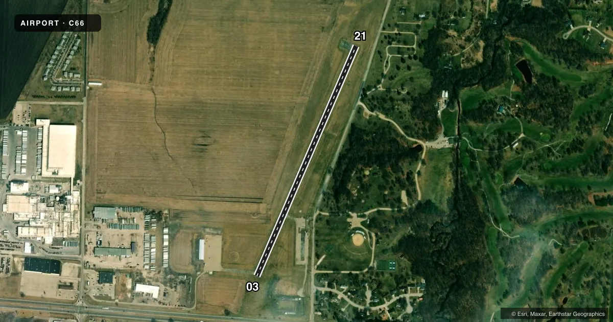
Full pagePattern entry · RWY 03
LEFT TRAFFICRunway end performance
| End | TORA | TODA | ASDA | LDA | VGSI | Approach lights | Obstruction |
|---|---|---|---|---|---|---|---|
| 03 | — | — | — | — | PAPI 2-box left(3.5°) | — | 34', tree, 681' from thr, 147' R of cntrln, slope 14 |
| 21 | — | — | — | — | PAPI 2-box left(3°) | — | 52', tree, 789' from thr, 180' R of cntrln, slope 11 |
Declared distances in feet. TORA = takeoff run available, TODA = takeoff distance, ASDA = accelerate-stop, LDA = landing distance.
Airport sketch
Runways drawn to scale from FAA survey coordinates, rendered over satellite imagery. Not for navigation.
Approaches & charts
Services on the field
Fuel grades, oxygen, maintenance, ramp storage and lighting — as declared to the FAA by the airport operator.
Fuel & services
- Fuel
- 100LLMOGAS
- Oxygen (bottled)
- Not available
- Oxygen (bulk)
- Not available
- Airframe repair
- Not available
- Power plant repair
- Not available
Ramp & ground
- Transient storage
- Tie-down
- Hangar
- Landing fee
- No fee published
- Customs
- Not available
- Lighting schedule
- SEE RMK
- Beacon schedule
- SS-SR
- Beacon
- White / Green (civil land)(WG)
- Wind indicator
- Lighted
- Segmented circle
- Yes
Fuel & FBOs
Cheapest 100LL and Jet A on the field and nearby. Always confirm with the FBO before taxi.
Airport notes
Surface conditions, obstructions, local procedures, lighting outages and other notes published with each FAA cycle.
General notes
- FOR CD CTC CHICAGO ARTCC AT 630-906-8921.
Lighting notes
- ACTVT PAPI RWY 03 & 21; MIRL RWY 03/21 PRESET LOW INTST, TO INCR INTST & ACTVT - CTAF.
Fuel notes
- 100LL24 HR SELF SERVE FUEL
Approach & departure obstructions
- 03SEASONAL CROPS IN PART 77 SFC; 200 FT FROM RWY END 61 FT L.
Other notes
- THIS AIRPORT HAS BEEN SURVEYED BY THE NATIONAL GEODETIC SURVEY.
- MANAGEREMAIL ADDRESS: ANNETTE.STLEDGER@CITYOFMONMOUTHIL.GOV
VFR map & nearby airports
VFR sectional. Tap any ICAO chip to open that airport.
Key facts · C66
Answer card- ICAO
- C66
- Name
- MONMOUTH MUNI
- Location
- MONMOUTH, ILLINOIS
- Elevation
- 753 ft MSL
- Traffic pattern altitude
- 1,753 ft MSL (1,000 AGL)
- Control tower
- Non-towered (use CTAF)
- Total runways
- 1
- Longest runway
- 03/21 · 2,899 ft
- Published ILS approaches
- 0
- Published frequencies
- 5
- Magnetic variation
- 3°
- Current flight rules
- VFR
- Current wind
- 000° at 0 kt
- Favored runway now
- –
Monmouth Muni is in Monmouth, Illinois. The field elevation is 753 ft MSL. It has one runway. Runway 03/21 is 2,899 ft long with an asphalt surface. There is no control tower. No ILS approaches are published.
The pattern altitude is not published, so plan on the standard 1,000 ft AGL for light piston traffic unless the current Chart Supplement says otherwise. That puts the pattern at 1,753 ft MSL based on the field elevation. PAPI is available on both runway ends. The runway lights on 03/21 start at low intensity. Use CTAF to increase intensity and activate them. Seasonal crops penetrate the Part 77 surface near the runway. There is also an obstruction noted 200 ft from the runway end, 61 ft left.
Monmouth Municipal Airport is the on-field FBO. It carries 100LL and MOGAS. 24-hour self-serve 100LL is available. For clearance delivery, contact Chicago ARTCC. If you are planning a night arrival or a first visit, verify the current Chart Supplement and brief the lighting setup before you go.