METAR & TAF C00
C00 does not publish a METAR.
Showing the nearest reporting station: KMLI (QUAD CITIES INTL) · 15.8 NM away. Conditions at C00 may differ.
METAR · KMLI
Observed 21:52Z
KMLI 262152Z 23006KT 10SM CLR 32/28 A2984 RMK AO2 SLP098 T03220278
- Wind
- 230° @ 6 kt
- Visibility
- 10 SM
- Temp / Dew
- 32°C / 28°C
- Altimeter
- 29.84 inHg
- Clouds
- CLR
- Density alt
- 3,057 ft
- Ceiling
- Unlimited
- Rules
- VFR
Airport info & contacts
Manager on record, flight service, ARTCC, attendance schedule and pattern altitude — published by the FAA and refreshed every 28 days.
Location
- From city
- 3 NM NE
- VFR sectional
- CHICAGO
- ARTCC
- ZAU · CHICAGO
- NOTAM facility
- IKK (NOTAM-D)
Airport manager
- Name
- JEFF ELMORE
- Phone
- 901-537-8537
- Address
- 1276 HWY 94, ALEDO IL 61231
Flight service · Hours
- FSS IKK
- KANKAKEE1-800-WX-BRIEF
- Attendance
- Unattended
Frequencies
Tap any row to copy the frequency to your clipboard.
Runways & pattern
Full pagePattern entry · RWY 17
LEFT TRAFFICRunway end performance
| End | TORA | TODA | ASDA | LDA | VGSI | Approach lights | Obstruction |
|---|---|---|---|---|---|---|---|
| 17 | — | — | — | — | — | — | 51', tree, 363' from thr, 58' R of cntrln, slope 3 |
Declared distances in feet. TORA = takeoff run available, TODA = takeoff distance, ASDA = accelerate-stop, LDA = landing distance.
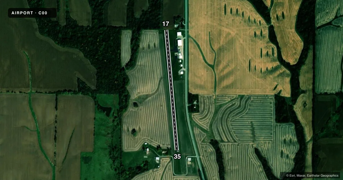
Airport sketch
Runways drawn to scale from FAA survey coordinates, rendered over satellite imagery. Not for navigation.
Approaches & charts
Services on the field
Fuel grades, oxygen, maintenance, ramp storage and lighting — as declared to the FAA by the airport operator.
Fuel & services
- Fuel
- Not available
- Oxygen (bottled)
- Not available
- Oxygen (bulk)
- Not available
Ramp & ground
- Transient storage
- Tie-down
- Hangar
- Landing fee
- No fee published
- Customs
- Not available
- Lighting schedule
- SS-SR
- Wind indicator
- Yes
- Segmented circle
- No
Fuel & FBOs
Cheapest 100LL and Jet A on the field and nearby. Always confirm with the FBO before taxi.
Airport notes
Surface conditions, obstructions, local procedures, lighting outages and other notes published with each FAA cycle.
General notes
- FOR CD CTC CHICAGO ARTCC AT 630-906-8921.
Approach & departure obstructions
- 1731 FT TREE 100 FT FROM EOR 17 AT 98 FT R.
- 35FARM DRIVEWAY +15 ABOVE RWY 70 FT FROM EOR 35 AT 110 FT L
Other notes
- MANAGEREMAIL ADDRESS: GARRETT@LINDELLAERIALAG.COM (ALL LOWER CASE)
- OWNERGARRETT LINDELL OF ABL, LLC
VFR map & nearby airports
VFR sectional. Tap any ICAO chip to open that airport.
Key facts · C00
Answer card- ICAO
- C00
- Name
- MERCER COUNTY
- Location
- ALEDO, ILLINOIS
- Elevation
- 740 ft MSL
- Traffic pattern altitude
- 1,740 ft MSL (1,000 AGL)
- Control tower
- Non-towered (use CTAF)
- Total runways
- 1
- Longest runway
- 17/35 · 2,480 ft
- Published ILS approaches
- 0
- Published frequencies
- 1
- Magnetic variation
- 2°
- Current flight rules
- VFR
- Current wind
- 230° at 6 kt
- Favored runway now
- RWY 17
Mercer County Airport sits in Aledo, Illinois. The field elevation is 740 ft MSL. It has one runway, 17/35, which is 2,480 ft long and asphalt. The airport is not towered. CTAF is 122.9. No ILS approaches are published here.
Pattern altitude is not published. Use the standard 1,000 ft AGL pattern for light piston traffic unless the current Chart Supplement says otherwise. The published runway headings are magnetic. Runway 17 is 174.985° magnetic. Runway 35 is 354.985° magnetic.
There are no on-field FBOs listed in the facts. Contact the airport operator directly before arrival, or call the field on CTAF for current service availability. Published remarks note a farm driveway near the departure end of runway 35. There is also a 31-foot tree near the departure end of runway 17. Those obstructions matter on short final and during takeoff planning. For clearance delivery, contact Chicago ARTCC at 630-906-8921. If you need current noise, curfew, or local operating guidance, check the current FAA Chart Supplement before you go.