METAR & TAF KMUT
Current METAR
Observed 18:35Z
KMUT 261835Z AUTO 23004KT 10SM CLR 30/27 A2989 RMK A01
- Wind
- 230° @ 4 kt
- Visibility
- 10 SM
- Temp / Dew
- 30°C / 27°C
- Altimeter
- 29.89 inHg
- Clouds
- CLR
- Density alt
- 2,516 ft
- Ceiling
- Unlimited
- Rules
- VFR
Airport info & contacts
Manager on record, flight service, ARTCC, attendance schedule and pattern altitude — published by the FAA and refreshed every 28 days.
Location
- From city
- 5 NM SW
- VFR sectional
- CHICAGO
- ARTCC
- ZAU · CHICAGO
- NOTAM facility
- MUT (NOTAM-D)
Airport manager
- Name
- MIKE WOERLY
- Phone
- 563-263-8672
- Address
- 5701 SOUTH HIGHWAY 61, MUSCATINE IA 52761
Flight service · Hours
- FSS FOD
- FORT DODGE1-800-WX-BRIEF
- Attendance
- MON - FRI · 0700-1800
- SAT - SUN · 0800-1600
Frequencies
Tap any row to copy the frequency to your clipboard.
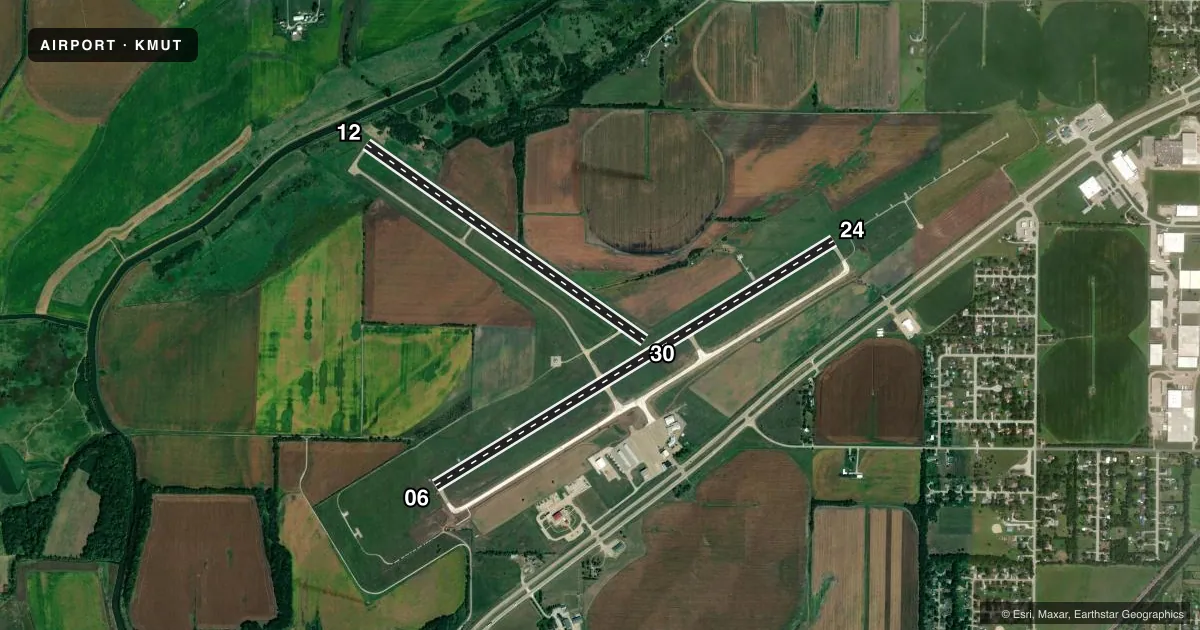
Runways & pattern
Full pagePattern entry · RWY 24
LEFT TRAFFIC| Runway | Heading (°M) | Length | Surface | Traffic |
|---|---|---|---|---|
| 06/24Favored | 57° / 238° | 5,500 ft | CONC | Standard L |
| 12/30 | 124° / 304° | 4,000 ft | CONC | Standard L |
Runway end performance
| End | TORA | TODA | ASDA | LDA | VGSI | Approach lights | Obstruction |
|---|---|---|---|---|---|---|---|
| 06 | — | — | — | — | VASI 4-box left(3°) | — | 77', tree, 2097' from thr, 102' R of cntrln, slope 24 |
| 24 | — | — | — | — | PAPI 4-box right(3°) | MALSR | — |
| 12 | — | — | — | — | PAPI 2-box left(3.25°) | — | 8', tree, 353' from thr, 13' R of cntrln, slope 19 |
| 30 | — | — | — | — | PAPI 2-box left(3°) | — | — |
Declared distances in feet. TORA = takeoff run available, TODA = takeoff distance, ASDA = accelerate-stop, LDA = landing distance.
Airport sketch
Runways drawn to scale from FAA survey coordinates, rendered over satellite imagery. Not for navigation.
Approaches & charts
ILS · 1
Services on the field
Fuel grades, oxygen, maintenance, ramp storage and lighting — as declared to the FAA by the airport operator.
Fuel & services
- Fuel
- 100LLA
- Oxygen (bottled)
- Not available
- Oxygen (bulk)
- Not available
- Airframe repair
- Minor
- Power plant repair
- Minor
- Other services
- CHTR,INSTR,RNTL,SALES
Ramp & ground
- Transient storage
- Tie-down
- Hangar
- Landing fee
- No fee published
- Customs
- Not available
- Lighting schedule
- SEE RMK
- Beacon schedule
- SS-SR
- Beacon
- White / Green (civil land)(WG)
- Wind indicator
- Lighted
- Segmented circle
- No
Fuel & FBOs
Cheapest 100LL and Jet A on the field and nearby. Always confirm with the FBO before taxi.
Airport notes
Surface conditions, obstructions, local procedures, lighting outages and other notes published with each FAA cycle.
General notes
- GLIDER OPN ON ARPT.
- FOR CD CTC CHICAGO ARTCC AT 630-906-8921.
Lighting notes
- MIRL RYS 06/24 & 12/30 PRESET ON LOW INTST; TO INCR INTST & ACTVT VASI RY 06; MALSR RY 24; PAPI RYS 24, 12 & 30; REIL RYS 06; 12 & 30 - CTAF.
Other notes
- THIS AIRPORT HAS BEEN SURVEYED BY THE NATIONAL GEODETIC SURVEY.
- EXISTED PRIOR TO 1959.
- 1FOR ATTENDANT AFT HRS CALL (563) 263-8672; ARPT UNATNDD CITY HOLIDAYS.
VFR map & nearby airports
VFR sectional. Tap any ICAO chip to open that airport.
Key facts · KMUT
Answer card- ICAO
- KMUT
- Name
- MUSCATINE MUNI
- Location
- MUSCATINE, IOWA
- Elevation
- 547.2 ft MSL
- Traffic pattern altitude
- 1,547.2 ft MSL (1,000 AGL)
- Control tower
- Non-towered (use CTAF)
- Total runways
- 2
- Longest runway
- 06/24 · 5,500 ft
- Published ILS approaches
- 1
- Published frequencies
- 5
- Magnetic variation
- 1°
- Current flight rules
- VFR
- Current wind
- 230° at 4 kt
- Favored runway now
- RWY 24
Muscatine Muni sits in Muscatine, Iowa. Field elevation is 547.2 ft MSL. The airport has two concrete runways. The longest is 5,500 ft on 06/24. Runway 12/30 is 4,000 ft. There is no control tower. Plan on CTAF 122.7 for local traffic and UNICOM on the same frequency.
One ILS is published here for runway 24. That makes 24 the main instrument option to study before arrival. Pattern altitude is not published, so use the standard 1,000 ft AGL unless the current Chart Supplement says otherwise. The published lighting setup is worth a look before a night arrival. Runway lights on both runways are preset to low intensity. The approach lighting and PAPI setup is tied to runway 24. REILs are on 06, 12 and 30. They are controlled from CTAF.
Jet Air, Inc. is on the field. It carries 100LL and Jet A. Call (563) 263-8672 for after-hours attendant service. The airport is unattended on city holidays. Glider operations also take place here, so keep your scan sharp in the pattern and on final. For clearance delivery, contact Chicago ARTCC at 630-906-8921. If you are planning an IFR arrival or a night stop, verify the current Chart Supplement before you go.