METAR & TAF KAWG
Current METAR
Observed 13:35Z
KAWG 271335Z AUTO 21009KT A2978 RMK AO2
- Wind
- 210° @ 9 kt
- Visibility
- —
- Temp / Dew
- —
- Altimeter
- 29.78 inHg
- Clouds
- Clear
- Density alt
- —
- Ceiling
- Unlimited
- Rules
- VFR
Airport info & contacts
Manager on record, flight service, ARTCC, attendance schedule and pattern altitude — published by the FAA and refreshed every 28 days.
Location
- From city
- 2 NM SE
- VFR sectional
- CHICAGO
- ARTCC
- ZAU · CHICAGO
- NOTAM facility
- AWG (NOTAM-D)
Airport manager
- Name
- KURT KUCERA
- Phone
- 319-461-0359
- Address
- 1625 SOUTH AIRPORT RD, WASHINGTON IA 52353
Flight service · Hours
- FSS FOD
- FORT DODGE1-800-WX-BRIEF
- Attendance
- MON-THURS · 0700-1500
Frequencies
Tap any row to copy the frequency to your clipboard.
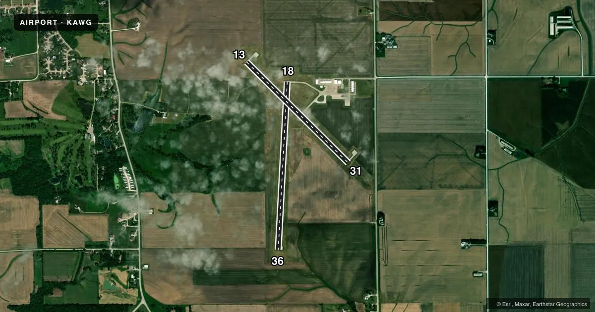
Runways & pattern
Full pagePattern entry · RWY 18
LEFT TRAFFIC| Runway | Heading (°M) | Length | Surface | Traffic |
|---|---|---|---|---|
| 18/36Favored | 182° / 2° | 4,000 ft | CONC | Standard L |
| 13/31 | 134° / 314° | 3,401 ft | CONC | Standard L |
Runway end performance
| End | TORA | TODA | ASDA | LDA | VGSI | Approach lights | Obstruction |
|---|---|---|---|---|---|---|---|
| 18 | — | — | — | — | PAPI 2-box right(4°) | — | — |
| 36 | — | — | — | — | PAPI 2-box left(3°) | — | — |
| 13 | — | — | — | — | PAPI 2-box left(3°) | — | — |
| 31 | — | — | — | — | PAPI 2-box left(3°) | — | 15', road, 700' from thr, 250' R of cntrln, slope 33 |
Declared distances in feet. TORA = takeoff run available, TODA = takeoff distance, ASDA = accelerate-stop, LDA = landing distance.
Airport sketch
Runways drawn to scale from FAA survey coordinates, rendered over satellite imagery. Not for navigation.
Approaches & charts
Services on the field
Fuel grades, oxygen, maintenance, ramp storage and lighting — as declared to the FAA by the airport operator.
Fuel & services
- Fuel
- 100LLA
- Oxygen (bottled)
- Not available
- Oxygen (bulk)
- High pressure
- Airframe repair
- Major
- Power plant repair
- Major
- Other services
- SALES
Ramp & ground
- Transient storage
- Tie-down
- Hangar
- Landing fee
- No fee published
- Customs
- Not available
- Lighting schedule
- SEE RMK
- Beacon schedule
- SS-SR
- Beacon
- White / Green (civil land)(WG)
- Wind indicator
- Lighted
- Segmented circle
- No
Fuel & FBOs
Cheapest 100LL and Jet A on the field and nearby. Always confirm with the FBO before taxi.
Airport notes
Surface conditions, obstructions, local procedures, lighting outages and other notes published with each FAA cycle.
General notes
- RY 36 IS CALM WIND RY.
- FOR CD CTC CHICAGO ARTCC AT 630-906-8921.
Lighting notes
- ACTVT MIRL RY 13/31, MIRL RY 18/36; PAPI RYS 18/36 AND 13/31 AND REIL RYS 18/36 AND 13/31- CTAF.
Fuel notes
- 100LLFUEL AVBL 24 HRS BY CREDIT CARD
Other notes
- CONDL: PROVIDED A CLEAR APPROACH TO EACH RWY IS MAINTAINED FOR A MINIMUM 20:1 GLIDE SLOPE AND THE TRANSITIONAL SURFACE IS MAINTAINED FOR A 7:1 SLOPE.
- 1AVAILABLE 24/7 AT 319-653-7002
VFR map & nearby airports
VFR sectional. Tap any ICAO chip to open that airport.
Key facts · KAWG
Answer card- ICAO
- KAWG
- Name
- WASHINGTON MUNI
- Location
- WASHINGTON, IOWA
- Elevation
- 754.4 ft MSL
- Traffic pattern altitude
- 1,754.4 ft MSL (1,000 AGL)
- Control tower
- Non-towered (use CTAF)
- Total runways
- 2
- Longest runway
- 18/36 · 4,000 ft
- Published ILS approaches
- 0
- Published frequencies
- 2
- Magnetic variation
- 1°
- Current flight rules
- VFR
- Current wind
- 210° at 9 kt
- Favored runway now
- RWY 18
Washington Muni sits in Washington, Iowa. Field elevation is 754.4 ft MSL. The airport has two concrete runways. The longest is Runway 18/36 at 4,000 ft. It is non-towered. CTAF and UNICOM are both 122.7. No ILS approaches are published here.
Pattern altitude is not published. Use 1,000 ft AGL for light piston operations unless the current Chart Supplement says otherwise. The published calm wind runway is Runway 36. That matters on a light day because it gives you a simple default for the pattern.
Washington Airport is on the field. It carries AVGAS 100LL and Jet A. Fuel is available 24 hours by credit card. Airport services are also listed as available 24 hours a day. Runway lights are medium intensity on both runways. PAPI and REIL are installed on Runways 18/36 and 13/31.
For a first-time arrival, pay attention to the published clear approach surfaces and the 7 to 1 transitional surface note. The field is in a small-town setting with no tower, so self-announce early and keep a sharp scan in the pattern. If you need clearance delivery, contact Chicago ARTCC at 630-906-8921 before departure.