METAR & TAF KIOW
Current METAR
Observed 15:52Z
KIOW 271552Z AUTO 21008KT 10SM CLR 32/26 A2978 RMK AO2 LTG DSNT S SLP076 T03170261
- Wind
- 210° @ 8 kt
- Visibility
- 10 SM
- Temp / Dew
- 32°C / 26°C
- Altimeter
- 29.78 inHg
- Clouds
- CLR
- Density alt
- 3,061 ft
- Ceiling
- Unlimited
- Rules
- VFR
Airport info & contacts
Manager on record, flight service, ARTCC, attendance schedule and pattern altitude — published by the FAA and refreshed every 28 days.
Location
- From city
- 2 NM SW
- VFR sectional
- CHICAGO
- ARTCC
- ZAU · CHICAGO
- NOTAM facility
- IOW (NOTAM-D)
Airport manager
- Name
- MICHAEL THARP
- Phone
- 319-356-5045
- Address
- 1801 S. RIVERSIDE, IOWA CITY IA 52246
Flight service · Hours
- FSS FOD
- FORT DODGE1-800-WX-BRIEF
- Attendance
- 0630-2030
Frequencies
Tap any row to copy the frequency to your clipboard.
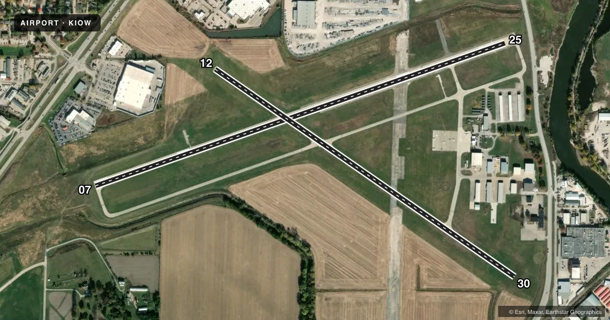
Runways & pattern
Full pagePattern entry · RWY 25
LEFT TRAFFIC| Runway | Heading (°M) | Length | Surface | Traffic |
|---|---|---|---|---|
| 07/25Favored | 70° / 250° | 5,002 ft | CONC | 07 R |
| 12/30 | 124° / 304° | 4,200 ft | CONC | 12 R |
Runway end performance
| End | TORA | TODA | ASDA | LDA | VGSI | Approach lights | Obstruction |
|---|---|---|---|---|---|---|---|
| 07 | 5,002' | 5,152' | 5,002' | 5,002' | PAPI 4-box left(3.5°) | — | 88', pole, 2079' from thr, 263' R of cntrln, slope 21 |
| 25 | 5,002' | 5,002' | 5,002' | 4,872' | PAPI 4-box left(3°) | — | — |
| 12 | 4,200' | 4,200' | 4,200' | 3,700' | — | — | 85', tree, 1454' from thr, 25' R of cntrln, slope 14 |
| 30 | 4,200' | 4,200' | 4,200' | 3,900' | PAPI 2-box left(3.5°) | — | 84', tree, 1327' from thr, 409' R of cntrln, slope 13 |
Declared distances in feet. TORA = takeoff run available, TODA = takeoff distance, ASDA = accelerate-stop, LDA = landing distance.
Airport sketch
Runways drawn to scale from FAA survey coordinates, rendered over satellite imagery. Not for navigation.
Approaches & charts
Services on the field
Fuel grades, oxygen, maintenance, ramp storage and lighting — as declared to the FAA by the airport operator.
Fuel & services
- Fuel
- 100LLA
- Oxygen (bottled)
- Not available
- Oxygen (bulk)
- Not available
- Airframe repair
- Major
- Power plant repair
- Major
- Other services
- AMB,CHTR,INSTR,RNTL,SALES
Ramp & ground
- Transient storage
- Tie-down
- Hangar
- Landing fee
- No fee published
- Customs
- Not available
- Lighting schedule
- SEE RMK
- Beacon schedule
- SS-SR
- Beacon
- White / Green (civil land)(WG)
- Wind indicator
- Lighted
- Segmented circle
- Yes
Fuel & FBOs
Cheapest 100LL and Jet A on the field and nearby. Always confirm with the FBO before taxi.
Airport notes
Surface conditions, obstructions, local procedures, lighting outages and other notes published with each FAA cycle.
General notes
- NOISE ABATEMENT PROCEDURES IN EFFECT, CTC ARPT MGR 319-356-5045.
- WATERFOWL & DEER ON & INVOF ARPT.
- HEL ACTIVITY 3/4 MILE N OF ARPT INVOF UNIVERSITY OF IOWA HOSPITAL.
- NUMEROUS UNLGTD CRANES 200 FT AGL 2 NM RDS OF ARPT.
- GLIDER ACTIVITY ON & INVOF ARPT.
- STADIUM WITHIN 3NM, CHECK FOR EVENTS.
- RY 25 DESIGNATED AS CALM WIND RY.
Lighting notes
- MIRL RWY 07/25 & 12/30 PRESET LOW INTST; TO INCR INTST & ACTVT PAPI RWY 07, 25 & 30; REIL RWY 07, 25 & 30 - CTAF.
- ULTRALIGHT ACTIVITY DISCOURAGED-RDO RQRD.
Approach & departure obstructions
- 25RWY 25 APCH SLOPE 23:1 TO DTHR.
VFR map & nearby airports
VFR sectional. Tap any ICAO chip to open that airport.
Key facts · KIOW
Answer card- ICAO
- KIOW
- Name
- IOWA CITY MUNI
- Location
- IOWA CITY, IOWA
- Elevation
- 683.7 ft MSL
- Traffic pattern altitude
- 1,683.7 ft MSL (1,000 AGL)
- Control tower
- Non-towered (use CTAF)
- Total runways
- 2
- Longest runway
- 07/25 · 5,002 ft
- Published ILS approaches
- 0
- Published frequencies
- 6
- Magnetic variation
- 1°
- Current flight rules
- VFR
- Current wind
- 210° at 8 kt
- Favored runway now
- RWY 25
Iowa City Muni sits in Iowa City, Iowa. Field elevation is 683.7 ft MSL. The airport has two concrete runways. The longest is 5,002 ft. There is no control tower, so use CTAF 122.8 and expect non-towered traffic flow. No ILS approaches are published here.
Pattern altitude is not published. Use the standard 1,000 ft AGL pattern for light piston traffic unless local procedures or ATC say otherwise. Jet Air, Inc. is on the field. It carries 100LL and Jet A. Call them at (319) 248-1200 for current service details.
A few local items matter here. Noise abatement procedures are in effect. Contact the airport manager at 319-356-5045 before you go if you need the current guidance. Runway 25 is the calm wind runway. The Chart Supplement also notes glider activity on and near the airport. It also notes waterfowl and deer in the area, plus a stadium within 3 NM. Watch for events. Runway 25 has a displaced-threshold approach slope note. There are also numerous unlighted cranes within 2 NM. Helicopter activity occurs about 3/4 mile north near University of Iowa Hospital. Lighting is preset low intensity. Use the CTAF to increase intensity and to activate the PAPI and runway end identifier lights on the listed runways.