METAR & TAF KMXO
Current METAR
Observed 11:15Z
KMXO 271115Z AUTO 00000KT 3SM FEW090 A2978 RMK AO2
- Wind
- 000° @ 0 kt
- Visibility
- 3 SM
- Temp / Dew
- —
- Altimeter
- 29.78 inHg
- Clouds
- FEW
- Density alt
- —
- Ceiling
- Unlimited
- Rules
- MVFR
Airport info & contacts
Manager on record, flight service, ARTCC, attendance schedule and pattern altitude — published by the FAA and refreshed every 28 days.
Location
- From city
- 2 NM SE
- VFR sectional
- CHICAGO
- ARTCC
- ZAU · CHICAGO
- NOTAM facility
- MXO (NOTAM-D)
Airport manager
- Name
- BRIAN OSTWINKLE...FBO
- Phone
- 319-465-5488
- Address
- BOX 168 20373 HWY 38 S, MONTICELLO IA 52310
Flight service · Hours
- FSS FOD
- FORT DODGE1-800-WX-BRIEF
- Attendance
- 0730-1830
Frequencies
Tap any row to copy the frequency to your clipboard.
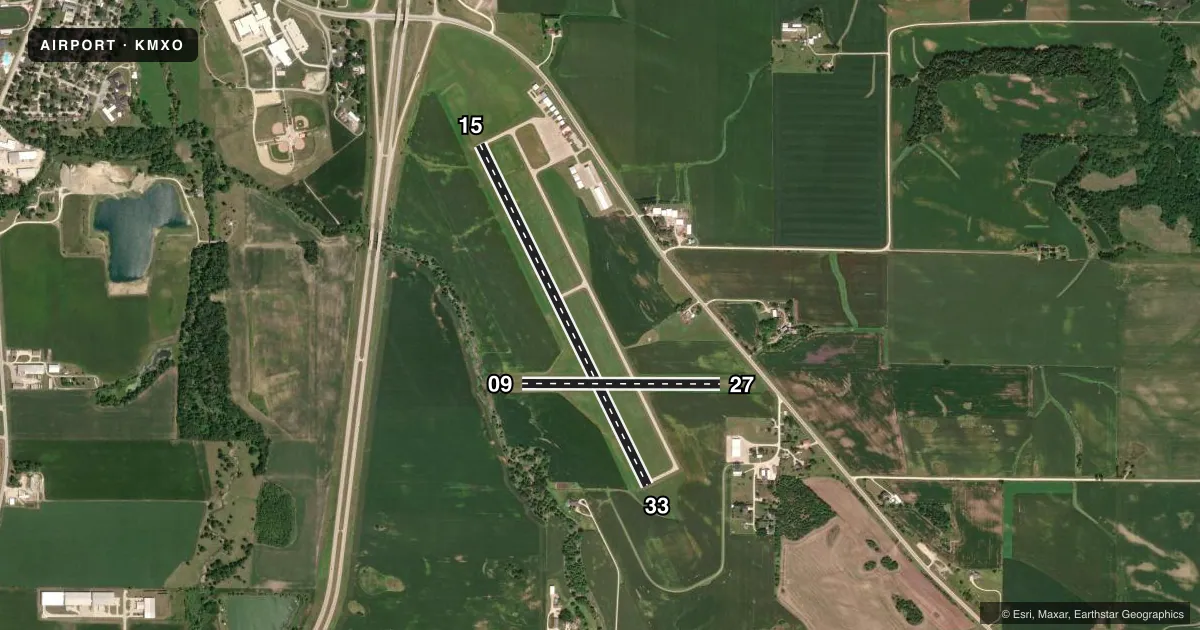
Runways & pattern
Full pagePattern entry · RWY 15
LEFT TRAFFIC| Runway | Heading (°M) | Length | Surface | Traffic |
|---|---|---|---|---|
| 15/33 | 153° / 333° | 4,400 ft | CONC | Standard L |
| 09/27 | 89° / 269° | 2,300 ft | TURF | Standard L |
Runway end performance
| End | TORA | TODA | ASDA | LDA | VGSI | Approach lights | Obstruction |
|---|---|---|---|---|---|---|---|
| 15 | — | — | — | — | PAPI 2-box left(3°) | — | 61', road, 1601' from thr, 171' R of cntrln, slope 22 |
| 33 | — | — | — | — | PAPI 2-box left(3°) | — | 97', trees, 3000' from thr, 137' R of cntrln, slope 28 |
| 09 | — | — | — | — | — | — | 23', trees, 429' from thr, 99' R of cntrln, slope 18 |
| 27 | — | — | — | — | — | — | 23', road, 513' from thr, 0' R of cntrln, slope 22 |
Declared distances in feet. TORA = takeoff run available, TODA = takeoff distance, ASDA = accelerate-stop, LDA = landing distance.
Airport sketch
Runways drawn to scale from FAA survey coordinates, rendered over satellite imagery. Not for navigation.
Approaches & charts
Services on the field
Fuel grades, oxygen, maintenance, ramp storage and lighting — as declared to the FAA by the airport operator.
Fuel & services
- Fuel
- 100LLA
- Oxygen (bottled)
- Low pressure
- Oxygen (bulk)
- Not available
- Airframe repair
- Major
- Power plant repair
- Major
- Other services
- INSTR,RNTL
Ramp & ground
- Transient storage
- Tie-down
- Hangar
- Landing fee
- No fee published
- Customs
- Not available
- Lighting schedule
- SEE RMK
- Beacon schedule
- SS-SR
- Beacon
- White / Green (civil land)(WG)
- Wind indicator
- Lighted
- Segmented circle
- No
Fuel & FBOs
Cheapest 100LL and Jet A on the field and nearby. Always confirm with the FBO before taxi.
Airport notes
Surface conditions, obstructions, local procedures, lighting outages and other notes published with each FAA cycle.
General notes
- RY 33 IS CALM WIND RY.
- FOR CD CTC CHICAGO ARTCC AT 630-906-8921.
Lighting notes
- ACTVT MIRL RY 15/33; REIL AND PAPI RYS 15 & 33- CTAF.
Fuel notes
- 100LL24 HR SELF SVC FUEL.
Runway surface & condition
- 09/27RWY CLSD DEC 1 THROUGH APR 1.
Other notes
- MAINTAIN CLEAR APCH TO EACH RY FOR A 20:1 GLIDE SLOPE AND CLEAR TRANSITIONAL SFCS FOR A 7:1 SLOPE.
- 1FOR SVC AFT HRS CALL 563-543-0503. UNATNDD ALL MAJOR HOLS.
- MANAGERHOME PHONE 563-543-0503
VFR map & nearby airports
VFR sectional. Tap any ICAO chip to open that airport.
Key facts · KMXO
Answer card- ICAO
- KMXO
- Name
- MONTICELLO RGNL
- Location
- MONTICELLO, IOWA
- Elevation
- 833.3 ft MSL
- Traffic pattern altitude
- 1,833.3 ft MSL (1,000 AGL)
- Control tower
- Non-towered (use CTAF)
- Total runways
- 2
- Longest runway
- 15/33 · 4,400 ft
- Published ILS approaches
- 0
- Published frequencies
- 4
- Magnetic variation
- 1°
- Current flight rules
- MVFR
- Current wind
- 000° at 0 kt
- Favored runway now
- –
Monticello Rgnl Airport (KMXO) sits in Monticello, Iowa at 833.3 ft MSL. It has two runways. The longest is 15/33 at 4,400 ft. Runway 09/27 is 2,300 ft turf. The field is non-towered, so plan to use CTAF 122.8 for local traffic calls. No ILS approaches are published here.
Pattern altitude is not published. Use the standard 1,000 ft AGL unless the current Chart Supplement says otherwise. That puts the light piston pattern at about 1,833 ft MSL based on the listed field elevation. Runway 33 is the calm wind runway. Runway 09/27 is closed from December 1 through April 1, so winter planning matters here.
Monticello Aviation is on the field. It carries 100LL and Jet A. Twenty-four hour self-serve fuel is available for 100LL. Runway 15/33 has medium intensity lights. REILs and PAPI are on runways 15 and 33. The airport is unattended on major holidays. For after-hours service, call the number in the Chart Supplement or the airport operator. If you need clearance delivery, contact Chicago ARTCC. Watch the approach and transitional surfaces. The published remarks call for clear approaches and clear transitional surfaces, so keep that in mind when planning arrivals and departures.