METAR & TAF KDBQ
Current METAR
Observed 17:53Z
KDBQ 261753Z 23004KT 8SM SCT012 30/27 A2990 RMK AO2 SLP118 T03000267 10300 20239 58005 $
- Wind
- 230° @ 4 kt
- Visibility
- 8 SM
- Temp / Dew
- 30°C / 27°C
- Altimeter
- 29.90 inHg
- Clouds
- SCT
- Density alt
- 3,160 ft
- Ceiling
- Unlimited
- Rules
- VFR
Airport info & contacts
Manager on record, flight service, ARTCC, attendance schedule and pattern altitude — published by the FAA and refreshed every 28 days.
Location
- From city
- 7 NM SW
- VFR sectional
- CHICAGO
- ARTCC
- ZAU · CHICAGO
- NOTAM facility
- DBQ (NOTAM-D)
Airport manager
- Name
- TODD DALSING
- Phone
- 563-589-4136
- Address
- 11000 AIRPORT ROAD, DUBUQUE IA 52003
Flight service · Hours
- FSS FOD
- FORT DODGE1-800-WX-BRIEF
- Attendance
- 0600-2200
Frequencies
Tap any row to copy the frequency to your clipboard.
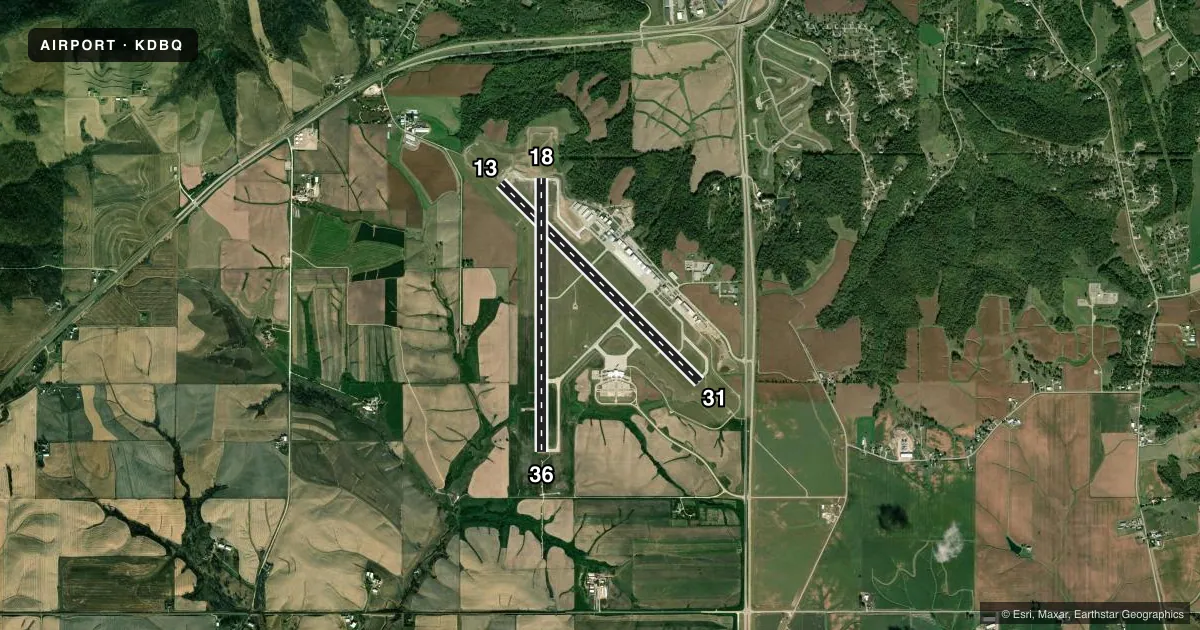
Runways & pattern
Full pagePattern entry · RWY 18
LEFT TRAFFIC| Runway | Heading (°M) | Length | Surface | Traffic |
|---|---|---|---|---|
| 13/31 | 132° / 312° | 6,502 ft | CONC | Standard L |
| 18/36Favored | 177° / 357° | 6,327 ft | CONC | Standard L |
Runway end performance
| End | TORA | TODA | ASDA | LDA | VGSI | Approach lights | Obstruction |
|---|---|---|---|---|---|---|---|
| 13 | 6,502' | 6,502' | 6,502' | 6,502' | PAPI 4-box right(3°) | MALS | — |
| 31 | 6,502' | 6,502' | 6,502' | 6,502' | PAPI 4-box left(3°) | MALSR | 122', pole, 4475' from thr, 50' R of cntrln, slope 35 |
| 18 | 6,327' | 6,327' | 6,327' | 6,327' | PAPI 4-box left(3°) | — | — |
| 36 | 6,327' | 6,327' | 6,327' | 6,327' | PAPI 4-box left(3°) | MALSR | — |
Declared distances in feet. TORA = takeoff run available, TODA = takeoff distance, ASDA = accelerate-stop, LDA = landing distance.
Airport sketch
Runways drawn to scale from FAA survey coordinates, rendered over satellite imagery. Not for navigation.
Approaches & charts
ILS · 2
Services on the field
Fuel grades, oxygen, maintenance, ramp storage and lighting — as declared to the FAA by the airport operator.
Fuel & services
- Fuel
- 100LLA1+
- Oxygen (bottled)
- High pressure
- Oxygen (bulk)
- High pressure
- Airframe repair
- Major
- Power plant repair
- Major
- Other services
- AFRT,CHTR,INSTR,RNTL,SALES
Ramp & ground
- Transient storage
- Tie-down
- Hangar
- Landing fee
- No fee published
- Customs
- Not available
- Lighting schedule
- SEE RMK
- Beacon schedule
- SEE RMK
- Beacon
- White / Green (civil land)(WG)
- Wind indicator
- Lighted
- Segmented circle
- No
Fuel & FBOs
Cheapest 100LL and Jet A on the field and nearby. Always confirm with the FBO before taxi.
Airport notes
Surface conditions, obstructions, local procedures, lighting outages and other notes published with each FAA cycle.
General notes
- WATERFOWL ON & INVOF ARPT.
- 100LL SELF SERVICE FUEL STATION AVBL AT T-HGRS 24HRS. AREA NOT VSB BY TWR.
- ACFT DEPARTING RY 36, THE APCH ENDS OF RY 31 AND RY 18 ARE NOT VISIBLE FOR APRXLY THE FIRST 3000 FT OF TKOF ROLL.
- FOR CD IF UNA TO CTC ON FSS FREQ, CTC CHICAGO ARTCC AT 630-906-8921.
- DASHED TWY EDGE MARKING ADJ TO TWY A EDGE AND GA APN DEFINE THE MOVMT/NON-MOVMT AREA BNDRY. NON-MOVMT AREA BNDRY MARKING ON THE GA APNS ARE THE WINGTIP CLNC LINE - TOFA BNDRY.
- PPR FOR UNSCHD ACR OPNS CALL AMGR (563) 589-4136. ARFF INDEX B LEVEL EQUIP IS PROVIDED.
Lighting notes
- ATC-CTL
- WHEN ATCT CLSD ACTVT MALSR RWYS 31 & 36; MALS RWY 13; REIL RWY 18; PAPI RWYS 13, 18, 31 & 36; HIRL RWYS 13/31 & 18/36 - CTAF.
Fuel notes
- 100LLFUEL SVC AVBL 24 HRS. FOR FUEL 2200-0500 CALL 563-589-4136.
Runway surface & condition
- 13/31PCR VALUE: 482/R/D/W/T
- 18/36PCR VALUE: 440/R/D/W/T
VFR map & nearby airports
VFR sectional. Tap any ICAO chip to open that airport.
Key facts · KDBQ
Answer card- ICAO
- KDBQ
- Name
- DUBUQUE RGNL
- Location
- DUBUQUE, IOWA
- Elevation
- 1,076.4 ft MSL
- Traffic pattern altitude
- 2,076.4 ft MSL (1,000 AGL)
- Control tower
- Towered · 0600-2200
- Total runways
- 2
- Longest runway
- 13/31 · 6,502 ft
- Published ILS approaches
- 2
- Published frequencies
- 6
- Magnetic variation
- 3°
- Current flight rules
- VFR
- Current wind
- 230° at 4 kt
- Favored runway now
- RWY 18
Dubuque Rgnl Airport sits in Dubuque, Iowa at 1,076.4 ft MSL. It has two concrete runways. The longest is 13/31 at 6,502 ft. The other runway is 18/36 at 6,327 ft. The field is towered from 0600 to 2200. When the tower is closed, lighting is activated on CTAF. That matters here because the airport has approach lighting and runway end lighting tied to the published lighting system.
Two ILS approaches are published. They serve runways 31 and 36. The pattern altitude is not published in the facts, so a light piston pilot should verify the current pattern and any local procedures before arrival. The airport sits in a higher-elevation river valley setting for the region. Expect to pay attention to density altitude on warm days.
Dubuque Jet Center is on the field. It carries 100LL and Jet A. 100LL self-serve is available 24 hours at the T-hangars. The published remarks also say prior permission is required for unscheduled aircraft operations. Call the airport manager before you go if that applies to your flight. Waterfowl are reported on and near the airport, so keep that in mind on taxi, takeoff and landing. The remarks also note that runway 36 departures can have limited sightlines to the approach ends of runways 31 and 18 for the first 3,000 ft of the takeoff roll.