METAR & TAF 73C
73C does not publish a METAR.
Showing the nearest reporting station: KPVB (PLATTEVILLE MUNI) · 11.8 NM away. Conditions at 73C may differ.
METAR · KPVB
Observed 05:15Z
KPVB 270515Z AUTO 16005KT 1SM BKN002 A2985 RMK AO1
- Wind
- 160° @ 5 kt
- Visibility
- 1 SM
- Temp / Dew
- —
- Altimeter
- 29.85 inHg
- Clouds
- BKN
- Density alt
- —
- Ceiling
- 200 ft AGL
- Rules
- LIFR
Airport info & contacts
Manager on record, flight service, ARTCC, attendance schedule and pattern altitude — published by the FAA and refreshed every 28 days.
Location
- From city
- 4 NM S
- VFR sectional
- CHICAGO
- ARTCC
- ZAU · CHICAGO
- NOTAM facility
- GRB (NOTAM-D)
Airport manager
- Name
- JOHN HAUTH
- Phone
- 608-723-7543
- Address
- 206 S MADISON STREET, LANCASTER WI 53813
Flight service · Hours
- FSS GRB
- GREEN BAY1-800-WX-BRIEF
- Attendance
- Unattended
Frequencies
Tap any row to copy the frequency to your clipboard.
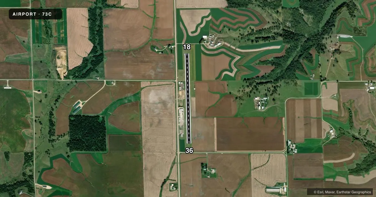
Runways & pattern
Full pagePattern entry · RWY 18
LEFT TRAFFICRunway end performance
| End | TORA | TODA | ASDA | LDA | VGSI | Approach lights | Obstruction |
|---|---|---|---|---|---|---|---|
| 18 | — | — | — | — | — | — | 10', road, 350' from thr, 0' R of cntrln, slope 15 |
| 36 | — | — | — | — | — | — | 15', road, 325' from thr, 0' R of cntrln, slope 8 |
Declared distances in feet. TORA = takeoff run available, TODA = takeoff distance, ASDA = accelerate-stop, LDA = landing distance.
Airport sketch
Runways drawn to scale from FAA survey coordinates, rendered over satellite imagery. Not for navigation.
Approaches & charts
Services on the field
Fuel grades, oxygen, maintenance, ramp storage and lighting — as declared to the FAA by the airport operator.
Fuel & services
- Fuel
- 100LL
Ramp & ground
- Transient storage
- Hangar
- Landing fee
- No fee published
- Customs
- Not available
- Lighting schedule
- SS-SR
- Beacon schedule
- SS-SR
- Beacon
- White / Green (civil land)(WG)
- Wind indicator
- Lighted
- Segmented circle
- No
Fuel & FBOs
Cheapest 100LL and Jet A on the field and nearby. Always confirm with the FBO before taxi.
Airport notes
Surface conditions, obstructions, local procedures, lighting outages and other notes published with each FAA cycle.
General notes
- OCNL VEHICLES/PEOPLE CROSSING RY TO REACH HGR AREA ON EAST SIDE OF RY.
- FOR CD CTC CHICAGO ARTCC AT 630-906-8921.
Fuel notes
- 100LL24 HR SELF SVC FUEL AVBL WITH CREDIT CARD.
Other notes
- DETERMINATION PENDING.
- MANAGEREMAIL ADDRESS: JOHNH@LANCASTERWISCONSIN.COM (ALL LOWER CASE)
VFR map & nearby airports
VFR sectional. Tap any ICAO chip to open that airport.
Key facts · 73C
Answer card- ICAO
- 73C
- Name
- LANCASTER MUNI
- Location
- LANCASTER, WISCONSIN
- Elevation
- 1,015.6 ft MSL
- Traffic pattern altitude
- 2,015.6 ft MSL (1,000 AGL)
- Control tower
- Non-towered (use CTAF)
- Total runways
- 1
- Longest runway
- 18/36 · 3,300 ft
- Published ILS approaches
- 0
- Published frequencies
- 2
- Magnetic variation
- 1°
- Current flight rules
- LIFR
- Current wind
- 160° at 5 kt
- Favored runway now
- RWY 18
Lancaster Muni sits in Lancaster, Wisconsin. The field elevation is 1,015.6 ft MSL. It has one runway, 18/36, which is 3,300 ft long and paved. The airport is non-towered. CTAF and UNICOM are both 122.8. No ILS approaches are published here.
The pattern altitude is not published. Use the standard 1,000 ft AGL pattern unless the current Chart Supplement says otherwise. That puts the light-piston pattern at about 2,015.6 ft MSL based on the field elevation. The on-field FBO is Lancaster Municipal Airport. It carries 100LL. Twenty-four hour self-service fuel is available with credit card. Call the airport at (608) 723-7543 if you need current ramp or fuel details.
A first-time pilot should watch for occasional vehicles and people crossing the runway to reach the hangar area on the east side. That makes a good traffic scan important on every leg. For clearance delivery, contact Chicago ARTCC at 630-906-8921. The airport manager email is listed in the Chart Supplement if you need local coordination before arrival.