METAR & TAF Y51
Current METAR
Observed 06:15Z
KY51 170615Z AUTO 16007KT 5SM SCT032 BKN060 OVC065 18/11 A2986 RMK AO1 T01760107
- Wind
- 160° @ 7 kt
- Visibility
- 5 SM
- Temp / Dew
- 18°C / 11°C
- Altimeter
- 29.86 inHg
- Clouds
- OVC
- Density alt
- 2,036 ft
- Ceiling
- 6,000 ft AGL
- Rules
- MVFR
Airport info & contacts
Manager on record, flight service, ARTCC, attendance schedule and pattern altitude — published by the FAA and refreshed every 28 days.
Location
- From city
- 2 NM N
- VFR sectional
- CHICAGO
- ARTCC
- ZMP · MINNEAPOLIS
- NOTAM facility
- GRB (NOTAM-D)
Airport manager
- Name
- MICHAEL OLSON
- Phone
- 608-606-9563
- Address
- 124 W DECKER ST, VIROQUA WI 54665
Flight service · Hours
- FSS GRB
- GREEN BAY1-800-WX-BRIEF
- Attendance
- Unattended
Frequencies
Tap any row to copy the frequency to your clipboard.
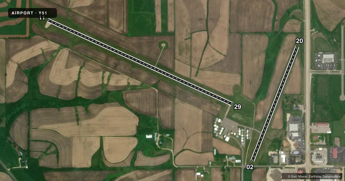
Runways & pattern
Full pagePattern entry · RWY 20
LEFT TRAFFIC| Runway | Heading (°M) | Length | Surface | Traffic |
|---|---|---|---|---|
| 11/29 | 114° / 294° | 4,000 ft | ASPH | Standard L |
| 02/20Favored | 22° / 202° | 2,424 ft | TURF | Standard L |
Runway end performance
| End | TORA | TODA | ASDA | LDA | VGSI | Approach lights | Obstruction |
|---|---|---|---|---|---|---|---|
| 11 | — | — | — | — | PAPI 2-box left(3°) | — | — |
| 29 | — | — | — | — | PAPI 2-box left(3°) | — | — |
Declared distances in feet. TORA = takeoff run available, TODA = takeoff distance, ASDA = accelerate-stop, LDA = landing distance.
Airport sketch
Runways drawn to scale from FAA survey coordinates, rendered over satellite imagery. Not for navigation.
Approaches & charts
Services on the field
Fuel grades, oxygen, maintenance, ramp storage and lighting — as declared to the FAA by the airport operator.
Fuel & services
- Fuel
- 100LL
- Oxygen (bottled)
- Not available
- Oxygen (bulk)
- Not available
- Airframe repair
- Not available
- Power plant repair
- Not available
- Other services
- INSTR
Ramp & ground
- Transient storage
- Tie-down
- Landing fee
- No fee published
- Lighting schedule
- SEE RMK
- Wind indicator
- Lighted
- Segmented circle
- Yes
Fuel & FBOs
Cheapest 100LL and Jet A on the field and nearby. Always confirm with the FBO before taxi.
Airport notes
Surface conditions, obstructions, local procedures, lighting outages and other notes published with each FAA cycle.
General notes
- FOR CD CTC MINNEAPOLIS ARTCC AT 651-463-5588.
Lighting notes
- MIRL RWY 11/29 PRESET TO LOW SS-SR; TO INCR INTST AND ACTVT REIL 11 & 29; PAPI RWY 11 & 29; MIRL RWY 11/29 - CTAF.
Fuel notes
- 100LL24 HR FUEL AVBL WITH CREDIT CARD.
Runway surface & condition
- 02/20CLSD NOV 15 THRU APR 15.
- 02/20HAS SHARP 20 FT DROP-OFF EA END & SLOPES DOWNHILL TO THE NORTH APRXLY 1.5%.
Approach & departure obstructions
- 02MKD WITH YELLOW CONES.
- 20MKD WITH YELLOW CONES.
- 29PAPI UNUSBL BYD 5 DEG L OF CNTRLN.
VFR map & nearby airports
VFR sectional. Tap any ICAO chip to open that airport.
Key facts · Y51
Answer card- ICAO
- Y51
- Name
- VIROQUA MUNI
- Location
- VIROQUA, WISCONSIN
- Elevation
- 1,292 ft MSL
- Traffic pattern altitude
- 2,292 ft MSL (1,000 AGL)
- Control tower
- Non-towered (use CTAF)
- Total runways
- 2
- Longest runway
- 11/29 · 4,000 ft
- Published ILS approaches
- 0
- Published frequencies
- 1
- Magnetic variation
- 0°
- Current flight rules
- MVFR
- Current wind
- 160° at 7 kt
- Favored runway now
- RWY 20
Viroqua Muni sits in Viroqua, Wisconsin at 1,292 ft MSL. It has two runways. The longest is 11/29 at 4,000 ft asphalt. Runway 02/20 is 2,424 ft turf. There is no control tower. CTAF is 122.9.
No ILS approaches are published here. Pattern altitude is not published, so use the standard 1,000 ft AGL for light piston ops unless the current Chart Supplement says otherwise. The on-field FBO is Viroqua Municipal Airport. It carries 100LL. 24-hour fuel is available with credit card.
A few runway notes matter here. Runway 02/20 is closed from November 15 through April 15. It also has a sharp 20-foot drop-off at each end. It slopes downhill to the north about 1.5 percent. Runway 02 and runway 20 are marked with yellow cones. Runway 11 has a 6-foot sign 50 feet from the threshold, 160 feet left of centerline. The PAPI on runway 29 is unusable beyond 5 degrees left of centerline. Runway 11/29 has medium intensity lights that sit at low preset from sunset to sunrise. Use the CTAF to increase intensity and to turn on the runway end identifier lights.
For a first-time arrival, the main things are the turf closure dates, the runway slope and the lighting setup on 11/29. Check the current Chart Supplement for any updates before you go.