METAR & TAF KBCK
Current METAR
Observed 10:15Z
KBCK 271015Z 00000KT 1/4SM FG 21/21 A2976 RMK AO2 T02120212
- Wind
- 000° @ 0 kt
- Visibility
- 0.25 SM
- Temp / Dew
- 21°C / 21°C
- Altimeter
- 29.76 inHg
- Clouds
- Clear
- Density alt
- 1,955 ft
- Ceiling
- Unlimited
- Rules
- LIFR
Airport info & contacts
Manager on record, flight service, ARTCC, attendance schedule and pattern altitude — published by the FAA and refreshed every 28 days.
Location
- From city
- 3 NM S
- VFR sectional
- GREEN BAY
- ARTCC
- ZMP · MINNEAPOLIS
- NOTAM facility
- GRB (NOTAM-D)
Airport manager
- Name
- FRANK VOGE
- Phone
- 920-960-1519
- Address
- 101 S. SECOND ST, BLACK RIVER FALLS WI 54615
Flight service · Hours
- FSS GRB
- GREEN BAY1-800-WX-BRIEF
- Attendance
- Unattended
Frequencies
Tap any row to copy the frequency to your clipboard.
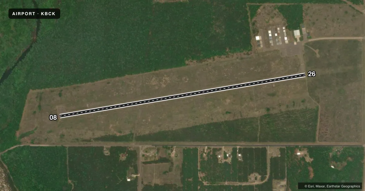
Runways & pattern
Full pagePattern entry · RWY 08
LEFT TRAFFICRunway end performance
| End | TORA | TODA | ASDA | LDA | VGSI | Approach lights | Obstruction |
|---|---|---|---|---|---|---|---|
| 08 | — | — | — | — | PAPI 2-box left(3°) | — | 25', tree, 340' from thr, 235' R of cntrln, slope 5 |
| 26 | — | — | — | — | PAPI 2-box left(3.5°) | — | 43', tree, 1510' from thr, 160' R of cntrln, slope 30 |
Declared distances in feet. TORA = takeoff run available, TODA = takeoff distance, ASDA = accelerate-stop, LDA = landing distance.
Airport sketch
Runways drawn to scale from FAA survey coordinates, rendered over satellite imagery. Not for navigation.
Approaches & charts
Services on the field
Fuel grades, oxygen, maintenance, ramp storage and lighting — as declared to the FAA by the airport operator.
Fuel & services
- Fuel
- 100LLA+
- Other services
- INSTR
Ramp & ground
- Transient storage
- Tie-down
- Landing fee
- No fee published
- Customs
- Not available
- Lighting schedule
- SEE RMK
- Beacon schedule
- SS-SR
- Beacon
- White / Green (civil land)(WG)
- Wind indicator
- Lighted
- Segmented circle
- No
Fuel & FBOs
Cheapest 100LL and Jet A on the field and nearby. Always confirm with the FBO before taxi.
Airport notes
Surface conditions, obstructions, local procedures, lighting outages and other notes published with each FAA cycle.
General notes
- BIRDS & WILDLIFE ON & INVOF ARPT.
- FOR CD IF UNA TO CTC ON FSS FREQ, CTC MINNEAPOLIS ARTCC AT 651-463-5588.
Lighting notes
- ACTVT REIL RWY 08 & 26; PAPI RWY 08 & 26; MIRL RWY 08/26 - CTAF. SS-SR MIRL RWY 08/26 PRESET TO LOW INTST; INCR INTST - CTAF.
Fuel notes
- 100LLSELF SVC H24 WITH CREDIT CARD.
VFR map & nearby airports
VFR sectional. Tap any ICAO chip to open that airport.
Key facts · KBCK
Answer card- ICAO
- KBCK
- Name
- BLACK RIVER FALLS AREA
- Location
- BLACK RIVER FALLS, WISCONSIN
- Elevation
- 836.2 ft MSL
- Traffic pattern altitude
- 1,836.2 ft MSL (1,000 AGL)
- Control tower
- Non-towered (use CTAF)
- Total runways
- 1
- Longest runway
- 08/26 · 4,601 ft
- Published ILS approaches
- 0
- Published frequencies
- 1
- Magnetic variation
- 0°
- Current flight rules
- LIFR
- Current wind
- 000° at 0 kt
- Favored runway now
- –
Black River Falls Area Airport sits in Black River Falls, Wisconsin. Field elevation is 836.2 ft MSL. The airport has one runway. Runway 08/26 is 4,601 ft long with an asphalt surface. There is no control tower. CTAF is 122.9.
No ILS approaches are published here. Runway 08 and runway 26 both have runway end identifier lights and PAPI. Medium intensity runway lights are installed on 08/26 and are controlled by CTAF. From sunset to sunrise, the lights are preset to low intensity. Use CTAF to increase intensity if needed. The published remarks also note birds and wildlife on and near the airport. That is worth planning for on arrival and departure.
The on-field FBO is Black River Falls Area Airport. It carries AVGAS 100LL and JET A. Self-service 100LL is available 24 hours with a credit card. Clearance delivery can be coordinated through Minneapolis ARTCC if Flight Service cannot be reached on the usual frequency. Pattern altitude is not published. Use the standard 1,000 ft AGL pattern unless the current Chart Supplement says otherwise. For a light piston arrival, that puts you at about 1,836.2 ft MSL.