METAR & TAF KMFI
Current METAR
Observed 08:54Z
KMFI 270854Z AUTO 00000KT 6SM BR SCT032 23/23 A2980 RMK AO2 SLP082 T02330228 55012
- Wind
- 000° @ 0 kt
- Visibility
- 6 SM
- Temp / Dew
- 23°C / 23°C
- Altimeter
- 29.80 inHg
- Clouds
- SCT
- Density alt
- 2,693 ft
- Ceiling
- Unlimited
- Rules
- VFR
Airport info & contacts
Manager on record, flight service, ARTCC, attendance schedule and pattern altitude — published by the FAA and refreshed every 28 days.
Location
- From city
- 1 NM S
- VFR sectional
- GREEN BAY
- ARTCC
- ZMP · MINNEAPOLIS
- NOTAM facility
- MFI (NOTAM-D)
Airport manager
- Name
- JEFF GAIER
- Phone
- 715-387-2211
- Address
- 400 W 29TH ST, MARSHFIELD WI 54449
Flight service · Hours
- FSS GRB
- GREEN BAY1-800-WX-BRIEF
- Attendance
- MON-SAT · 0800-1700
Frequencies
Tap any row to copy the frequency to your clipboard.
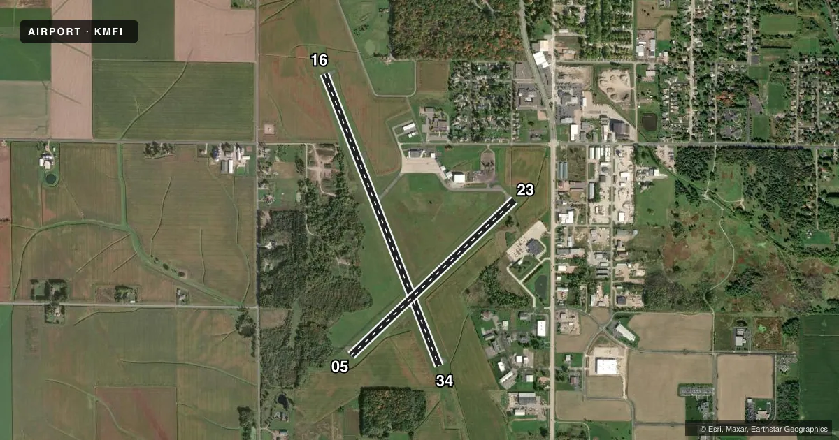
Runways & pattern
Full pagePattern entry · RWY 16
RIGHT TRAFFIC| Runway | Heading (°M) | Length | Surface | Traffic |
|---|---|---|---|---|
| 16/34 | 159° / 339° | 5,003 ft | ASPH | 16 R |
| 05/23 | 46° / 227° | 3,600 ft | ASPH | 05 R |
Runway end performance
| End | TORA | TODA | ASDA | LDA | VGSI | Approach lights | Obstruction |
|---|---|---|---|---|---|---|---|
| 16 | — | — | — | — | VASI 2-box left(3°) | — | 120', trees, 2280' from thr, 580' R of cntrln, slope 17 |
| 34 | — | — | — | — | VASI 2-box left(3°) | MALSR | 15', trees, 230' from thr, 480' R of cntrln, slope 2 |
| 05 | — | — | — | — | PAPI 2-box left(3°) | — | 35', trees, 500' from thr, 200' R of cntrln, slope 8 |
Declared distances in feet. TORA = takeoff run available, TODA = takeoff distance, ASDA = accelerate-stop, LDA = landing distance.
Airport sketch
Runways drawn to scale from FAA survey coordinates, rendered over satellite imagery. Not for navigation.
Approaches & charts
Services on the field
Fuel grades, oxygen, maintenance, ramp storage and lighting — as declared to the FAA by the airport operator.
Fuel & services
- Fuel
- 100LLA+
- Oxygen (bottled)
- Not available
- Oxygen (bulk)
- Not available
- Airframe repair
- Major
- Power plant repair
- Minor
- Other services
- AMB,CHTR,INSTR,RNTL
Ramp & ground
- Transient storage
- Tie-down
- Hangar
- Landing fee
- No fee published
- Customs
- Not available
- Lighting schedule
- SEE RMK
- Beacon schedule
- SS-SR
- Beacon
- White / Green (civil land)(WG)
- Wind indicator
- Lighted
- Segmented circle
- No
Fuel & FBOs
Cheapest 100LL and Jet A on the field and nearby. Always confirm with the FBO before taxi.
Airport notes
Surface conditions, obstructions, local procedures, lighting outages and other notes published with each FAA cycle.
General notes
- BIRDS, WATERFOWL & DEER ON & INVOF ARPT.
- RY 34 DEPARTING ACFT CLIMB TO 2000 FT MSL PRIOR TO INITIATING RIGHT TURN.
- FOR CD IF UNA TO CTC ON FSS FREQ, CTC MINNEAPOLIS ARTCC AT 651-463-5588.
Lighting notes
- MIRL RWY 05/23 & RWY 16/34 PRESET TO LOW SS-SR; TO INCR INTST AND ACTVT MALSR RWY 34; REIL RWY 16; VASI RWY 16 & 34; PAPI RWY 05; MIRL RWY 5/23 & RWY 16/34 - CTAF.
Fuel notes
- 100LL24 HR FUEL AVBL WITH CREDIT CARD.
Other notes
- 1FOR AFT HRS SVC CALL 715-743-6634.
VFR map & nearby airports
VFR sectional. Tap any ICAO chip to open that airport.
Key facts · KMFI
Answer card- ICAO
- KMFI
- Name
- MARSHFIELD MUNI
- Location
- MARSHFIELD, WISCONSIN
- Elevation
- 1,277.8 ft MSL
- Traffic pattern altitude
- 2,277.8 ft MSL (1,000 AGL)
- Control tower
- Non-towered (use CTAF)
- Total runways
- 2
- Longest runway
- 16/34 · 5,003 ft
- Published ILS approaches
- 0
- Published frequencies
- 2
- Magnetic variation
- 0°
- Current flight rules
- VFR
- Current wind
- 000° at 0 kt
- Favored runway now
- –
Marshfield Muni is in Marshfield, Wisconsin. The field elevation is 1,277.8 ft MSL. It has two asphalt runways. The longest is 5,003 ft on runway 16/34. This is an untowered field, so expect self-announce traffic on CTAF 123.0 and UNICOM 123.0.
No ILS approaches are published here. Pattern altitude is not published in the facts. Use the standard 1,000 ft AGL for light piston operations unless current airport information says otherwise. Duffys Aircraft Sales & Leasing is on the field. It carries 100LL and Jet A. 24-hour fuel is available with credit card. For after-hours service, the published number is available in the Chart Supplement and airport remarks.
A few operational items matter here. Runway lights are preset low from sunset to sunrise. Use CTAF to increase intensity and to activate the approach lighting and runway visual aids. Aircraft departing runway 34 must climb to 2,000 ft MSL before starting a right turn. Birds, waterfowl and deer are reported on and near the airport. If you need clearance delivery and cannot raise flight service, the published remark says to contact Minneapolis ARTCC at 651-463-5588. Check the current Chart Supplement before flying in for any updated procedures.