METAR & TAF KAUW
Current METAR
Observed 14:54Z
KAUW 271454Z AUTO 15005KT 10SM OVC025 27/24 A2969 RMK AO2 LTG DSNT N-E SLP049 T02670239 58017
- Wind
- 150° @ 5 kt
- Visibility
- 10 SM
- Temp / Dew
- 27°C / 24°C
- Altimeter
- 29.69 inHg
- Clouds
- OVC
- Density alt
- 3,214 ft
- Ceiling
- 2,500 ft AGL
- Rules
- MVFR
Airport info & contacts
Manager on record, flight service, ARTCC, attendance schedule and pattern altitude — published by the FAA and refreshed every 28 days.
Location
- From city
- 0 NM S
- VFR sectional
- GREEN BAY
- ARTCC
- ZMP · MINNEAPOLIS
- NOTAM facility
- AUW (NOTAM-D)
Airport manager
- Name
- JOHN P CHMIEL
- Phone
- 715-845-3400
- Address
- 725 WOODS PLACE, WAUSAU WI 54401
Flight service · Hours
- FSS GRB
- GREEN BAY1-800-WX-BRIEF
- Attendance
- 0800-1700
Frequencies
Tap any row to copy the frequency to your clipboard.
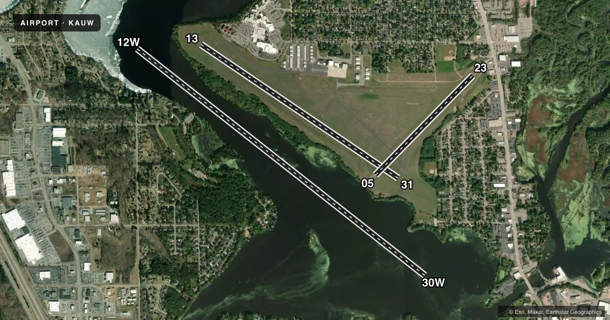
Runways & pattern
Full pagePattern entry · RWY 12W
LEFT TRAFFIC| Runway | Heading (°M) | Length | Surface | Traffic |
|---|---|---|---|---|
| 12W/30WFavored | 125° / 305° | 8,000 ft | WATER | Standard L |
| 13/31 | 121° / 301° | 5,200 ft | ASPH | Standard L |
| 05/23 | 41° / 221° | 3,041 ft | ASPH | Standard L |
Runway end performance
| End | TORA | TODA | ASDA | LDA | VGSI | Approach lights | Obstruction |
|---|---|---|---|---|---|---|---|
| 13 | — | — | — | — | PAPI 4-box left(3°) | — | 34', trees, 250' from thr, 410' R of cntrln, slope 1 |
| 31 | — | — | — | — | PAPI 4-box left(3°) | — | 38', trees, 225' from thr, 375' R of cntrln, slope 0 |
Declared distances in feet. TORA = takeoff run available, TODA = takeoff distance, ASDA = accelerate-stop, LDA = landing distance.
Airport sketch
Runways drawn to scale from FAA survey coordinates, rendered over satellite imagery. Not for navigation.
Approaches & charts
Services on the field
Fuel grades, oxygen, maintenance, ramp storage and lighting — as declared to the FAA by the airport operator.
Fuel & services
- Fuel
- 100LLA+MOGAS
- Airframe repair
- Major
- Power plant repair
- Major
- Other services
- INSTR,RNTL
Ramp & ground
- Transient storage
- Tie-down
- Hangar
- Landing fee
- No fee published
- Lighting schedule
- SEE RMK
- Beacon schedule
- SS-SR
- Beacon
- White / Green (civil land)(WG)
- Wind indicator
- Lighted
- Segmented circle
- Yes
Fuel & FBOs
Cheapest 100LL and Jet A on the field and nearby. Always confirm with the FBO before taxi.
Airport notes
Surface conditions, obstructions, local procedures, lighting outages and other notes published with each FAA cycle.
General notes
- FOR CD IF UNA TO CTC ON FSS FREQ, CTC MINNEAPOLIS ARTCC AT 651-463-5588.
Lighting notes
- MIRL RWY 13/31 PRESET TO LOW; TO INCR INTST AND ACTVT REILS RWY 13 & 31; PAPI RWY 13 & 31; MIRL RWY 5/23 - CTAF.
Approach & departure obstructions
- 1340 FT TREES 0-200 FT FM THR 300 FT R & 450 FT L.
- 3130 FT TREES 150 FT FM THR 425 FT L.
VFR map & nearby airports
VFR sectional. Tap any ICAO chip to open that airport.
Key facts · KAUW
Answer card- ICAO
- KAUW
- Name
- WAUSAU DOWNTOWN
- Location
- WAUSAU, WISCONSIN
- Elevation
- 1,201 ft MSL
- Traffic pattern altitude
- 2,201 ft MSL (1,000 AGL)
- Control tower
- Non-towered (use CTAF)
- Total runways
- 3
- Longest runway
- 12W/30W · 8,000 ft
- Published ILS approaches
- 0
- Published frequencies
- 2
- Magnetic variation
- 3°
- Current flight rules
- MVFR
- Current wind
- 150° at 5 kt
- Favored runway now
- RWY 12W
Wausau Downtown Airport (KAUW) sits in Wausau, Wisconsin at 1,201 ft MSL. It has three runways. The longest is 12W/30W at 8,000 ft on water. The paved runways are 13/31 at 5,200 ft and 05/23 at 3,041 ft. There is no control tower. CTAF and UNICOM are both 122.7.
No ILS approaches are published here. Pattern altitude is not published, so use the standard 1,000 ft AGL for light piston operations unless the current Chart Supplement says otherwise. That puts the usual traffic pattern around 2,201 ft MSL based on the field elevation.
Wausau Flying Service is on the field. It carries 100LL, Jet A and mogas. Call (715) 845-3400 for current service details before you go. Published remarks also note that runway 13/31 lighting is pilot-controlled. The runway edge lights start at low intensity. PCL also brings on the runway end identifier lights for 13 and 31. Runway 5/23 lighting is also pilot-controlled on the common traffic advisory frequency.
Watch the obstructions near runway 13 and runway 31. Trees sit close to both thresholds. If you need clearance delivery and cannot reach Flight Service, Minneapolis Center is listed as the backup contact. For any current noise, lighting, or operational changes, check the current FAA Chart Supplement before departure.