METAR & TAF KEZS
Current METAR
Observed 13:15Z
KEZS 271315Z AUTO 00000KT 10SM BKN009 OVC015 26/22 A2975 RMK AO2 LTG DSNT N T02560222
- Wind
- 000° @ 0 kt
- Visibility
- 10 SM
- Temp / Dew
- 26°C / 22°C
- Altimeter
- 29.75 inHg
- Clouds
- OVC
- Density alt
- 2,539 ft
- Ceiling
- 900 ft AGL
- Rules
- IFR
Airport info & contacts
Manager on record, flight service, ARTCC, attendance schedule and pattern altitude — published by the FAA and refreshed every 28 days.
Location
- From city
- 1 NM NE
- VFR sectional
- GREEN BAY
- ARTCC
- ZMP · MINNEAPOLIS
- NOTAM facility
- GRB (NOTAM-D)
Airport manager
- Name
- KYLE HOTVEDT
- Phone
- 715-526-2465
- Address
- 248 AIRPORT RD, SHAWANO WI 54166
Flight service · Hours
- FSS GRB
- GREEN BAY1-800-WX-BRIEF
- Attendance
- MON-FRI · 0800-1630
- SAT-SUN · ON CALL
Frequencies
Tap any row to copy the frequency to your clipboard.
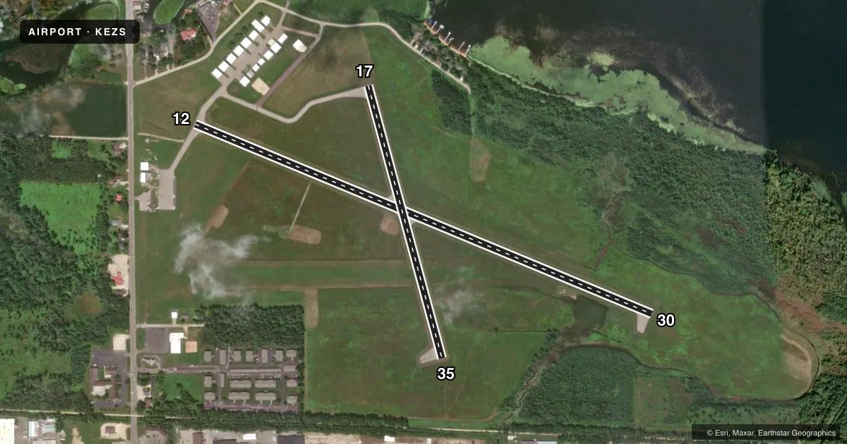
Runways & pattern
Full pagePattern entry · RWY 12
LEFT TRAFFIC| Runway | Heading (°M) | Length | Surface | Traffic |
|---|---|---|---|---|
| 12/30 | 111° / 291° | 3,901 ft | ASPH | Standard L |
| 17/35 | 163° / 343° | 2,225 ft | ASPH | Standard L |
Runway end performance
| End | TORA | TODA | ASDA | LDA | VGSI | Approach lights | Obstruction |
|---|---|---|---|---|---|---|---|
| 12 | — | — | — | — | — | — | 14', road, 370' from thr, 260' R of cntrln, slope 12 |
| 30 | — | — | — | — | PAPI 2-box left(3°) | — | — |
| 35 | — | — | — | — | — | — | 39', tree, 600' from thr, 125' R of cntrln, slope 10 |
Declared distances in feet. TORA = takeoff run available, TODA = takeoff distance, ASDA = accelerate-stop, LDA = landing distance.
Airport sketch
Runways drawn to scale from FAA survey coordinates, rendered over satellite imagery. Not for navigation.
Approaches & charts
Services on the field
Fuel grades, oxygen, maintenance, ramp storage and lighting — as declared to the FAA by the airport operator.
Fuel & services
- Fuel
- 100LL
- Other services
- INSTR
Ramp & ground
- Transient storage
- Tie-down
- Hangar
- Landing fee
- No fee published
- Customs
- Not available
- Lighting schedule
- SEE RMK
- Beacon schedule
- SS-SR
- Beacon
- White / Green (civil land)(WG)
- Wind indicator
- Lighted
- Segmented circle
- No
Fuel & FBOs
Cheapest 100LL and Jet A on the field and nearby. Always confirm with the FBO before taxi.
Airport notes
Surface conditions, obstructions, local procedures, lighting outages and other notes published with each FAA cycle.
General notes
- WATERFOWL & DEER ON & INVOF ARPT.
- SPB; CLSD EARLY NOV - EARLY MAY; BEACHING RAMP & TIE DOWNS AVBL; COND - AMGR.
- FOR CD CTC GREEN BAY APCH AT 920-431-5741. WHEN APCH CLSD, CTC MINNEAPOLIS ARTCC AT 651-463-5588.
Lighting notes
- ACTVT REIL RWY 30; MIRL RWY 12/30 & 17/35 - CTAF. PAPI RWY 30 OPR CONSLY. SS-SR: MIRL RWY 12/30 PRESET LOW INTST; INCR INTST - CTAF.
Fuel notes
- 100LLSELF SVC H24 WITH CREDIT CARD.
Approach & departure obstructions
- 30PAPI UNUSBL BYD 9 DEGS LEFT OF CNTRLN.
Other notes
- 2715-584-1750
- MANAGER715-584-1750.
VFR map & nearby airports
VFR sectional. Tap any ICAO chip to open that airport.
Key facts · KEZS
Answer card- ICAO
- KEZS
- Name
- SHAWANO MUNI
- Location
- SHAWANO, WISCONSIN
- Elevation
- 813.1 ft MSL
- Traffic pattern altitude
- 1,813.1 ft MSL (1,000 AGL)
- Control tower
- Non-towered (use CTAF)
- Total runways
- 2
- Longest runway
- 12/30 · 3,901 ft
- Published ILS approaches
- 0
- Published frequencies
- 4
- Magnetic variation
- 2°
- Current flight rules
- IFR
- Current wind
- 000° at 0 kt
- Favored runway now
- –
Shawano Muni (KEZS) sits in Shawano, Wisconsin. Field elevation is 813.1 ft MSL. The airport has two asphalt runways. The longest is 3,901 ft on runway 12/30. There is no control tower. CTAF and UNICOM are both 122.8. No ILS approaches are published. Pattern altitude is not published, so plan on the standard 1,000 ft AGL for light piston traffic unless the current Chart Supplement says otherwise.
Runway 12/30 carries medium intensity lights. They are controlled by CTAF. The runway 30 PAPI runs continuously. Runway end identifier lights are activated on runway 30. The published remarks also note 24-hour self-serve 100LL with a credit card. Shawano Municipal Airport is the on-field FBO. It carries AVGAS 100LL.
This is a non-towered field with Green Bay Approach handling clearance delivery on 119.4 or 338.2. If approach is closed, use Minneapolis ARTCC. Watch for waterfowl and deer in the area. That matters here. The airport also has a seaplane base. Its seasonal status and ramp use should be confirmed with the airport manager before you plan on it. For first-time arrivals, the main things to brief are the lighting setup on 12/30, the wildlife and the fact that you will want current runway and approach information before you go.