METAR & TAF 7P5
7P5 does not publish a METAR.
Showing the nearest reporting station: KEZS (SHAWANO MUNI) · 17.7 NM away. Conditions at 7P5 may differ.
METAR · KEZS
Observed 03:35Z
KEZS 270335Z AUTO 00000KT 10SM 25/23 A2983 RMK AO2 LTG DSNT NE T02500225
- Wind
- 000° @ 0 kt
- Visibility
- 10 SM
- Temp / Dew
- 25°C / 23°C
- Altimeter
- 29.83 inHg
- Clouds
- Clear
- Density alt
- 2,421 ft
- Ceiling
- Unlimited
- Rules
- VFR
Airport info & contacts
Manager on record, flight service, ARTCC, attendance schedule and pattern altitude — published by the FAA and refreshed every 28 days.
Location
- From city
- 4 NM NW
- VFR sectional
- GREEN BAY
- Pattern altitude
- 500 ft AGL · 1,395 ft MSL
- ARTCC
- ZMP · MINNEAPOLIS
- NOTAM facility
- GRB (NOTAM-D)
Airport manager
- Name
- PHILLIP CHRISTENSON
- Phone
- 920-851-3342
- Address
- 10703 STATE HWY 32, SURING WI 53174
Flight service · Hours
- FSS GRB
- GREEN BAY1-800-WX-BRIEF
- Attendance
- Unattended
Frequencies
Tap any row to copy the frequency to your clipboard.
Runways & pattern
Full pagePattern entry · RWY 01
LEFT TRAFFICRunway end performance
| End | TORA | TODA | ASDA | LDA | VGSI | Approach lights | Obstruction |
|---|---|---|---|---|---|---|---|
| 01 | — | — | — | — | — | — | 75', trees, 100' R of cntrln, slope 0 |
| 19 | — | — | — | — | — | — | 60', trees, 100' R of cntrln, slope 0 |
Declared distances in feet. TORA = takeoff run available, TODA = takeoff distance, ASDA = accelerate-stop, LDA = landing distance.
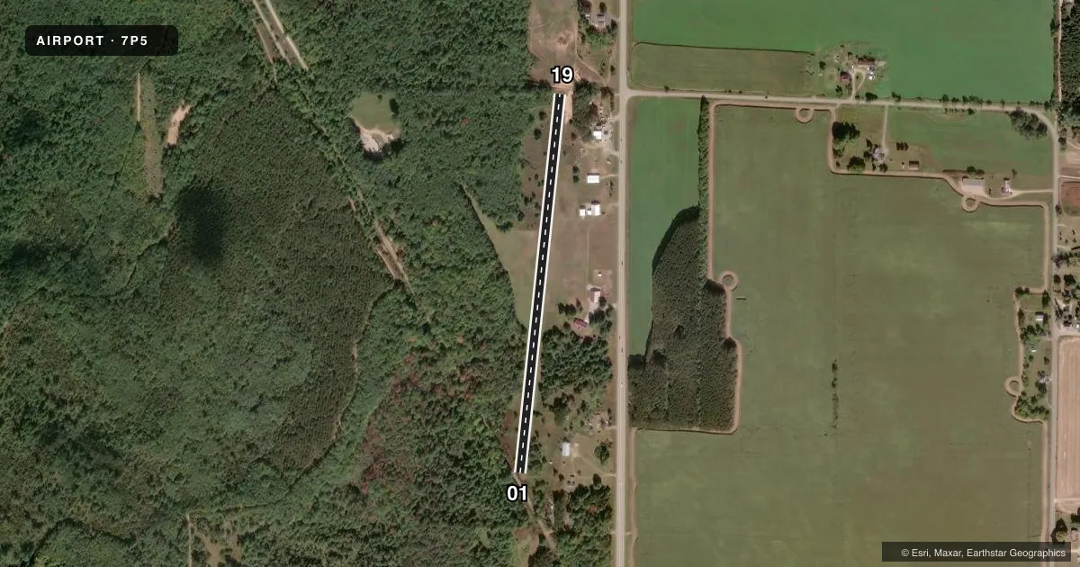
Airport sketch
Runways drawn to scale from FAA survey coordinates, rendered over satellite imagery. Not for navigation.
Approaches & charts
Services on the field
Fuel grades, oxygen, maintenance, ramp storage and lighting — as declared to the FAA by the airport operator.
Fuel & services
- Fuel
- MOGAS
Ramp & ground
- Transient storage
- Tie-down
- Landing fee
- No fee published
- Customs
- Not available
- Wind indicator
- Yes
- Segmented circle
- No
Fuel & FBOs
Cheapest 100LL and Jet A on the field and nearby. Always confirm with the FBO before taxi.
Airport notes
Surface conditions, obstructions, local procedures, lighting outages and other notes published with each FAA cycle.
General notes
- WINTER MAINT NA: OPN TO SKI EQUIP ACFT & HEL.
- FOR CD CTC MINNEAPOLIS ARTCC AT 651-463-5588.
- ULTRALIGHT OPS & WILDLIFE ON & INVOF ARPT.
Fuel notes
- MOGASSELF SVC H24 WITH CREDIT CARD; N END.
Approach & departure obstructions
- 01WHITE CONES.
- 19WHITE CONES.
- 01ORANGE BARRELS.
- 19ORANGE BARRELS.
- 01CTL OBSTN EXCEEDS A 45 DEG SLOPE.
Other notes
- ORANGE FLAGS.
VFR map & nearby airports
VFR sectional. Tap any ICAO chip to open that airport.
Key facts · 7P5
Answer card- ICAO
- 7P5
- Name
- PISO
- Location
- SURING, WISCONSIN
- Elevation
- 895 ft MSL
- Traffic pattern altitude
- 1,395 ft MSL (500 AGL)
- Control tower
- Non-towered (use CTAF)
- Total runways
- 1
- Longest runway
- 01/19 · 2,340 ft
- Published ILS approaches
- 0
- Published frequencies
- 1
- Magnetic variation
- 1°
- Current flight rules
- VFR
- Current wind
- 000° at 0 kt
- Favored runway now
- –
PISO Airport sits near Suring, Wisconsin. Field elevation is 895 ft MSL. It has one runway. The longest is 01/19 at 2,340 ft on turf. There is no control tower. CTAF is 122.9. No ILS approaches are published here. Pattern altitude is 500 ft AGL, which is 1,395 ft MSL.
Piso Airport is the on-field FBO. It carries MOGAS. Self-service mogas is available 24 hours with credit card at the north end. If you need clearance delivery, contact Minneapolis ARTCC at 651-463-5588. The published remarks also note that winter maintenance is not available. The field is open to ski-equipped aircraft and helicopters.
A first-time pilot should pay close attention to the runway markings. White cones mark the displaced threshold on runway 01. Orange barrels mark runway 01. White cones also mark the displaced threshold on runway 19. Orange barrels mark runway 19. There is also a central obstruction near runway 01 that exceeds a 45 degree slope. Ultralight operations and wildlife are on and in the vicinity of the airport. That makes a careful low approach and a good pre-landing scan important. With a turf runway and no tower, plan ahead and verify current field conditions before you go.