METAR & TAF 3D1
3D1 does not publish a METAR.
Showing the nearest reporting station: KMNM (MENOMINEE RGNL) · 19.1 NM away. Conditions at 3D1 may differ.
METAR · KMNM
Observed 12:57Z
KMNM 271257Z AUTO 30003KT 10SM CLR 25/18 A2975 RMK AO2 TSE05RAB12E24 SLP066 P0000 T02500183 $
- Wind
- 300° @ 3 kt
- Visibility
- 10 SM
- Temp / Dew
- 25°C / 18°C
- Altimeter
- 29.75 inHg
- Clouds
- CLR
- Density alt
- 2,322 ft
- Ceiling
- Unlimited
- Rules
- VFR
Airport info & contacts
Manager on record, flight service, ARTCC, attendance schedule and pattern altitude — published by the FAA and refreshed every 28 days.
Location
- From city
- 3 NM SW
- VFR sectional
- GREEN BAY
- ARTCC
- ZMP · MINNEAPOLIS
- NOTAM facility
- GRB (NOTAM-D)
Airport manager
- Name
- JIM STRADAL
- Phone
- (715) 927-2793
- Address
- W9484 COUNTY ROAD X, CRIVITZ WI 54114
Flight service · Hours
- FSS GRB
- GREEN BAY1-800-WX-BRIEF
- Attendance
- Unattended
Frequencies
Tap any row to copy the frequency to your clipboard.
Runways & pattern
Full pagePattern entry · RWY 27
LEFT TRAFFIC| Runway | Heading (°M) | Length | Surface | Traffic |
|---|---|---|---|---|
| 09/27Favored | 90° / 270° | 2,545 ft | TURF | Standard L |
| 18/36 | 179° / 359° | 2,164 ft | ASPH | Standard L |
Runway end performance
| End | TORA | TODA | ASDA | LDA | VGSI | Approach lights | Obstruction |
|---|---|---|---|---|---|---|---|
| 09 | — | — | — | — | — | — | 25', pline, 20' from thr, 0' R of cntrln, slope 1 |
| 27 | — | — | — | — | — | — | 30', trees, 50' from thr, 100' R of cntrln, slope 1 |
| 18 | — | — | — | — | — | — | 16', road, 200' from thr, 0' R of cntrln, slope 0 |
| 36 | — | — | — | — | — | — | 16', road, 210' from thr, 0' R of cntrln, slope 0 |
Declared distances in feet. TORA = takeoff run available, TODA = takeoff distance, ASDA = accelerate-stop, LDA = landing distance.
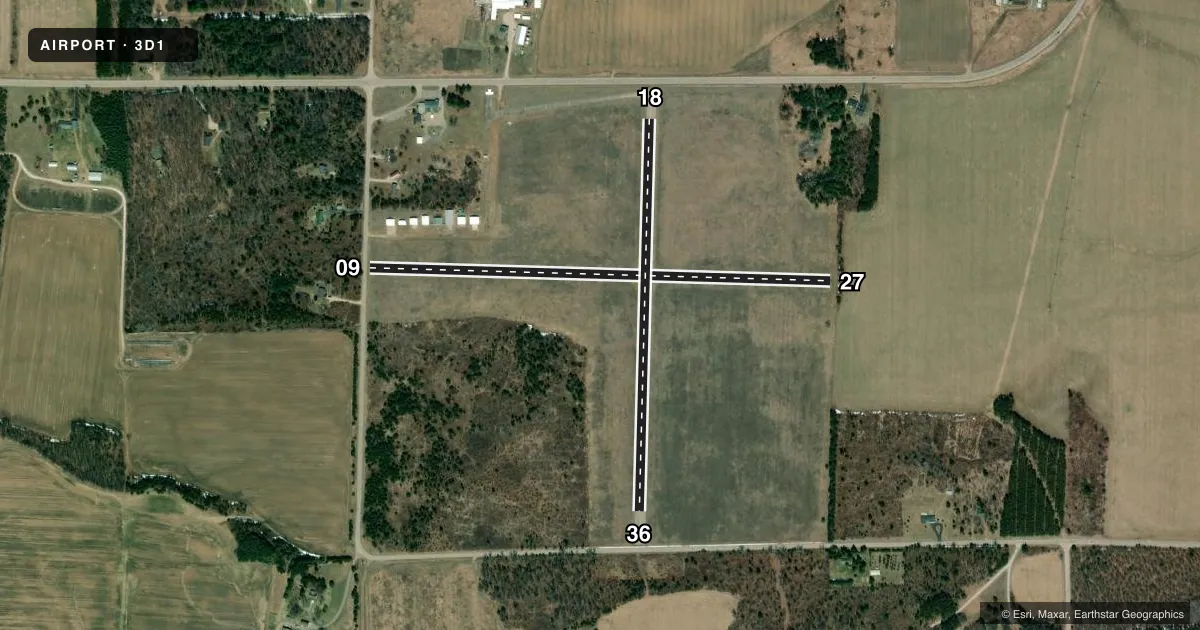
Airport sketch
Runways drawn to scale from FAA survey coordinates, rendered over satellite imagery. Not for navigation.
Approaches & charts
Services on the field
Fuel grades, oxygen, maintenance, ramp storage and lighting — as declared to the FAA by the airport operator.
Fuel & services
- Fuel
- Not available
- Oxygen (bottled)
- Not available
- Oxygen (bulk)
- Not available
- Airframe repair
- Not available
- Power plant repair
- Not available
Ramp & ground
- Transient storage
- Tie-down
- Landing fee
- No fee published
- Customs
- Not available
- Lighting schedule
- SEE RMK
- Beacon schedule
- SEE RMK
- Beacon
- White / Green (civil land)(WG)
- Wind indicator
- Yes
- Segmented circle
- Yes
Fuel & FBOs
Cheapest 100LL and Jet A on the field and nearby. Always confirm with the FBO before taxi.
Airport notes
Surface conditions, obstructions, local procedures, lighting outages and other notes published with each FAA cycle.
General notes
- DEER ON & INVOF ARPT.
- FOR CD CTC MINNEAPOLIS ARTCC AT 651-463-5588.
Lighting notes
- ROTG BCN - 5 CLICKS ON 123.0.
- ACTVT LIRL RWY 18/36 - 123.0.
Runway surface & condition
- 09/27NOT PLOWED WINTER MONTHS.
- 18/36TO CONFIRM SNOW REMOVAL CTC AMGR.
Approach & departure obstructions
- 183 FT BERM AT RWY END.
- 363 FT BERM AT RWY END.
- 09MKD WITH YELLOW CONES.
- 27MKD WITH YELLOW CONES.
- 09APCH RATIO 20:1 TO DSPLCD THR.
- 18APCH RATIO 20:1 TO DSPLCD THR.
- 27APCH RATIO 6:1 TO DSPLCD THR; 30 FT TREES 188 FT FM DSPLCD THR, 100 FT R.
- 36APCH RATIO 16:1 TO DSPLCD THR; 33 FT TREES 530 FT FM DSPLCD THR 75 FT R.
Other notes
- PRIOR TO 1959.
VFR map & nearby airports
VFR sectional. Tap any ICAO chip to open that airport.
Key facts · 3D1
Answer card- ICAO
- 3D1
- Name
- CRIVITZ MUNI
- Location
- CRIVITZ, WISCONSIN
- Elevation
- 734.8 ft MSL
- Traffic pattern altitude
- 1,734.8 ft MSL (1,000 AGL)
- Control tower
- Non-towered (use CTAF)
- Total runways
- 2
- Longest runway
- 09/27 · 2,545 ft
- Published ILS approaches
- 0
- Published frequencies
- 2
- Magnetic variation
- 2°
- Current flight rules
- VFR
- Current wind
- 300° at 3 kt
- Favored runway now
- RWY 27
Crivitz Muni sits in Crivitz, Wisconsin at 734.8 ft MSL. It has two runways. The longest is runway 09/27 at 2,545 ft. This is an untowered field, so use CTAF 122.8 for local traffic and runway calls. No ILS approaches are published here.
Pattern altitude is not published. Use 1,000 ft AGL for light piston operations unless the current Chart Supplement says otherwise. Runway 09/27 is turf. Runway 18/36 is asphalt. The published remarks matter here. Runway 09/27 is not plowed in winter. Runway 27 has yellow cones. The beacon uses 5 clicks on 123.0. Low intensity runway lights on 18/36 also activate with 123.0.
There are no on-field FBOs listed in the facts. Plan on calling the airport operator or the field directly before arrival if you need fuel, tie-down details, or snow removal status. The remarks also note terrain and obstacle issues on all four runway ends. Trees sit near the displaced thresholds on 27 and 36. Runway 18 has a 3-foot berm at the end. Runway 36 also has a 3-foot berm. For clearance delivery, Minneapolis ARTCC is listed at 651-463-5588. Check the current Chart Supplement before you go.