METAR & TAF 3D2
Current METAR
Observed 13:35Z
K3D2 271335Z AUTO 26003KT 10SM CLR 24/17 A2974 RMK AO2 T02380167
- Wind
- 260° @ 3 kt
- Visibility
- 10 SM
- Temp / Dew
- 24°C / 17°C
- Altimeter
- 29.74 inHg
- Clouds
- CLR
- Density alt
- 2,262 ft
- Ceiling
- Unlimited
- Rules
- VFR
Airport info & contacts
Manager on record, flight service, ARTCC, attendance schedule and pattern altitude — published by the FAA and refreshed every 28 days.
Location
- From city
- 1 NM SW
- VFR sectional
- GREEN BAY
- ARTCC
- ZMP · MINNEAPOLIS
- NOTAM facility
- GRB (NOTAM-D)
Airport manager
- Name
- TRAVIS THYSSEN
- Phone
- 920-868-1714
- Address
- P O BOX 850, FISH CREEK WI 54212
Flight service · Hours
- FSS GRB
- GREEN BAY1-800-WX-BRIEF
- Attendance
- JUN-OCT · SAT-SUN · 1000-1700
- JUN-OCT · FRI · 1500-1800
Frequencies
Tap any row to copy the frequency to your clipboard.
Runways & pattern
Full pagePattern entry · RWY 32
LEFT TRAFFIC| Runway | Heading (°M) | Length | Surface | Traffic |
|---|---|---|---|---|
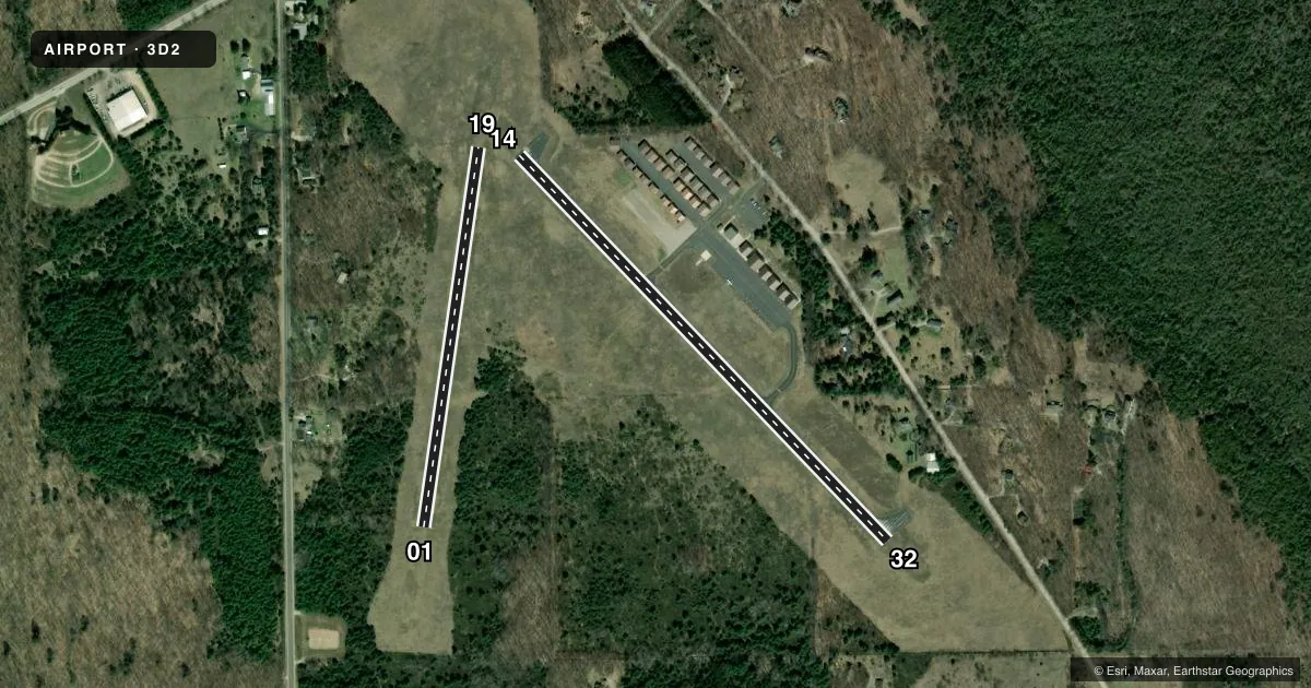
| 14/32Favored | 132° / 312° | 2,697 ft | ASPH | Standard L |
| 01/19 | 4° / 184° | 1,941 ft | TURF | Standard L |
Runway end performance
| End | TORA | TODA | ASDA | LDA | VGSI | Approach lights | Obstruction |
|---|---|---|---|---|---|---|---|
| 14 | — | — | — | — | PAPI 2-box left(3.5°) | — | — |
| 32 | — | — | — | — | PAPI 2-box left(3°) | — | — |
Declared distances in feet. TORA = takeoff run available, TODA = takeoff distance, ASDA = accelerate-stop, LDA = landing distance.
Airport sketch
Runways drawn to scale from FAA survey coordinates, rendered over satellite imagery. Not for navigation.
Approaches & charts
Services on the field
Fuel grades, oxygen, maintenance, ramp storage and lighting — as declared to the FAA by the airport operator.
Fuel & services
- Fuel
- 100LL
- Oxygen (bottled)
- Not available
- Oxygen (bulk)
- Not available
- Airframe repair
- Not available
- Power plant repair
- Not available
Ramp & ground
- Transient storage
- Tie-down
- Landing fee
- No fee published
- Customs
- Not available
- Lighting schedule
- SEE RMK
- Beacon schedule
- SS-SR
- Beacon
- White / Green (civil land)(WG)
- Wind indicator
- Lighted
- Segmented circle
- Yes
Fuel & FBOs
Cheapest 100LL and Jet A on the field and nearby. Always confirm with the FBO before taxi.
Airport notes
Surface conditions, obstructions, local procedures, lighting outages and other notes published with each FAA cycle.
General notes
- DEER NR MOVEMENT AREAS.
- FOR CD CTC GREEN BAY APCH AT 920-431-5741, WHEN GREEN BAY APCH CLSD, FOR CD CTC MINNEAPOLIS ARTCC AT 651-463-5588.
Lighting notes
- MIRL RWY 14/32 PRESET LOW SS-SR; INCR INTST AND ACTVT PAPI RWY 14 & 32; MIRL RWY 14/32 - CTAF.
Fuel notes
- 100LL24 HR SELF SVC FUEL AVBL WITH CREDIT CARD.
Approach & departure obstructions
- 01MKD WITH YELLOW CONES.
- 19MKD WITH YELLOW CONES.
Other notes
- OWNER& TOWN OF GIBRALTAR.
- MANAGERARPT OFC PHONE NR 920-854-3312, AVBL JUN-OCT, FRI-SUN.
- 01/19SLOPES MDTELY DOWN TO SOUTH--CANNOT SEE ONE END FM THE OTHER.
VFR map & nearby airports
VFR sectional. Tap any ICAO chip to open that airport.
Key facts · 3D2
Answer card- ICAO
- 3D2
- Name
- EPHRAIM/GIBRALTAR
- Location
- EPHRAIM, WISCONSIN
- Elevation
- 773.1 ft MSL
- Traffic pattern altitude
- 1,773.1 ft MSL (1,000 AGL)
- Control tower
- Non-towered (use CTAF)
- Total runways
- 2
- Longest runway
- 14/32 · 2,697 ft
- Published ILS approaches
- 0
- Published frequencies
- 4
- Magnetic variation
- 4°
- Current flight rules
- VFR
- Current wind
- 260° at 3 kt
- Favored runway now
- RWY 32
Ephraim/Gibraltar Airport sits in Ephraim, Wisconsin. Field elevation is 773.1 ft MSL. The airport has 2 runways. The longest is runway 14/32 at 2,697 ft. There is no control tower. Pattern altitude is not published. Use the standard 1,000 ft AGL pattern for light piston traffic unless local conditions or current guidance say otherwise.
No ILS approaches are published here. CTAF and UNICOM are both 123.0. Green Bay Approach handles the approach and departure frequencies listed for the field. For clearance delivery, contact Green Bay Approach. If that facility is closed, use Minneapolis ARTCC.
The on-field FBO is Ephraim-Gibraltar Airport. It carries 100LL. 24-hour self-serve fuel is available with credit card. The airport office phone number is 920-854-3312. The office is available June through October, Friday through Sunday.
A few local items matter on the ground. Runway 01/19 is turf. It slopes moderately down to the south. You cannot see one end from the other. Runway 01 and runway 19 are both marked with yellow cones. Deer near the movement areas are also published, so keep your scan active on taxi and final. Runway 14/32 has medium intensity lights that are controlled by CTAF. They are preset low from sunset to sunrise. This is a non-towered field, so plan your self-announce calls and verify current airport details before departure.