METAR & TAF KESC
Current METAR
Observed 15:56Z
KESC 271556Z AUTO 13007KT 7SM FEW030 SCT095 22/ A2965 RMK AO2 LTG DSNT S AND SW RAE54 SLP041 P0005 T0217
- Wind
- 130° @ 7 kt
- Visibility
- 7 SM
- Temp / Dew
- —
- Altimeter
- 29.65 inHg
- Clouds
- SCT
- Density alt
- —
- Ceiling
- Unlimited
- Rules
- VFR
Airport info & contacts
Manager on record, flight service, ARTCC, attendance schedule and pattern altitude — published by the FAA and refreshed every 28 days.
Location
- From city
- 2 NM SW
- VFR sectional
- GREEN BAY
- ARTCC
- ZMP · MINNEAPOLIS
- NOTAM facility
- ESC (NOTAM-D)
Airport manager
- Name
- ASHLEIGH YOUNG
- Phone
- 906-789-5100
- Address
- DELTA COUNTY AIRPORT, 3300 AIRPORT RD, ESCANABA MI 49829-1057
Flight service · Hours
- FSS GRB
- GREEN BAY1-800-WX-BRIEF
- Attendance
- 0600-2130
Frequencies
Tap any row to copy the frequency to your clipboard.
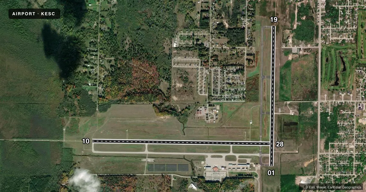
Runways & pattern
Full pagePattern entry · RWY 10
LEFT TRAFFIC| Runway | Heading (°M) | Length | Surface | Traffic |
|---|---|---|---|---|
| 10/28Favored | 86° / 266° | 6,498 ft | ASPH | Standard L |
| 01/19 | 356° / 176° | 5,016 ft | ASPH | Standard L |
Runway end performance
| End | TORA | TODA | ASDA | LDA | VGSI | Approach lights | Obstruction |
|---|---|---|---|---|---|---|---|
| 10 | 6,498' | 6,498' | 6,498' | 6,498' | — | MALSR | — |
| 28 | 6,498' | 6,498' | 6,498' | 6,498' | PAPI 4-box right(3°) | — | — |
| 01 | 5,015' | 5,015' | 5,015' | 5,015' | PAPI 4-box left(3°) | — | 51', tree, 1871' from thr, 61' R of cntrln, slope 31 |
| 19 | 5,015' | 5,015' | 5,015' | 5,015' | PAPI 4-box left(3°) | — | — |
Declared distances in feet. TORA = takeoff run available, TODA = takeoff distance, ASDA = accelerate-stop, LDA = landing distance.
Airport sketch
Runways drawn to scale from FAA survey coordinates, rendered over satellite imagery. Not for navigation.
Approaches & charts
ILS · 1
Services on the field
Fuel grades, oxygen, maintenance, ramp storage and lighting — as declared to the FAA by the airport operator.
Fuel & services
- Fuel
- 100LLA
- Oxygen (bottled)
- Not available
- Oxygen (bulk)
- Not available
- Airframe repair
- Not available
- Power plant repair
- Not available
- Other services
- AFRT,CARGO,INSTR,RNTL
Ramp & ground
- Transient storage
- Tie-down
- Hangar
- Landing fee
- No fee published
- Customs
- Not available
- Lighting schedule
- SEE RMK
- Beacon schedule
- SS-SR
- Beacon
- White / Green (civil land)(WG)
- Wind indicator
- Lighted
- Segmented circle
- Yes
Fuel & FBOs
Cheapest 100LL and Jet A on the field and nearby. Always confirm with the FBO before taxi.
Airport notes
Surface conditions, obstructions, local procedures, lighting outages and other notes published with each FAA cycle.
General notes
- FLD CONDS UNMON 2130-0600.
- FOR CD IF UNA TO CTC ON FSS FREQ, CTC MINNEAPOLIS ARTCC AT 651-463-5588.
- BIRDS ON & INVOF ARPT.
Lighting notes
- ACTVT MALSR RWY 10; REIL RWY 01 & 28; PAPI RWY 28, 01, & 19; HIRL RWY 10/28; MIRL RWY 01/19 - CTAF.
Fuel notes
- 100LL100LL AVBL H24 SELF SVC.
Runway surface & condition
- 01/19PCR VALUE: 280/F/C/X/U
- 10/28PCR VALUE: 460/F/C/X/U
Other notes
- COML/CHTR ACFT SUBJ LDG FEE - CALL FOR RATES.
- ALL ACFT SUBJ OVNGT PRKG FEE - CALL FOR RATES.
- 1FOR SVC CALL ARPT OPS 906-420-1591.
VFR map & nearby airports
VFR sectional. Tap any ICAO chip to open that airport.
Key facts · KESC
Answer card- ICAO
- KESC
- Name
- DELTA COUNTY
- Location
- ESCANABA, MICHIGAN
- Elevation
- 609.1 ft MSL
- Traffic pattern altitude
- 1,609.1 ft MSL (1,000 AGL)
- Control tower
- Non-towered (use CTAF)
- Total runways
- 2
- Longest runway
- 10/28 · 6,498 ft
- Published ILS approaches
- 1
- Published frequencies
- 2
- Magnetic variation
- 5°
- Current flight rules
- VFR
- Current wind
- 130° at 7 kt
- Favored runway now
- RWY 10
Delta County Airport sits in Escanaba, Michigan. Field elevation is 609.1 ft MSL. The airport has two asphalt runways. The longest is runway 10/28 at 6,498 ft. This is an uncontrolled field. CTAF and UNICOM are both 122.8. The published ILS is on runway 10. Pattern altitude is not published, so use the standard 1,000 ft AGL for light piston traffic unless ATC or the Chart Supplement says otherwise.
The on-field FBO is Delta County Airport. It carries 100LL, Jet A and Jet A Prist. 100LL is available 24 hours a day by self-serve. Birds are reported on and near the airport, so keep a sharp scan on arrival and departure. Field conditions are unmonitored from 2130 to 0600. Lighting is good for night work on the main runway. Runway 10 has MALSR and high intensity lights. Runway 01 and 28 have runway end identifier lights. PAPI is published for runways 28, 01 and 19. If you need service, airport operations can be reached at 906-420-1591. Commercial and charter traffic should plan for landing fees. All aircraft are subject to overnight parking fees. Check the current FAA Chart Supplement for any current operational notes before you go.