METAR & TAF 2P2
Current METAR
Observed 13:35Z
K2P2 271335Z AUTO 27005KT 10SM SCT100 23/21 A2974 RMK AO2 LTG DSNT N T02310209
- Wind
- 270° @ 5 kt
- Visibility
- 10 SM
- Temp / Dew
- 23°C / 21°C
- Altimeter
- 29.74 inHg
- Clouds
- SCT
- Density alt
- 1,992 ft
- Ceiling
- Unlimited
- Rules
- VFR
Airport info & contacts
Manager on record, flight service, ARTCC, attendance schedule and pattern altitude — published by the FAA and refreshed every 28 days.
Location
- From city
- 1 NM S
- VFR sectional
- GREEN BAY
- ARTCC
- ZMP · MINNEAPOLIS
- NOTAM facility
- GRB (NOTAM-D)
Airport manager
- Name
- RICHARD DONNELLY
- Phone
- (920) 535-0546
- Address
- PO BOX 220, WASHINGTON ISLAND WI 54246
Flight service · Hours
- FSS GRB
- GREEN BAY1-800-WX-BRIEF
- Attendance
- Unattended
Frequencies
Tap any row to copy the frequency to your clipboard.
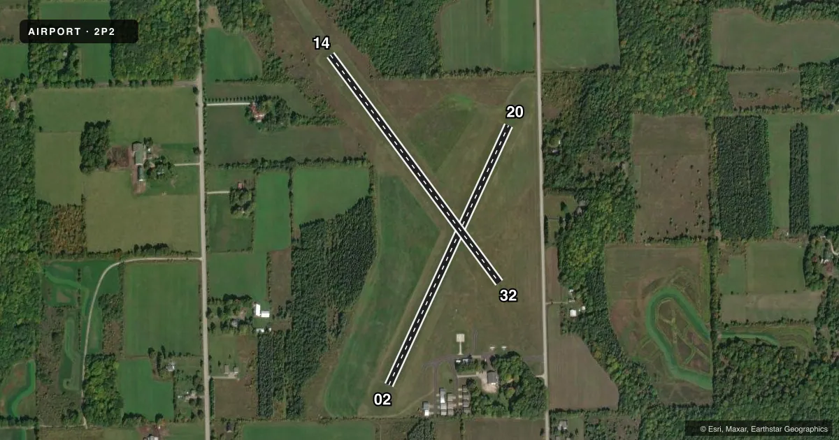
Runways & pattern
Full pagePattern entry · RWY 32
LEFT TRAFFIC| Runway | Heading (°M) | Length | Surface | Traffic |
|---|---|---|---|---|
| 02/20 | 21° / 201° | 2,250 ft | TURF | Standard L |
| 14/32Favored | 139° / 319° | 2,232 ft | TURF | Standard L |
Runway end performance
| End | TORA | TODA | ASDA | LDA | VGSI | Approach lights | Obstruction |
|---|---|---|---|---|---|---|---|
| 02 | — | — | — | — | — | — | 45', trees, 750' from thr, 200' R of cntrln, slope 16 |
| 20 | — | — | — | — | — | — | 32', trees, 380' from thr, 140' R of cntrln, slope 11 |
| 14 | — | — | — | — | — | — | 66', trees, 690' from thr, 190' R of cntrln, slope 10 |
| 32 | — | — | — | — | — | — | 61', tree, 590' from thr, 180' R of cntrln, slope 9 |
Declared distances in feet. TORA = takeoff run available, TODA = takeoff distance, ASDA = accelerate-stop, LDA = landing distance.
Airport sketch
Runways drawn to scale from FAA survey coordinates, rendered over satellite imagery. Not for navigation.
Approaches & charts
Services on the field
Fuel grades, oxygen, maintenance, ramp storage and lighting — as declared to the FAA by the airport operator.
Fuel & services
- Fuel
- Not available
- Oxygen (bottled)
- Not available
- Oxygen (bulk)
- Not available
- Airframe repair
- Not available
- Power plant repair
- Not available
Ramp & ground
- Transient storage
- Tie-down
- Landing fee
- No fee published
- Customs
- Not available
- Lighting schedule
- SEE RMK
- Beacon schedule
- SEE RMK
- Beacon
- White / Green (civil land)(WG)
- Wind indicator
- Lighted
- Segmented circle
- No
Fuel & FBOs
Cheapest 100LL and Jet A on the field and nearby. Always confirm with the FBO before taxi.
Airport notes
Surface conditions, obstructions, local procedures, lighting outages and other notes published with each FAA cycle.
General notes
- RY 14/32 +12' RISE IN RY ELEV NW 900 FT.
- NUMEROUS FLOCKS OF WATERFOWL & DEER ON & INVOF ARPT.
- RWY 02/20 & RWY 14/32 PLWD WHEN SNOW IS OVER 3 INCHES. CFM CONDS 920-535-0979.
- FOR CD CTC MINNEAPOLIS ARTCC AT 651-463-5588.
Lighting notes
- ACTVT ROTG BCN - CTAF.
- LIRL RWY 02/20 OPR SS-SS AND PRESET TO LOW INTST; TO INCR INTST AND ACTVT LIRL RWY 02/20 & 14/32 - CTAF.
Approach & departure obstructions
- 02MKD WITH YELLOW CONES.
- 14MKD WITH YELLOW CONES.
- 20MKD WITH YELLOW CONES.
- 32MKD WITH YELLOW CONES.
Other notes
- ESTABLISHED PRIOR TO 1959
- ACTVT WIND SOCK/WIND TEE - CTAF.
- MANAGEREMAIL ADDRESS: TOWNAIRPORT@WASHINGTONISLAND-WI.GOV (ALL LOWER CASE)
- MANAGERARPT PHONE 920-847-2448.
VFR map & nearby airports
VFR sectional. Tap any ICAO chip to open that airport.
Key facts · 2P2
Answer card- ICAO
- 2P2
- Name
- WASHINGTON ISLAND
- Location
- WASHINGTON ISLAND, WISCONSIN
- Elevation
- 652.5 ft MSL
- Traffic pattern altitude
- 1,652.5 ft MSL (1,000 AGL)
- Control tower
- Non-towered (use CTAF)
- Total runways
- 2
- Longest runway
- 02/20 · 2,250 ft
- Published ILS approaches
- 0
- Published frequencies
- 1
- Magnetic variation
- 4°
- Current flight rules
- VFR
- Current wind
- 270° at 5 kt
- Favored runway now
- RWY 32
Washington Island Airport (2P2) sits on Washington Island in Wisconsin. Field elevation is 652.5 ft MSL. The airport has 2 turf runways. The longest is runway 02/20 at 2,250 ft. Runway 14/32 is 2,232 ft. There is no control tower. CTAF is 122.9.
No ILS approaches are published here. Pattern altitude is not published, so use the standard 1,000 ft AGL unless the current Chart Supplement says otherwise. That puts the light piston pattern at about 1,652.5 ft MSL based on the listed field elevation. Runway 02/20 has low intensity lights that run from sunset to sunrise. The lights are preset to low intensity. Use the CTAF to increase intensity and to activate the lights on both runways. A rotating beacon is also available on the CTAF.
There are no on-field FBOs listed. Plan on confirming services with the airport operator before you go. Published remarks also note yellow cones on runway 32 and on runway 14. Runway 14/32 has a 12 ft rise in runway elevation in the northwest 900 ft. Watch for waterfowl and deer on and near the airport. For clearance delivery, contact Minneapolis ARTCC. This is a small non-towered turf field, so a careful CTAF scan and a short-field mindset make sense.