METAR & TAF 6Y4
6Y4 does not publish a METAR.
Showing the nearest reporting station: KSAW (MARQUETTE/SAWYER RGNL) · 18.7 NM away. Conditions at 6Y4 may differ.
METAR · KSAW
Observed 06:38Z
KSAW 270638Z AUTO 28003KT 10SM CLR 22/20 A2973 RMK AO2 LTG DSNT SW
- Wind
- 280° @ 3 kt
- Visibility
- 10 SM
- Temp / Dew
- 22°C / 20°C
- Altimeter
- 29.73 inHg
- Clouds
- CLR
- Density alt
- 2,278 ft
- Ceiling
- Unlimited
- Rules
- VFR
Airport info & contacts
Manager on record, flight service, ARTCC, attendance schedule and pattern altitude — published by the FAA and refreshed every 28 days.
Location
- From city
- 4 NM SW
- VFR sectional
- GREEN BAY
- ARTCC
- ZMP · MINNEAPOLIS
- NOTAM facility
- GRB (NOTAM-D)
Airport manager
- Name
- JASON M VAN EFFEN
- Phone
- 906-869-7623
- Address
- 2310 HOLLY 35.5 RD, ROCK MI 49880-9435
Flight service · Hours
- FSS GRB
- GREEN BAY1-800-WX-BRIEF
- Attendance
- Unattended
Frequencies
Tap any row to copy the frequency to your clipboard.
Runways & pattern
Full pagePattern entry · RWY 30
LEFT TRAFFICRunway end performance
| End | TORA | TODA | ASDA | LDA | VGSI | Approach lights | Obstruction |
|---|---|---|---|---|---|---|---|
| 12 | — | — | — | — | — | — | 15', road, 50' from thr, 125' R of cntrln, slope 3 |
| 30 | — | — | — | — | — | — | 73', trees, 220' from thr, slope 3 |
Declared distances in feet. TORA = takeoff run available, TODA = takeoff distance, ASDA = accelerate-stop, LDA = landing distance.
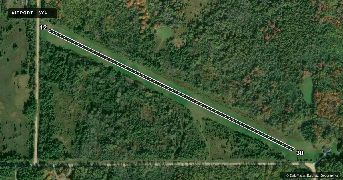
Airport sketch
Runways drawn to scale from FAA survey coordinates, rendered over satellite imagery. Not for navigation.
Approaches & charts
Services on the field
Fuel grades, oxygen, maintenance, ramp storage and lighting — as declared to the FAA by the airport operator.
Fuel & services
- Fuel
- Not available
Ramp & ground
- Transient storage
- Not published
- Wind indicator
- Yes
Fuel & FBOs
Cheapest 100LL and Jet A on the field and nearby. Always confirm with the FBO before taxi.
Airport notes
Surface conditions, obstructions, local procedures, lighting outages and other notes published with each FAA cycle.
General notes
- NO SNOW REMOVAL.
- FOR CD CTC MINNEAPOLIS ARTCC AT 651-463-5588.
- DEER, BIRDS & WILDLIFE ON INVOF RWY.
Approach & departure obstructions
- 12RWY 12 DTHR MKD WITH YELLOW CONES.
- 30RWY 30 DTHR MKD WITH YELLOW CONES.
- 12RWY 12 APCH RATIO 20:1 TO DTHR.
- 30RWY 30 APCH RATIO 20:1 TO DTHR.
Other notes
- OWNERCELL.
VFR map & nearby airports
VFR sectional. Tap any ICAO chip to open that airport.
Key facts · 6Y4
Answer card- ICAO
- 6Y4
- Name
- VAN EFFEN FLD
- Location
- ROCK, MICHIGAN
- Elevation
- 970 ft MSL
- Traffic pattern altitude
- 1,970 ft MSL (1,000 AGL)
- Control tower
- Non-towered (use CTAF)
- Total runways
- 1
- Longest runway
- 12/30 · 2,600 ft
- Published ILS approaches
- 0
- Published frequencies
- 1
- Magnetic variation
- –
- Current flight rules
- VFR
- Current wind
- 280° at 3 kt
- Favored runway now
- RWY 30
Van Effen Fld sits in Rock, Michigan. The field elevation is 970 ft MSL. It has one runway, 12/30, which is 2,600 ft of turf. There is no control tower. CTAF is 122.9. No ILS approaches are published here.
The published pattern altitude is not listed. Use the standard 1,000 ft AGL pattern unless the current Chart Supplement says otherwise. Runway 12 and Runway 30 both have displaced thresholds marked with yellow cones. Both approaches also carry a 20 to 1 obstacle clearance slope to the displaced threshold. That makes a stabilized approach important, especially on a short turf strip.
There are no on-field FBOs listed. Contact the airport operator directly before arrival if you need local services. Published remarks also note deer, birds and other wildlife near the runway. There is no snow removal at this airport. For clearance delivery, contact Minneapolis ARTCC at 651-463-5588. Pilots planning a first visit should review the current Chart Supplement for any updated local procedures. Then brief the turf surface, the displaced thresholds and the wildlife risk before departure.