METAR & TAF 5Y7
5Y7 does not publish a METAR.
Showing the nearest reporting station: KISQ (SCHOOLCRAFT COUNTY) · 29.5 NM away. Conditions at 5Y7 may differ.
METAR · KISQ
Observed 15:55Z
KISQ 271555Z AUTO 21008KT 7SM SCT050 SCT070 SCT120 21/20 A2970 RMK AO2 PRESFR
- Wind
- 210° @ 8 kt
- Visibility
- 7 SM
- Temp / Dew
- 21°C / 20°C
- Altimeter
- 29.70 inHg
- Clouds
- SCT
- Density alt
- 2,213 ft
- Ceiling
- Unlimited
- Rules
- VFR
Airport info & contacts
Manager on record, flight service, ARTCC, attendance schedule and pattern altitude — published by the FAA and refreshed every 28 days.
Location
- From city
- 3 NM SE
- VFR sectional
- GREEN BAY
- ARTCC
- ZMP · MINNEAPOLIS
- NOTAM facility
- GRB (NOTAM-D)
Airport manager
- Name
- DICK BOWERMAN
- Phone
- 906-387-4686
- Address
- 101 COURT ST, MUNISING MI 49862-1196
Flight service · Hours
- FSS GRB
- GREEN BAY1-800-WX-BRIEF
- Attendance
- Unattended
Frequencies
Tap any row to copy the frequency to your clipboard.
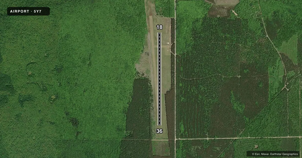
Runways & pattern
Full pagePattern entry · RWY 18
LEFT TRAFFICAirport sketch
Runways drawn to scale from FAA survey coordinates, rendered over satellite imagery. Not for navigation.
Approaches & charts
Services on the field
Fuel grades, oxygen, maintenance, ramp storage and lighting — as declared to the FAA by the airport operator.
Fuel & services
- Fuel
- Not available
- Oxygen (bottled)
- Not available
- Oxygen (bulk)
- Not available
- Airframe repair
- Not available
- Power plant repair
- Not available
Ramp & ground
- Transient storage
- Tie-down
- Landing fee
- No fee published
- Customs
- Not available
- Wind indicator
- Yes
- Segmented circle
- Yes
Fuel & FBOs
Cheapest 100LL and Jet A on the field and nearby. Always confirm with the FBO before taxi.
Airport notes
Surface conditions, obstructions, local procedures, lighting outages and other notes published with each FAA cycle.
General notes
- NO SNOW REMOVAL.
- BIRDS, DEER, & WILDLIFE ON & INVOF ARPT.
- FOR CD CTC MINNEAPOLIS ARTCC AT 651-463-5588.
Approach & departure obstructions
- 1818/36 MKD WITH CONES.
Other notes
- MANAGERCELL 906-202-0818.
VFR map & nearby airports
VFR sectional. Tap any ICAO chip to open that airport.
Key facts · 5Y7
Answer card- ICAO
- 5Y7
- Name
- HANLEY FLD
- Location
- MUNISING, MICHIGAN
- Elevation
- 984 ft MSL
- Traffic pattern altitude
- 1,984 ft MSL (1,000 AGL)
- Control tower
- Non-towered (use CTAF)
- Total runways
- 1
- Longest runway
- 18/36 · 4,000 ft
- Published ILS approaches
- 0
- Published frequencies
- 1
- Magnetic variation
- 4°
- Current flight rules
- VFR
- Current wind
- 210° at 8 kt
- Favored runway now
- RWY 18
Hanley Fld sits in Munising, Michigan. The field elevation is 984 ft MSL. It has one runway. Runway 18/36 is 4,000 ft of turf with magnetic headings of 180° and 0°. The runway is marked with cones. There is no control tower. CTAF is 122.9. No ILS approaches are published here.
Pattern altitude is not published. Use the standard 1,000 ft AGL unless the current FAA Chart Supplement says otherwise. That puts the traffic pattern at 1,984 ft MSL based on the listed field elevation. There is no snow removal, so winter operations need a close look before you launch. Birds, deer and other wildlife are reported on and near the airport. Clearance delivery is handled through Minneapolis ARTCC at 651-463-5588. There are no on-field FBOs listed in the facts. Verify fuel and service availability with the airport operator or on CTAF before you go. Pilots should also check the current Chart Supplement for any local operating notes before arrival.