METAR & TAF 6Y5
6Y5 does not publish a METAR.
Showing the nearest reporting station: KERY (LUCE COUNTY) · 23.0 NM away. Conditions at 6Y5 may differ.
METAR · KERY
Observed 19:35Z
KERY 271935Z AUTO 25005KT 10SM FEW050 SCT055 OVC100 28/19 A2968 RMK AO2
- Wind
- 250° @ 5 kt
- Visibility
- 10 SM
- Temp / Dew
- 28°C / 19°C
- Altimeter
- 29.68 inHg
- Clouds
- OVC
- Density alt
- 2,701 ft
- Ceiling
- 10,000 ft AGL
- Rules
- VFR
Airport info & contacts
Manager on record, flight service, ARTCC, attendance schedule and pattern altitude — published by the FAA and refreshed every 28 days.
Location
- From city
- 20 NM N
- VFR sectional
- GREEN BAY
- ARTCC
- ZMP · MINNEAPOLIS
- NOTAM facility
- GRB (NOTAM-D)
Airport manager
- Name
- GLEN PITTMAN
- Phone
- 906-293-2926
- Address
- 5523 COUNTY ROAD 399, NEWBERRY MI 49868-7882
Flight service · Hours
- FSS GRB
- GREEN BAY1-800-WX-BRIEF
- Attendance
- Unattended
Frequencies
Tap any row to copy the frequency to your clipboard.
Runways & pattern
Full pagePattern entry · RWY 25
LEFT TRAFFICRunway end performance
| End | TORA | TODA | ASDA | LDA | VGSI | Approach lights | Obstruction |
|---|---|---|---|---|---|---|---|
| 07 | — | — | — | — | — | — | 15', road, 0' from thr, 125' R of cntrln, slope 1 |
| 25 | — | — | — | — | — | — | 18', tree, 10' from thr, 65' R of cntrln, slope 0 |
Declared distances in feet. TORA = takeoff run available, TODA = takeoff distance, ASDA = accelerate-stop, LDA = landing distance.
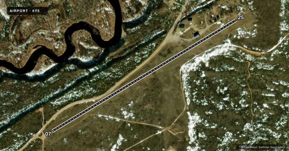
Airport sketch
Runways drawn to scale from FAA survey coordinates, rendered over satellite imagery. Not for navigation.
Approaches & charts
Services on the field
Fuel grades, oxygen, maintenance, ramp storage and lighting — as declared to the FAA by the airport operator.
Fuel & services
- Fuel
- Not available
Ramp & ground
- Transient storage
- Not published
- Wind indicator
- Yes
Fuel & FBOs
Cheapest 100LL and Jet A on the field and nearby. Always confirm with the FBO before taxi.
Airport notes
Surface conditions, obstructions, local procedures, lighting outages and other notes published with each FAA cycle.
General notes
- ARPT CLSD NOV-MAY 15 & WHEN SNOW COVD EXC FOR SKI EQUIPPED ACFT. NO SNOW REMOVAL.
- FQT HIGH WINDS OFF LAKE SUPERIOR.
- FOR CD CTC MINNEAPOLIS ARTCC AT 651-463-5588.
- SAFETY BRIEFING & PILOT INFO AVBL AT THERAF.ORG.
Approach & departure obstructions
- 073 FT YELLOW CONES.
- 253 FT YELLOW CONES.
- 07CTLG OBSTN EXCEEDS A 45 DEG SLP.
Other notes
- MANAGERCELL 906-291-0214.
- OWNERALSO RAINBOW TWO HEART REAL ESTATE HOLDINGS, LLC 906-658-3388.
- 07/25RWY ROUGH & UNEVEN, SOME SOFT AREAS.
- 07/25INTMT PATCHES OF TURF & DIRT.
VFR map & nearby airports
VFR sectional. Tap any ICAO chip to open that airport.
Key facts · 6Y5
Answer card- ICAO
- 6Y5
- Name
- TWO HEARTED AIRSTRIP
- Location
- NEWBERRY, MICHIGAN
- Elevation
- 680 ft MSL
- Traffic pattern altitude
- 1,680 ft MSL (1,000 AGL)
- Control tower
- Non-towered (use CTAF)
- Total runways
- 1
- Longest runway
- 07/25 · 2,400 ft
- Published ILS approaches
- 0
- Published frequencies
- 1
- Magnetic variation
- –
- Current flight rules
- VFR
- Current wind
- 250° at 5 kt
- Favored runway now
- RWY 25
Two Hearted Airstrip sits near Newberry, Michigan. Field elevation is 680 ft MSL. The airport has one runway. Runway 07/25 is 2,400 ft long with a turf-dirt surface. The runway is rough and uneven in spots. Intermittent patches of turf and dirt are present. The published pattern altitude is not listed. Use 1,000 ft AGL for light piston operations unless the current Chart Supplement says otherwise. That puts the pattern at 1,680 ft MSL.
This is an uncontrolled field. CTAF is 122.9. No ILS approaches are published. There are no on-field FBOs listed in the facts. Check with the airport operator or the FBO directly by phone before you go if you need fuel or services. The published remarks also say the airport is closed November through May 15. It is also closed when snow covered except for ski equipped aircraft. No snow removal is provided. Frequent high winds come off Lake Superior, so plan for a gusty arrival and a short-field mindset. The 07 end has a cataloged obstruction that exceeds a 45 degree slope. Three foot yellow cones mark both runway ends. Clearance delivery is handled through Minneapolis ARTCC at 651-463-5588.