METAR & TAF Y98
Y98 does not publish a METAR.
Showing the nearest reporting station: KERY (LUCE COUNTY) · 26.7 NM away. Conditions at Y98 may differ.
METAR · KERY
Observed 18:55Z
KERY 271855Z AUTO VRB02KT 10SM BKN110 29/19 A2967 RMK AO2
- Wind
- VAR @ 2 kt
- Visibility
- 10 SM
- Temp / Dew
- 29°C / 19°C
- Altimeter
- 29.67 inHg
- Clouds
- BKN
- Density alt
- 3,029 ft
- Ceiling
- 11,000 ft AGL
- Rules
- VFR
Airport info & contacts
Manager on record, flight service, ARTCC, attendance schedule and pattern altitude — published by the FAA and refreshed every 28 days.
Location
- From city
- 4 NM SE
- VFR sectional
- GREEN BAY
- ARTCC
- ZMP · MINNEAPOLIS
- NOTAM facility
- GRB (NOTAM-D)
Airport manager
- Name
- HEATHER DOBBERSTEIN
- Phone
- 906-203-7524
- Address
- PO BOX 430, GRAND MARAIS MI 49839-0430
Flight service · Hours
- FSS GRB
- GREEN BAY1-800-WX-BRIEF
- Attendance
- Unattended
Frequencies
Tap any row to copy the frequency to your clipboard.
Runways & pattern
Full pagePattern entry · RWY 32
LEFT TRAFFIC| Runway | Heading (°M) | Length | Surface | Traffic |
|---|---|---|---|---|
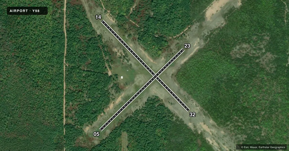
| 14/32Favored | 131° / 311° | 2,800 ft | TURF | Standard L |
| 05/23 | 41° / 221° | 2,600 ft | TURF | Standard L |
Runway end performance
| End | TORA | TODA | ASDA | LDA | VGSI | Approach lights | Obstruction |
|---|---|---|---|---|---|---|---|
| 14 | — | — | — | — | — | — | 15', trees, 130' from thr, 62' R of cntrln, slope 8 |
| 05 | — | — | — | — | — | — | 20', trees, 70' from thr, 127' R of cntrln, slope 3 |
Declared distances in feet. TORA = takeoff run available, TODA = takeoff distance, ASDA = accelerate-stop, LDA = landing distance.
Airport sketch
Runways drawn to scale from FAA survey coordinates, rendered over satellite imagery. Not for navigation.
Approaches & charts
Services on the field
Fuel grades, oxygen, maintenance, ramp storage and lighting — as declared to the FAA by the airport operator.
Fuel & services
- Fuel
- Not available
- Oxygen (bottled)
- Not available
- Oxygen (bulk)
- Not available
- Airframe repair
- Not available
- Power plant repair
- Not available
Ramp & ground
- Transient storage
- Tie-down
- Landing fee
- No fee published
- Wind indicator
- Yes
- Segmented circle
- Yes
Fuel & FBOs
Cheapest 100LL and Jet A on the field and nearby. Always confirm with the FBO before taxi.
Airport notes
Surface conditions, obstructions, local procedures, lighting outages and other notes published with each FAA cycle.
General notes
- ARPT CLSD OCT 15 - MAY 15. RWYS & ROADS TO ARPT NOT PLOWED IN WINTER.
- FOR CD CTC MINNEAPOLIS ARTCC AT 651-463-5588.
Approach & departure obstructions
- 05RWY & DTHR MKD WITH 3 FT YELLOW CONES.
- 143 FT YELLOW CONES.
- 233 FT YELLOW CONES.
- 323 FT YELLOW CONES.
- 05APCH RATIO 20:1 TO DTHR.
Other notes
- MANAGERCELL.
- OWNERTWP HALL.
- 05/23ROUGH.
- 14/32ROUGH WITH AREAS OF SAND.
VFR map & nearby airports
VFR sectional. Tap any ICAO chip to open that airport.
Key facts · Y98
Answer card- ICAO
- Y98
- Name
- GRAND MARAIS
- Location
- GRAND MARAIS, MICHIGAN
- Elevation
- 838 ft MSL
- Traffic pattern altitude
- 1,838 ft MSL (1,000 AGL)
- Control tower
- Non-towered (use CTAF)
- Total runways
- 2
- Longest runway
- 14/32 · 2,800 ft
- Published ILS approaches
- 0
- Published frequencies
- 2
- Magnetic variation
- 5°
- Current flight rules
- VFR
- Current wind
- 000° at 2 kt
- Favored runway now
- RWY 32
Grand Marais Airport (Y98) sits in Grand Marais, Michigan. Field elevation is 838 ft MSL. It has two turf runways. The longest is 2,800 ft on runway 14/32. Runway 05/23 is 2,600 ft. There is no control tower. CTAF and UNICOM are both 122.7. No ILS approaches are published.
The pattern altitude is not published. Use the standard 1,000 ft AGL for light piston operations unless the current Chart Supplement says otherwise. That puts the traffic pattern at 1,838 ft MSL based on the field elevation, but verify the current published guidance before you go. The airport is closed from October 15 to May 15. Runways and roads are not plowed in winter, so plan for seasonal access limits.
The published remarks matter here. Runway 05/23 is rough. Runway 14/32 is rough too, with areas of sand. There are 3-foot yellow cones marking runway areas and displaced threshold items. Runway 05 has a displaced threshold with a 20 to 1 approach ratio. This is a turf field with short runways, so treat it as a soft-field arrival and departure. There are no on-field FBOs listed. Contact the manager by cell phone or the owner at the township hall for current field status. For clearance delivery, contact Minneapolis ARTCC at 651-463-5588.