METAR & TAF KERY
Current METAR
Observed 19:35Z
KERY 271935Z AUTO 25005KT 10SM FEW050 SCT055 OVC100 28/19 A2968 RMK AO2
- Wind
- 250° @ 5 kt
- Visibility
- 10 SM
- Temp / Dew
- 28°C / 19°C
- Altimeter
- 29.68 inHg
- Clouds
- OVC
- Density alt
- 2,935 ft
- Ceiling
- 10,000 ft AGL
- Rules
- VFR
Airport info & contacts
Manager on record, flight service, ARTCC, attendance schedule and pattern altitude — published by the FAA and refreshed every 28 days.
Location
- From city
- 3 NM SE
- VFR sectional
- GREEN BAY
- ARTCC
- ZMP · MINNEAPOLIS
- NOTAM facility
- ERY (NOTAM-D)
Airport manager
- Name
- GLEN PITTMAN
- Phone
- 906-291-0214
- Address
- 5523 COUNTY ROAD 399, NEWBERRY MI 49868-7882
Flight service · Hours
- FSS GRB
- GREEN BAY1-800-WX-BRIEF
- Attendance
- MON-FRI · 0800-1600
- SAT-SUN · ON CALL
Frequencies
Tap any row to copy the frequency to your clipboard.
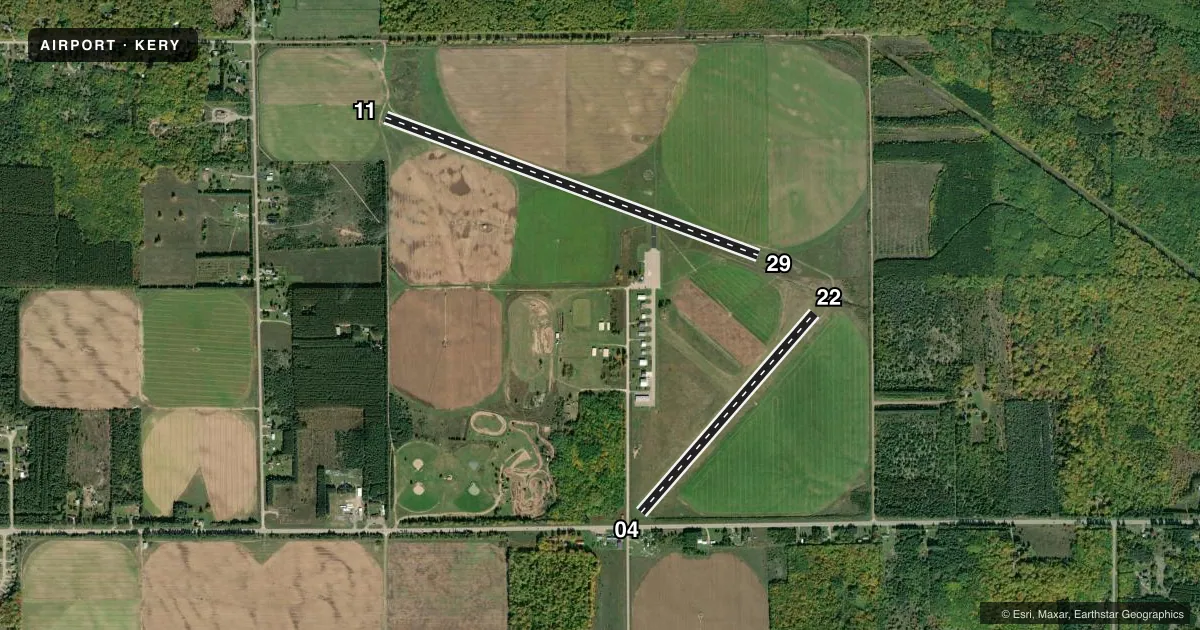
Runways & pattern
Full pagePattern entry · RWY 22
LEFT TRAFFIC| Runway | Heading (°M) | Length | Surface | Traffic |
|---|---|---|---|---|
| 11/29 | 104° / 284° | 4,304 ft | ASPH | Standard L |
| 04/22Favored | 35° / 215° | 2,856 ft | TURF | Standard L |
Runway end performance
| End | TORA | TODA | ASDA | LDA | VGSI | Approach lights | Obstruction |
|---|---|---|---|---|---|---|---|
| 11 | — | — | — | — | PAPI 4-box left(3.2°) | — | — |
| 29 | — | — | — | — | PAPI 4-box left(3.2°) | — | — |
| 04 | — | — | — | — | — | — | 10', fence, 0' from thr, 125' R of cntrln, slope 0 |
| 22 | — | — | — | — | — | — | 24', trees, 261' from thr, 116' R of cntrln, slope 10 |
Declared distances in feet. TORA = takeoff run available, TODA = takeoff distance, ASDA = accelerate-stop, LDA = landing distance.
Airport sketch
Runways drawn to scale from FAA survey coordinates, rendered over satellite imagery. Not for navigation.
Approaches & charts
Services on the field
Fuel grades, oxygen, maintenance, ramp storage and lighting — as declared to the FAA by the airport operator.
Fuel & services
- Fuel
- 100LLA+
- Oxygen (bottled)
- Not available
- Oxygen (bulk)
- Not available
- Airframe repair
- Not available
- Power plant repair
- Not available
Ramp & ground
- Transient storage
- Tie-down
- Hangar
- Landing fee
- No fee published
- Customs
- Not available
- Lighting schedule
- SEE RMK
- Beacon schedule
- SS-SR
- Beacon
- White / Green (civil land)(WG)
- Wind indicator
- Lighted
- Segmented circle
- Yes
Fuel & FBOs
Cheapest 100LL and Jet A on the field and nearby. Always confirm with the FBO before taxi.
Airport notes
Surface conditions, obstructions, local procedures, lighting outages and other notes published with each FAA cycle.
General notes
- DEER, BIRDS, & WILDLIFE ON & INVOF ARPT.
- FOR CD IF UNA TO CTC ON FSS FREQ, CTC MINNEAPOLIS ARTCC AT 651-463-5588.
Lighting notes
- ACTVT WIND CONE; REIL RWY 11 & 29; PAPI RWY 11 & 29; MIRL RWY 11/29 - CTAF.
Runway surface & condition
- 04/22CLSD WHEN SNOW COVD EXC FOR SKI EQUIPPED ACFT.
Approach & departure obstructions
- 04APCH RATIO 19:1 TO DTHR OVR +82 FT TREES, 1600 FT DIST, 120L.
- 043 FT YELLOW CONES.
- 223 FT YELLOW CONES.
- 04CTLNG OBSTN EXCEEDS A 45 DEG SLP.
- 04ALSO +16 FT ROAD, 0 FT DIST, 125 FT R, APCH RATIO 0:1.
Other notes
- 3WKENDS O/R.
- MANAGERCELL.
VFR map & nearby airports
VFR sectional. Tap any ICAO chip to open that airport.
Key facts · KERY
Answer card- ICAO
- KERY
- Name
- LUCE COUNTY
- Location
- NEWBERRY, MICHIGAN
- Elevation
- 869.2 ft MSL
- Traffic pattern altitude
- 1,869.2 ft MSL (1,000 AGL)
- Control tower
- Non-towered (use CTAF)
- Total runways
- 2
- Longest runway
- 11/29 · 4,304 ft
- Published ILS approaches
- 0
- Published frequencies
- 2
- Magnetic variation
- 6°
- Current flight rules
- VFR
- Current wind
- 250° at 5 kt
- Favored runway now
- RWY 22
Luce County Airport sits in Newberry, Michigan. Field elevation is 869.2 ft MSL. The airport has two runways. The longest is 11/29 at 4,304 ft on asphalt. Runway 04/22 is 2,856 ft of turf. There is no control tower. CTAF and UNICOM are both 122.8.
No ILS approaches are published here. Pattern altitude is not published in the facts, so use the standard 1,000 ft AGL for light piston operations unless the current FAA Chart Supplement says otherwise. The on-field FBO is Luce County Airport. It carries 100LL and Jet A. Call (906) 293-2926 for current service details before you go.
The remarks matter here. Runway 04/22 is closed when snow covered except for ski-equipped aircraft. Runway 11/29 has runway end identifier lights, PAPI and medium intensity runway lighting on CTAF. Wildlife is also a factor. Deer, birds and other animals are reported on and near the field. There are also published obstructions near runway 04, so plan your approach carefully. If you need clearance delivery and cannot raise Flight Service, Minneapolis ARTCC is listed in the remarks. This is a good airport to brief with the current FAA Chart Supplement before departure, especially if you are planning a winter arrival or a night operation.