METAR & TAF KANJ
Current METAR
Observed 18:08Z
KANJ 271808Z AUTO VRB04KT 10SM SCT013 26/21 A2966 RMK AO2 T02560206
- Wind
- VAR @ 4 kt
- Visibility
- 10 SM
- Temp / Dew
- 26°C / 21°C
- Altimeter
- 29.66 inHg
- Clouds
- SCT
- Density alt
- 2,531 ft
- Ceiling
- Unlimited
- Rules
- VFR
Airport info & contacts
Manager on record, flight service, ARTCC, attendance schedule and pattern altitude — published by the FAA and refreshed every 28 days.
Location
- From city
- 1 NM SW
- VFR sectional
- LAKE HURON
- ARTCC
- ZYZ · TORONTO
- NOTAM facility
- ANJ (NOTAM-D)
Airport manager
- Name
- TOM BROWN
- Phone
- 906-635-0252
- Address
- 2144 MERIDIAN ST, SAULT SAINTE MARIE MI 49783-2608
Flight service · Hours
- FSS GRB
- GREEN BAY1-800-WX-BRIEF
- Attendance
- 0800-1700
Frequencies
Tap any row to copy the frequency to your clipboard.
Runways & pattern
Full pagePattern entry · RWY 32
RIGHT TRAFFICRunway end performance
| End | TORA | TODA | ASDA | LDA | VGSI | Approach lights | Obstruction |
|---|---|---|---|---|---|---|---|
| 14 | — | — | — | — | PAPI 2-box left(3°) | — | — |
| 32 | — | — | — | — | PAPI 2-box left(3°) | — | 10', road, 200' from thr, 200' R of cntrln, slope 1 |
Declared distances in feet. TORA = takeoff run available, TODA = takeoff distance, ASDA = accelerate-stop, LDA = landing distance.
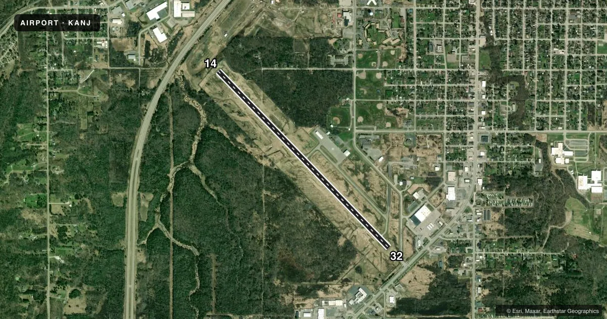
Airport sketch
Runways drawn to scale from FAA survey coordinates, rendered over satellite imagery. Not for navigation.
Approaches & charts
Services on the field
Fuel grades, oxygen, maintenance, ramp storage and lighting — as declared to the FAA by the airport operator.
Fuel & services
- Fuel
- 100LLA+
- Airframe repair
- Major
- Power plant repair
- Major
- Other services
- INSTR
Ramp & ground
- Transient storage
- Tie-down
- Hangar
- Landing fee
- No fee published
- Customs
- Available
- Lighting schedule
- SEE RMK
- Wind indicator
- Yes
- Segmented circle
- Yes
Fuel & FBOs
Cheapest 100LL and Jet A on the field and nearby. Always confirm with the FBO before taxi.
Airport notes
Surface conditions, obstructions, local procedures, lighting outages and other notes published with each FAA cycle.
General notes
- US CUSTOMS AVBL ON REQ CALL 906-632-2631 1 HR PRIOR TO ARR.
- DEER, BIRDS, & WILDLIFE ON & INVOF ARPT.
- PILOTS OPRG IN CANADIAN/US CLASS D ASP ARE RQRD TO ESTAB & MNTN TWO-WAY COM & OBTAIN ATC CLNC FM SAULT STE MARIE ATCT (SOO TWR 118.8) PRIOR TO OPRG IN THE CLASS D ASP. TFC ADZY SER (118.8) IS AVBL IN THE US CLASS E SFC EXTN 0630-2230.
- 50 FT DROP OFF, N END, 200 FT FR RWY END.
- FOR CD CTC MINNEAPOLIS ARTCC AT 651-463-5588.
Lighting notes
- ACTVT REIL RWY 14 & 32; PAPI RWY 14 & 32; MIRL RWY 14/32 - CTAF.
Fuel notes
- 100LLFUEL AVBL H24 SELF SVC VIA CREDIT CARD.
Approach & departure obstructions
- 14+5 FT FENCE, 130 FT DIST, 250 FT L/R.
- 32+6 FT FENCE, 201 FT DIST, 126 FT R.
- 14APCH RATIO 50:1 TO DTHR.
- 32APCH RATIO 28:1 TO DTHR OVR +10 FT ROAD, 280 FT DIST, 292 FT R.
Other notes
- PRVDD OBSTNS WHICH PENETRATE 20:1 APCH SFC BE REMOVED/LWRD OR THR DSPLCD & MKD TO PRVD UNOBSTD 20:1 RWY APCH SFC; VFR USE ONLY; ALL OTHER RWY SFCS EXC RWY 14/32 BE CLEARLY MKD CLSD; AMGR ISSUES APROP NOTICES & INSURES ARPT.
- MANAGERCELL 906-748-1468.
VFR map & nearby airports
VFR sectional. Tap any ICAO chip to open that airport.
Key facts · KANJ
Answer card- ICAO
- KANJ
- Name
- SAULT STE MARIE MUNI/SANDERSON FLD
- Location
- SAULT STE MARIE, MICHIGAN
- Elevation
- 716.4 ft MSL
- Traffic pattern altitude
- 1,716.4 ft MSL (1,000 AGL)
- Control tower
- Non-towered (use CTAF)
- Total runways
- 1
- Longest runway
- 14/32 · 5,234 ft
- Published ILS approaches
- 0
- Published frequencies
- 2
- Magnetic variation
- 7°
- Current flight rules
- VFR
- Current wind
- 000° at 4 kt
- Favored runway now
- RWY 32
Sault Ste Marie Muni/Sanderson Fld is in Sault Ste Marie, Michigan. Field elevation is 716.4 ft MSL. The airport has one runway, 14/32, which is 5,234 ft long. There is no control tower. CTAF and UNICOM are both 122.7. No ILS approaches are published here.
Pattern altitude is not published. For light piston operations, use the standard 1,000 ft AGL unless the current Chart Supplement or local procedures say otherwise. The field is VFR use only per the published remarks. Runway 14 and 32 have runway end identifier lights. They also have PAPI and medium intensity runway lights. 100LL is available 24 hours a day through self-serve credit card. Sanderson Field is on the field. It carries AVGAS 100LL and Jet A. Call the FBO directly at (906) 635-0252 for current service details.
First-time pilots should pay close attention to the published obstacles and displaced threshold notes. There is a fence near runway 32. There are fence and terrain notes near runway 14. There is also a 50-foot drop off at the north end, 200 feet from the runway end. Deer, birds and wildlife are reported on and near the airport. U.S. Customs is available on request with one hour notice by phone. The airport sits near the Canadian border. Check the current Chart Supplement for any airspace or operating notes before you go.