METAR & TAF KDRM
Current METAR
Observed 20:15Z
KDRM 272015Z AUTO 25004KT 5SM BR OVC003 22/20 A2969 RMK AO2 T02170204
- Wind
- 250° @ 4 kt
- Visibility
- 5 SM
- Temp / Dew
- 22°C / 20°C
- Altimeter
- 29.69 inHg
- Clouds
- OVC
- Density alt
- 1,954 ft
- Ceiling
- 300 ft AGL
- Rules
- LIFR
Airport info & contacts
Manager on record, flight service, ARTCC, attendance schedule and pattern altitude — published by the FAA and refreshed every 28 days.
Location
- From city
- 1 NM SW
- VFR sectional
- LAKE HURON
- ARTCC
- ZYZ · TORONTO
- NOTAM facility
- DRM (NOTAM-D)
Airport manager
- Name
- JAMES BAILEY II
- Phone
- 906-493-5411
- Address
- 34264 S TOWNLINE RD, DRUMMOND ISLAND MI 49726-9636
Flight service · Hours
- FSS GRB
- GREEN BAY1-800-WX-BRIEF
- Attendance
- MON-SAT · 0800-1700
Frequencies
Tap any row to copy the frequency to your clipboard.
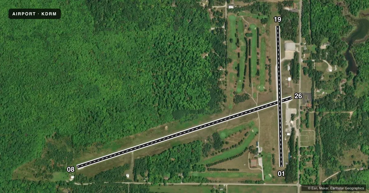
Runways & pattern
Full pagePattern entry · RWY 26
LEFT TRAFFIC| Runway | Heading (°M) | Length | Surface | Traffic |
|---|---|---|---|---|
| 08/26Favored | 65° / 245° | 4,000 ft | ASPH | Standard L |
| 01/19 | 351° / 171° | 2,500 ft | ASPH-TURF | Standard L |
Runway end performance
| End | TORA | TODA | ASDA | LDA | VGSI | Approach lights | Obstruction |
|---|---|---|---|---|---|---|---|
| 08 | — | — | — | — | PAPI 2-box left(3°) | — | 42', trees, 200' from thr, 181' R of cntrln, slope 0 |
| 26 | — | — | — | — | PAPI 2-box left(3°) | — | 15', road, 200' from thr, 125' R of cntrln, slope 1 |
| 01 | — | — | — | — | — | — | 48', trees, 0' from thr, 125' R of cntrln, slope 0 |
| 19 | — | — | — | — | — | — | 73', trees, 0' from thr, 125' R of cntrln, slope 0 |
Declared distances in feet. TORA = takeoff run available, TODA = takeoff distance, ASDA = accelerate-stop, LDA = landing distance.
Airport sketch
Runways drawn to scale from FAA survey coordinates, rendered over satellite imagery. Not for navigation.
Approaches & charts
Services on the field
Fuel grades, oxygen, maintenance, ramp storage and lighting — as declared to the FAA by the airport operator.
Fuel & services
- Fuel
- 100LLMOGAS
- Other services
- SALES
Ramp & ground
- Transient storage
- Tie-down
- Landing fee
- No fee published
- Customs
- Not available
- Lighting schedule
- SEE RMK
- Beacon schedule
- SS-SR
- Beacon
- White / Green (civil land)(WG)
- Wind indicator
- Lighted
- Segmented circle
- Yes
Fuel & FBOs
Cheapest 100LL and Jet A on the field and nearby. Always confirm with the FBO before taxi.
Airport notes
Surface conditions, obstructions, local procedures, lighting outages and other notes published with each FAA cycle.
General notes
- GOLF CARTS & PEDESTRIANS XNG RWY 08/26 DUE TO GOLF CRS ON BOTH SIDES.
- DEER, BIRDS, & WILDLIFE ON & INVOF ARPT.
- D22 SPB LCTD 1.5 NM NORTH.
- FOR CD CTC MINNEAPOLIS ARTCC AT 651-463-5588.
Lighting notes
- ACTVT PAPI RWY 08 & 26; MIRL RWY 08/26 - CTAF.
Approach & departure obstructions
- 08+4 FT FENCE, 20 FT DIST; +10 FT HILL, 10 FT DIST, 50 FT L; +18 FT BLDG, 97 FT DIST, 50 FT R; +50 FT TREES, 20 FT DIST, 90 FT L/R.
- 26+6 FT FENCE, 54 FT DIST; +15 FT ROAD, 112 FT DIST; +20 FT BLDG, 0 FT DIST, 200 FT R.
- 013 FT YELLOW CONES.
- 193 FT YELLOW CONES.
- 19CTLG OBSTN EXCEEDS A 45 DEG SLP.
- 26APCH RATIO 4:1 TO DTHR OVR 75 FT TREE, 321 FT DIST, 247 FT L.
- 08CTLG OBSTN EXCEEDS A 45 DEG SLP.
- 01CTLG OBSTN EXCEEDS A 45 DEG SLP.
Other notes
- THIS AIRPORT HAS BEEN SURVEYED BY THE NATIONAL GEODETIC SURVEY.
- 01/19CNTR 20 FT OF RWY FM INT RWY 08/26 NORTH TO THE HNGR LINE IS ASPH, RMNDR OF RWY TURF.
VFR map & nearby airports
VFR sectional. Tap any ICAO chip to open that airport.
Key facts · KDRM
Answer card- ICAO
- KDRM
- Name
- DRUMMOND ISLAND
- Location
- DRUMMOND ISLAND, MICHIGAN
- Elevation
- 668.4 ft MSL
- Traffic pattern altitude
- 1,668.4 ft MSL (1,000 AGL)
- Control tower
- Non-towered (use CTAF)
- Total runways
- 2
- Longest runway
- 08/26 · 4,000 ft
- Published ILS approaches
- 0
- Published frequencies
- 2
- Magnetic variation
- 7°
- Current flight rules
- LIFR
- Current wind
- 250° at 4 kt
- Favored runway now
- RWY 26
Drummond Island Airport sits on Drummond Island in Michigan. Field elevation is 668.4 ft MSL. The airport has two runways. The longest is runway 08/26 at 4,000 ft. There is no control tower. CTAF and UNICOM are both 122.8. No ILS approaches are published here.
Pattern altitude is not published. Use the standard 1,000 ft AGL pattern for light piston traffic unless the current Chart Supplement or local traffic calls for something different. Bailey Services is on the field. It carries 100LL and MOGAS. Call (906) 493-5411 for current service details.
Runway 08/26 has medium intensity lighting that is controlled on CTAF. The PAPI for runways 08 and 26 is activated from the radio. Runway 01/19 is a turf runway with an asphalt center section near the intersection with 08/26. Watch the published obstructions. There are close-in obstacles near runway 08. The 01 and 19 ends also have cataloged obstructions. Golf carts and pedestrians cross runway 08/26 because of the golf course on both sides. That makes local traffic awareness important. Clearance delivery is handled through Minneapolis ARTCC at 651-463-5588.