METAR & TAF MI4
MI4 does not publish a METAR.
Showing the nearest reporting station: KDRM (DRUMMOND ISLAND) · 2.9 NM away. Conditions at MI4 may differ.
METAR · KDRM
Observed 18:55Z
KDRM 271855Z AUTO 19005KT 10SM OVC011 25/21 A2968 RMK AO2 T02450206
- Wind
- 190° @ 5 kt
- Visibility
- 10 SM
- Temp / Dew
- 25°C / 21°C
- Altimeter
- 29.68 inHg
- Clouds
- OVC
- Density alt
- 2,217 ft
- Ceiling
- 1,100 ft AGL
- Rules
- MVFR
Airport info & contacts
Manager on record, flight service, ARTCC, attendance schedule and pattern altitude — published by the FAA and refreshed every 28 days.
Location
- From city
- 2 NM NE
- VFR sectional
- LAKE HURON
- ARTCC
- ZMP · MINNEAPOLIS
- NOTAM facility
- GRB
Airport manager
- Name
- PAUL LAPOINT
- Phone
- 906-493-5445
- Address
- 32884 SOUTH MAXTON ROAD, DRUMMOND ISLAND MI 49726
Flight service · Hours
- FSS GRB
- GREEN BAY1-800-WX-BRIEF
Frequencies
Tap any row to copy the frequency to your clipboard.
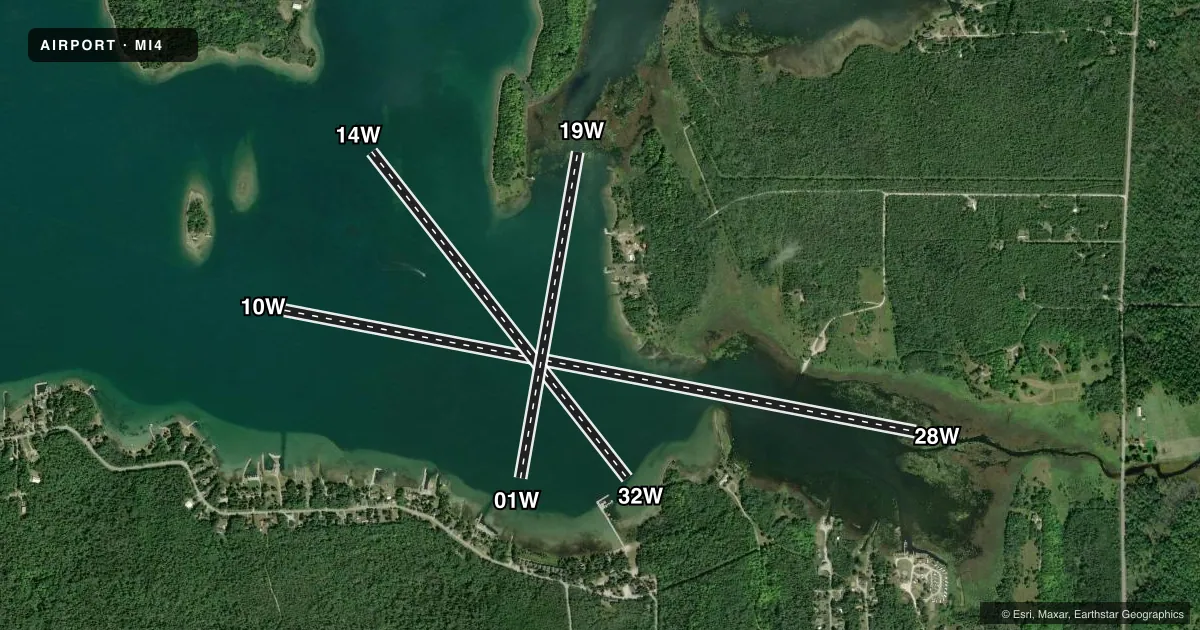
Runways & pattern
Full pagePattern entry · RWY 19W
LEFT TRAFFICAirport sketch
Runways drawn to scale from FAA survey coordinates, rendered over satellite imagery. Not for navigation.
Approaches & charts
Services on the field
Fuel grades, oxygen, maintenance, ramp storage and lighting — as declared to the FAA by the airport operator.
Fuel & services
- Fuel
- Not available
Ramp & ground
- Transient storage
- Not published
Fuel & FBOs
Cheapest 100LL and Jet A on the field and nearby. Always confirm with the FBO before taxi.
Airport notes
Surface conditions, obstructions, local procedures, lighting outages and other notes published with each FAA cycle.
Other notes
- MANAGERPAULLAPOINT@YAHOO.COM
VFR map & nearby airports
VFR sectional. Tap any ICAO chip to open that airport.
Key facts · MI4
Answer card- ICAO
- MI4
- Name
- LAPOINT
- Location
- DRUMMOND ISLAND, MICHIGAN
- Elevation
- 580 ft MSL
- Traffic pattern altitude
- 1,580 ft MSL (1,000 AGL)
- Control tower
- Non-towered (use CTAF)
- Total runways
- 3
- Longest runway
- 10W/28W · 7,000 ft
- Published ILS approaches
- 0
- Published frequencies
- 1
- Magnetic variation
- –
- Current flight rules
- MVFR
- Current wind
- 190° at 5 kt
- Favored runway now
- RWY 19W
LAPOINT sits on Drummond Island in Michigan. Field elevation is 580 ft MSL. This is a water airport with three published runways. The longest is 10W/28W at 7,000 ft. The other water runways are 01W/19W at 3,600 ft and 14W/32W at 4,500 ft. There is no control tower. CTAF is 122.9.
No ILS approaches are published here. Pattern altitude is not published in the facts. Verify the current Chart Supplement before you go. The airport is listed as Class C in the supplied facts. Confirm current airspace and any local procedures on the sectional or with the airport operator before arrival.
There are no on-field FBOs listed. Plan to contact the airport operator directly if you need current service details. The published remarks say the manager can be reached by email. That is useful if you need local coordination before a water arrival.
For a first-time pilot, the main thing is to treat this as a water landing environment with multiple runway alignments. Check the current Chart Supplement for any noise or local operating notes before flying in. Verify the surface conditions, traffic flow and any seasonal limitations with the airport operator before departure.